The Petersburg Project
  • Home
    • About Us
  • Blog and Updates
  • The Crater
  • Petersburg in Pencil and Ink
    • Alfred R. Waud, Special Artist at Petersburg >
      • In Front of Petersburg
      • Waud Drawing of 5th Corps Fortifications
      • Rives Salient ("Fort Mahone")
      • Soldiers' Wells
      • The Mine Explosion
    • William Waud, Special Artist
    • Charles H. Chapin, Special Artist
    • Edwin Forbes, Special Artist at Petersburg
    • Joseph Becker, Special Artist at Petersburg
    • Edward Mullen, Special Artist at Petersburg
    • Andrew W. Warren, Special Artist
    • Winslow Homer, Special Artist
    • Enlisted Artists >
      • Charles Wellington Reed
      • Andrew McCallum
      • Francis Knowles
      • James William Pattison
      • Herbert Valentine
  • Steeples of Petersburg
  • Petersburg Photographs --So Many!
    • Working with Photographs
    • Petersburg Panorama 1865
    • City Point
    • City Point Wharf Explosion, Aug. 9, 1864
    • Fort Rice?? We don't think so!
    • Federal Picket Line, Jerusalem Plank Road
    • Timothy O'Sullivan, Photographer at Petersburg >
      • O'Sullivan and Vest Man
      • Fort Morton and Baxter Road Group
      • Fort Haskell Panorama
      • Fort Stedman Group
      • Gracie's Salient Group
      • Bombproofs behind Fort Haskell
      • Camp of the 50th N. Y. Engineers
    • John Reekie, Photographer for the Quartermaster Corps
    • Thomas C. Roche, Photographer at Petersburg
    • David Knox, Photographer at Petersburg
    • Andrew J. Russell, Photographer at Petersburg >
      • "Fort Mahone" CS Batteries 25 & 27
  • U. S. Military Railroad
    • Terminus of Military R. R. at City Point
    • City Point to Clark's Station
    • Pitkin's Station to Shooting Hill
    • Hancock's Junction/Jerusalem Plank Road
    • Parke's Station
    • Warren's Station
    • Patrick's Station
  • Maps and Topogs
    • Grand Medicine Pow-wow
    • Michler's Reports from Topographical Department
    • John E. Weyss, Cartographer
    • William H. Paine, Cartographer
    • Gilbert Thompson
  • Confederate Maps
    • Confederate Defenses 1862
    • Gilmer-Campbell Maps, 1864
    • Stevens Map July 1864
    • Fields of Fire
    • Coit's map of the Crater Battlefield
  • Federal Maps
    • June 18, 1864-Federal Engineers Map
    • June 21, 1864, Federal Engineers Map
    • June 22, 1864. Second Corps at Jerusalem Plank Road
    • June 30, 1864 -- XVIII Corps Map
    • Undated Federal Engineers Map--June-July, 1864
    • July 1864 Map of XVIII Corps Lines
    • 18th Corps, June 18, 1864
    • Native American Perspective of the Crater
    • August 28, 1864, Michler Map
    • IX Corps, Peebles and Pegrams Farms Oct. 1864
    • Army of the Potomac, Nov. 2, 1864
    • 1864, Coast Survey Map of Petersburg
    • Army of the Potomac, Routes of the Corps to Petersburg
    • Manuscript Survey, 1865
    • Michler-Weyss, Siege of Petersburg
    • Michler Map Series 1865-1867
    • 1871, Map of Recapture of Ft. Stedman
    • 1881, Boydton Plank Road
  • Confederate Forts and Batteries
    • Dimmock Line >
      • Priest Cap
      • French Rifle Pits
    • Fort Clifton
    • Confederate Leadworks
  • Federal Forts and Batteries
    • Battery X
    • Fort Alexander Hayes
    • Fort Avery
    • Fort Conahey
    • Fort Davis & Battery XXII
    • Fort Fisher
    • Fort Meikel --Photographic Views
    • Fort Morton
    • Fort Patrick Kelly
    • Fort Sedgwick, better known as Fort Hell,
    • Fort Wadsworth -- the Evolution
    • Fort Willcox or Battery XVI
  • Battlefield Features
    • Aiken House
    • Avery House
    • Bailey/Johnston Farm
    • Blandford Church
    • Broadway Landing, Appomattox River
    • The Crater
    • Cummings House
    • Dams and Inundations
    • Dunn House
    • Friend House >
      • View from Friend House toward Gibben complex and Petersburg
    • Globe Tavern / Weldon Railroad
    • Gregory House
    • Griffith Farm
    • Gurley House
    • Hare House
    • Hare House Hill
    • The "Horseshoe"
    • Jones House
    • Jordan House
    • Pegram's Farm
    • Peebles Farm, Pegrams Farm, Poplar Springs Church
    • Shands House
    • Taylor Farm >
      • The Ice House
      • Surviving Taylor Barn
    • U. S. Engineers at the Williams House
    • Williams House
  • Signal Towers and Trees
    • Some Operations of the Signal Corps at Petersburg
  • Archeology
    • Geology of the Crater
    • Fieldwork -- Petersburg
    • Civil War Sinks
    • Deserted Confederate Camp
    • Gracie's Countermine
    • LIDAR Forts and Batteries
  • Articles, Papers, Presentations
    • Shiman: A Note on Maps
    • The Siege Landscape: Through Fire and Ice at Petersburg
    • "The Rebel in the Road"
    • "A Strange Sort of Warfare Underground"
    • Lost Trenches of Petersburg: June 17
    • Between the Lines
    • Combat Trenching: An Introduction
  • Encyclopedia
    • Glossary
    • The Battlefields
    • Siege Warfare
    • Union Lines
    • Confederate Lines
    • Combat >
      • X Corps, June 30, 1864, Attack
      • Combat Entrenching
      • Trench Warfare in Civil War History
      • Chamberlain at Petersburg, June 18, 1864
  • Kittens, Puppies & Ponies
  • Executions!
  • Civil War Combat Trenching
  • Pontoon Bridges
  • Depot Hospital at City Point
  • New: Shot tower

Federal Engineers Map dated June 21, 1864

This map shows the initial deployment of the Army of the Potomac with the XVIII Corps attached at the close of the opening battles (June16-18, 1864) and prior to the Jerusalem Plank Road offensive (June 21-23).Of particular interest on the sketched-in lines of Confederate earthworks--Dimmock Line and intermediary works--captured in previous fighting.Segmens of these works disappear from later Federal maps. From north to south, the corps were deployed--18th, 9th, 5th, 2nd, and 6th with the 6th Corps drawn into a defensive hook. As the crow flies, the Federals along the Jerusalem Plank Road were only about two and a half miles from the Weldon Railroad. The map shows, however, that most of the intervening ground was unknown and unexplored. This lack of full reconnaissance did not bode well for the coming offensive.
Picture
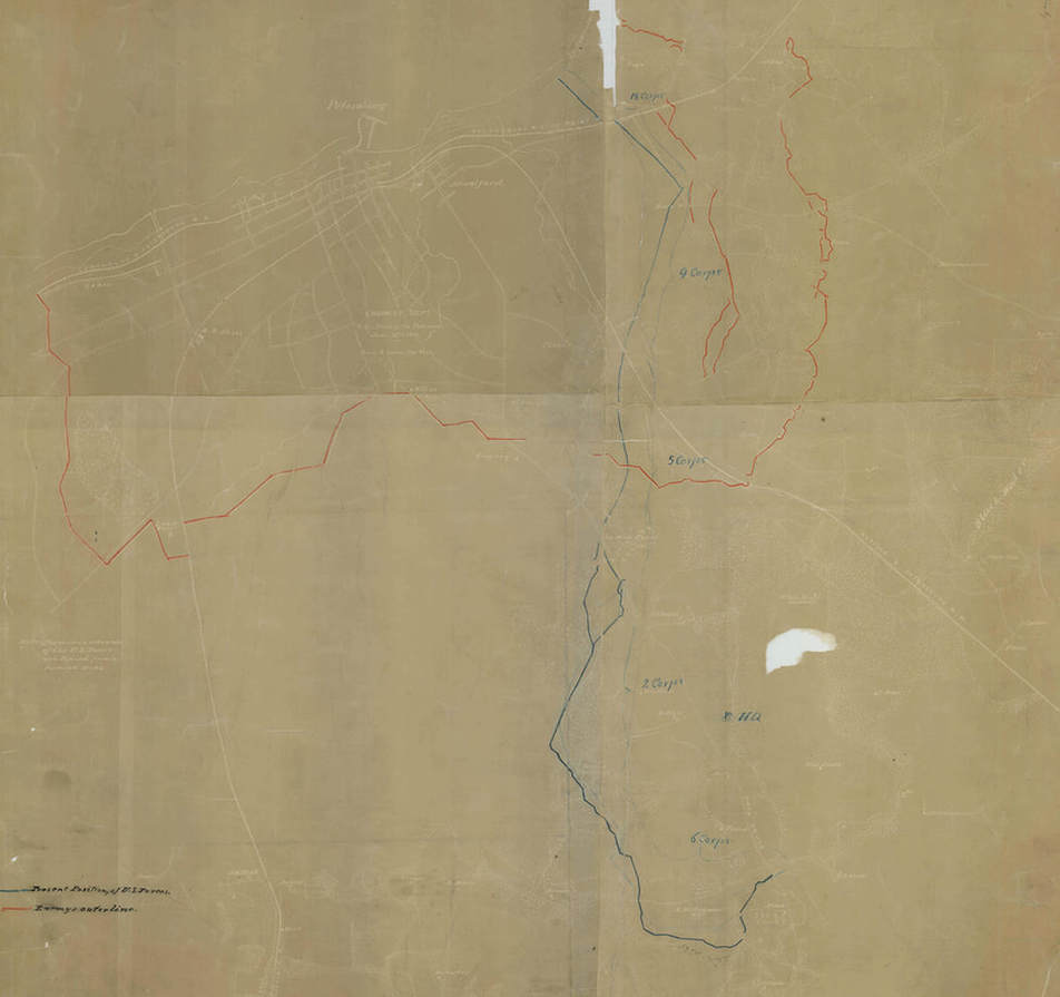
This early siege map shows relative positions of the Federal Army Corps on June 21, 1864, photoprocessed with annotations. Scale- 4 in. = 1 mile. Note the sketchy nature of the basemap, but there is already considerable improvement in filling in the blank spaces since the June 18th maps. NARA RG77 (see Stevenson, Guide to CW Maps in the National Archives, pg. 48).
Picture
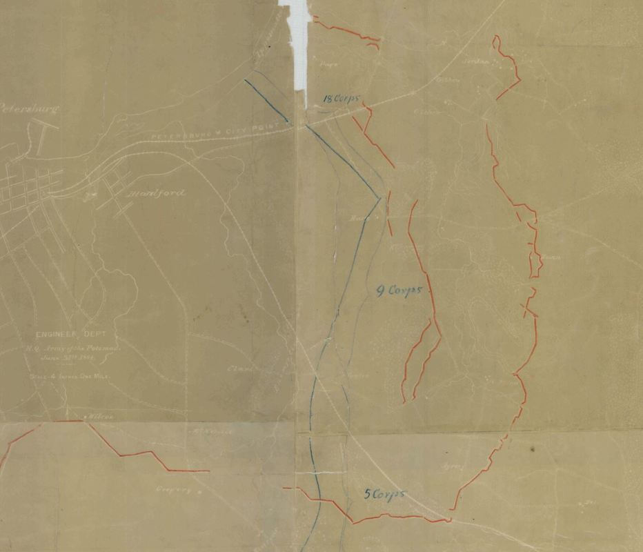
H.Q. Army of the Potomac. Detail showing lines opposite Petersburg, scale 4 inches = 1 mile. Confederate lines from June 15-17 are sketched in red.
Picture
Proudly powered by Weebly
Picture