The Petersburg Project
  • Home
    • About Us
  • Blog and Updates
  • Postwar Visit to the Battlefields 1866
  • Civil War Combat Trenching
  • Views of the City of Petersburg
    • Petersburg Panorama 1865
    • Steeples of Petersburg
    • Petersburg Mill Photographs
  • The Mine Explosion and its Crater
  • Petersburg in Pencil and Ink
    • Alfred R. Waud, Special Artist at Petersburg >
      • Waud Drawing of 5th Corps Fortifications
    • William Waud, Special Artist
    • Charles H. Chapin, Special Artist
    • Joseph Becker, Special Artist at Petersburg
    • Edwin Forbes, Special Artist at Petersburg
    • Winslow Homer, Special Artist
    • Edward Mullen, Special Artist at Petersburg
    • Andrew W. Warren, Special Artist
    • Enlisted Artists >
      • Charles Wellington Reed
      • Andrew McCallum
      • Francis Knowles
      • James William Pattison
      • Herbert Valentine
      • Howard A. Camp
  • Petersburg Photographs --So Many!
    • Dimmock Battery 5 Photographs >
      • Working with Photographs
    • City Point
    • City Point Wharf Explosion, Aug. 9, 1864
    • Fort Rice?? We don't think so!
    • Federal Picket Line, Jerusalem Plank Road
    • Egbert Guy Fowx, Photographer at Petersburg
    • Timothy O'Sullivan, Photographer at Petersburg >
      • Harrison's Creek USCT Camps
      • Fort Morton and Baxter Road Group
      • Fort Haskell Panorama and Bomb Proofs
      • Fort Stedman Group
      • Gracie's Salient Group
      • Camp of the 50th N. Y. Engineers
    • David Knox, Photographer at Petersburg
    • William Redish Pywell, Photographer at Petersburg
    • John Reekie, Photographer at Petersburg
    • Thomas C. Roche, Photographer at Petersburg
    • Andrew J. Russell, Photographer at Petersburg >
      • "Fort Mahone" CS Batteries 25 & 27
  • U. S. Military Railroad
    • Terminus of Military R. R. at City Point
    • City Point to Clark's Station
    • Pitkin's Station to Shooting Hill
    • Hancock's Junction/Jerusalem Plank Road
    • Parke's Station
    • Warren's Station
    • Patrick's Station
  • Topographical Engineers -- Our Heroes
    • Grand Medicine Pow-wow
    • Michler's Reports from Topographical Department
    • John E. Weyss, Cartographer
    • William H. Paine, Cartographer
    • Gilbert Thompson
    • Albert Hanry Campbell, C.S.A. Cartographer
  • Confederate Maps
    • Confederate Defenses 1862
    • Gilmer-Campbell Maps, 1864
    • Stevens Map July 1864
    • Fields of Fire
    • Campbell Dinwiddie County 1864
    • Coit's map of the Crater Battlefield
  • Federal Maps
    • Army of the Potomac, Routes of the Corps to Petersburg
    • June 9 1864, Kautz Attack
    • June 18, 1864-Federal Engineers Maps
    • June 18, 1864, 18th Corps
    • June 19, 1864, Engineers Map
    • June 21, 1864, Federal Engineers Maps
    • June 22, 1864. Second Corps at Jerusalem Plank Road
    • June 29, 1864. Dept of VA and NC
    • June 30, 1864 -- XVIII Corps Map
    • June-July, Undated Federal Engineers Map-
    • July 29, 1864, Engineers Map, Annotated
    • July 1864 Map of XVIII Corps Lines
    • Crater, Native American Perspective of the Crater
    • August 1864, Michie Map - Bermuda 100
    • August 28, 1864, Michler Map
    • Aug.-Nov. 1864 Two Base Maps
    • September 13, 1864, Recon Map
    • Sept. 13-Oct.25 versions. Redoubts and Batteries
    • September 30, 1864, Warren Map
    • October 1864, Two IX Corps Maps
    • October 20, 1864. Benham's map of defenses of City Point
    • Nov. 2, 1864, Army of the Potomac
    • 1864, Coast Survey Map of Petersburg
    • Michler Map Series 1865-1867
    • 1864-1867, Michler-Weyss, Siege of Petersburg
    • 1865-1867, Manuscript Survey Maps
    • 1871, Map of Recapture of Ft. Stedman
    • 1881, Boydton Plank Road
  • Confederate Forts and Batteries
    • Dimmock Line >
      • Priest Cap
      • French Rifle Pits
    • Fort Clifton
    • "Fort Mahone" CS Batteries 25 & 27
    • Confederate 8-inch Columbiad
    • Leadworks
  • Federal Forts and Batteries
    • Union Battery Ten (X)
    • Fort Alexander Hayes
    • Fort Avery
    • Fort Conahey
    • Fort Davis & Battery XXII
    • Fort Fisher
    • Fort Meikel --Photographic Views
    • Fort Morton
    • Fort Patrick Kelly
    • Fort Sedgwick, better known as Fort Hell,
    • Fort Wadsworth -- the Evolution
    • Fort Willcox or Battery XVI
  • Battlefield Features
    • Aiken House
    • Armstrong's Mill
    • Avery House
    • Bailey/Johnston Farm
    • Blandford Church
    • Broadway Landing, Appomattox River
    • The Crater
    • Cummings House
    • Dams and Inundations
    • WW Davis Farm
    • Dunn House
    • Friend House >
      • View from Friend House toward Gibben complex and Petersburg
    • Gibbons Properties
    • Globe Tavern / Weldon Railroad
    • Gregory House
    • Griffith Farm
    • Gurley House
    • Hare House Hill
    • The "Horseshoe"
    • Jerusalem Plank Road
    • Jones House
    • Jordan House
    • Newmarket Racecourse
    • Pegram's Farm
    • Peebles Farm, Pegrams Farm, Poplar Springs Church
    • Shands House
    • Taylor Farm >
      • The Ice House
      • Surviving Taylor Barn
    • Williams House
  • Signal Towers and Trees
    • Some Operations of the Signal Corps at Petersburg
  • Archeology
    • Geology of the Crater
    • Fieldwork -- Petersburg
    • Civil War Sinks
    • Deserted Confederate Camp
    • Gracie's Countermine
    • LIDAR Forts and Batteries
  • Articles, Papers, Presentations
    • Shiman: A Note on Maps
    • The Siege Landscape: Through Fire and Ice at Petersburg
    • "The Rebel in the Road"
    • "A Strange Sort of Warfare Underground"
    • Lost Trenches of Petersburg: June 17
    • Between the Lines
    • Combat Trenching: An Introduction
    • Lowe -- Post-War Topographical Survey
    • Civil War Maps and Landscapes -- Observations
  • Kittens, Puppies & Ponies
  • Executions!
  • Notes on Leveled Earthworks
  • Depot Hospital at City Point
  • Pontoon Bridges
  • The Great Pontoon Bridge Across James River
  • Captain Robert Davis CSA

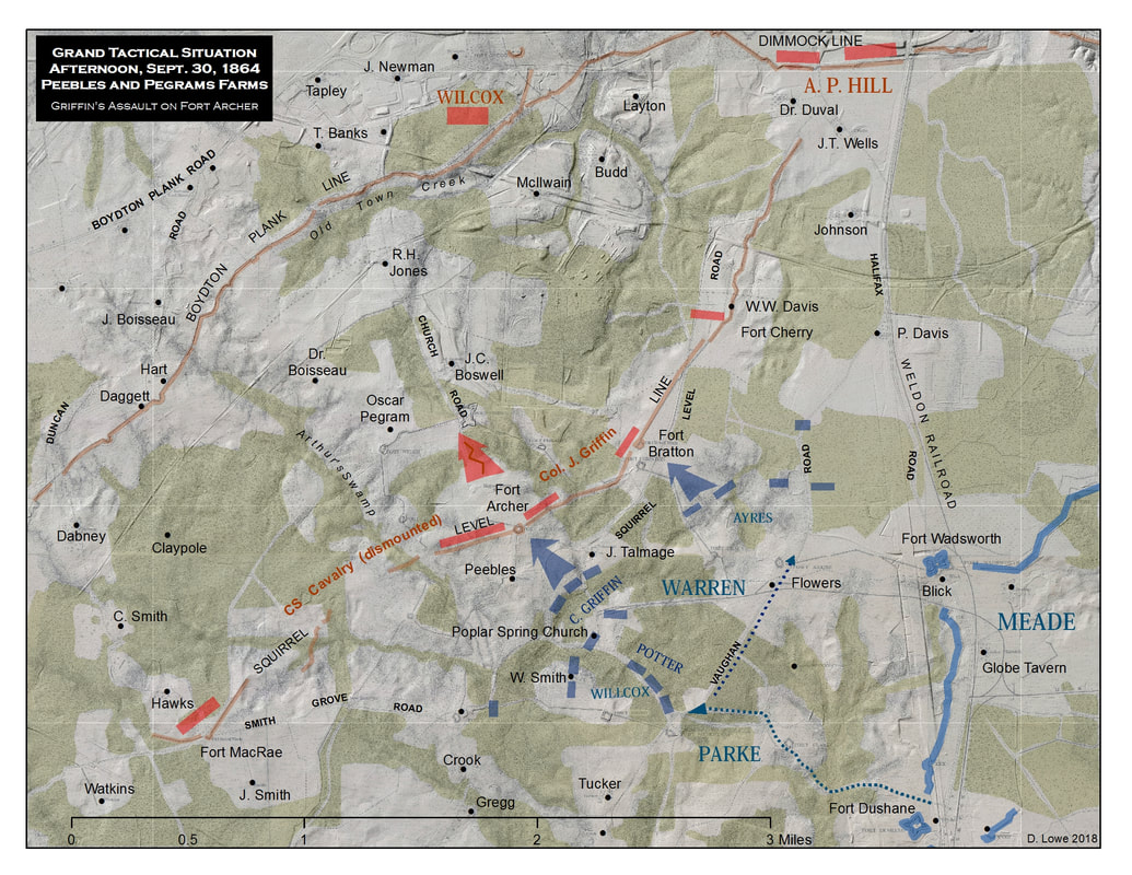
Poplar Springs Church, Peebles Farm, and Pegram's Farm

On September 30, 1864, about noon, two divisions of the V Army Corps under Maj. Gen. G. K. Warren, and two divisions of the IX Army Corps commanded by Maj. Gen. Parke, moved out of the defenses along the Weldon Railroad to test the strength of a newly built Confederate line that ran along the Squirrel Level Road. Thus began the Southside thrust of Grant's Fifth Offensive, intended, eventually, to cut the last supply lines into the city of Petersburg. A major objective was to cut the Boydton Plank Road. Deep ravines and heavily wooded terrain mostly funneled the advancing column along a single corridor -- the Poplar Spring Church Road. 
Picture
Poplar Spring Church was one of the first landmarks noted by Federal soldiers as they marched past the nondescript building. Special artist Joseph Becker accompanied the Ninth Corps as it passed through the woods around the church; his sketch--perhaps, the only depiction of the church--was afterwards turned into a woodcut for publication. Within a week, the church was described as "ruins" on a IX Corps map. No trace of the church remains today.
Picture
NAID:225809266. "Untitled map of Section of Country Southwest of Petersburg, Virginia, photo-reproduced for Engineer Department by L. E. Walker, U.S. Treasury Ext., Jan. 16, 1865. One of eleven copies of the area centered on the Poplar Grove Meeting House, showing locations of Peebles' and Pegram's farms. North is to the right of the page.
Picture
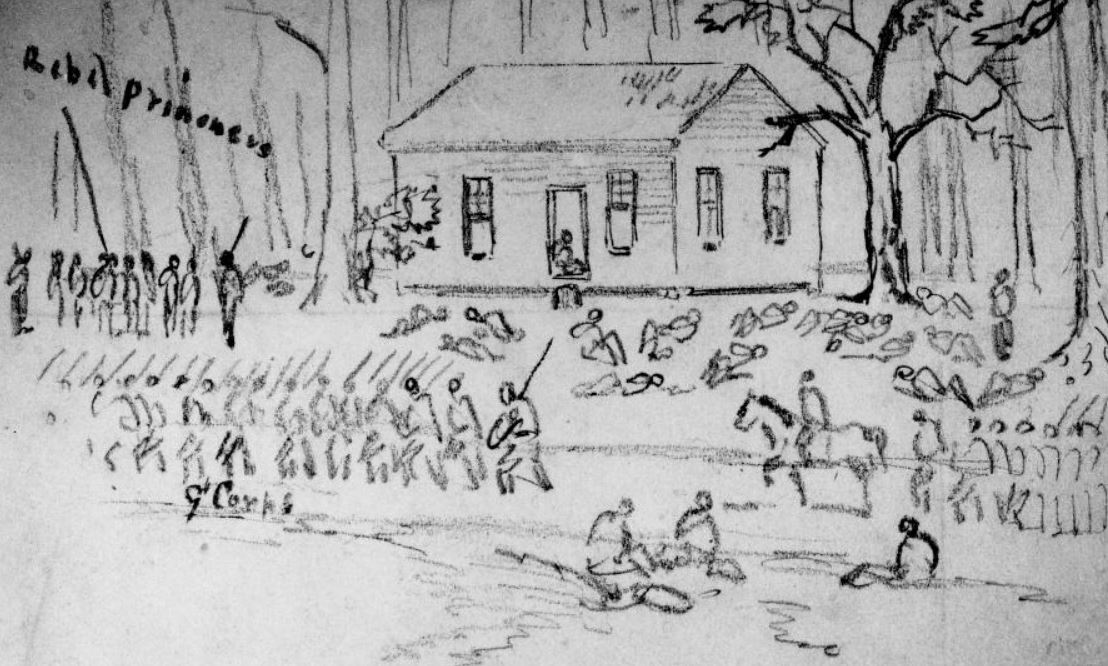
Original sketch of Poplar Spring Church by Joseph Becker, Becker Collection, Boston College. Cropped image reproduced here for comparison.
Picture
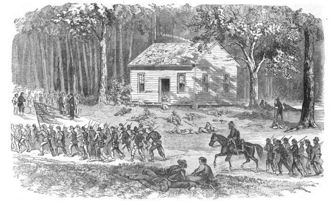
"Ninth Corps Passing Poplar Spring Church, September 30th, 1864 -- Confederate Prisoners Coming in Under Guard." Woodcut, Frank Leslie's Oct. 22, 1864.
The advancing Federals readily pushed aside Confederate skirmishers, and after emerging from the woods around the Poplar Grove Church, discovered the cleared area of the Peebles farm dominated by a Confederate redoubt, called Fort Archer. Maj. Gen. Charles Griffin brought up his Fifth Corps division and organized it for an assault on the earthwork. It was a formidable looking obstacle but only lightly manned by dismounted Confederate cavalrymen and four pieces of artillery.
Picture
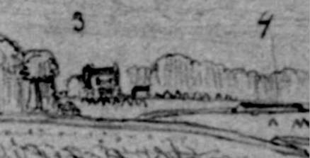
Peebles House (3) and Fort Archer (4) as depicted in a Joseph Becker sketch, dated October 11, 1864. Drawn from the vicinity of the Talmage house.
The attack on Fort Archer went forward as a swarm, as individual regiments of Gwyn's and Gregory's brigades followed their own instincts. Blue coats pressed over and through the incomplete abatis and converged on the redoubt, jumped into the ditch, and clambered up the parapet. Col. Norval Welch at the forefront of the 16th Michigan Infantry was shot in the head and thrown backward from the breastworks. Three of the Confederate guns and most of the defenders escaped through the sally port and were chased up Church Road. One three-inch rifle, taken from the Federals at Reams Station the previous month, again fell into Federal hands. The fort was afterwards reversed and named for Capt. J. H. Wheaton, 1st Michigan Infantry, who was killed in the fighting.
Picture
"Grant's Movement South of the James-Battle of Poplar Spring Church-Gallant Charge of a Part of the Fifth Corps on the Confederate Fort, September 30th, 1864". Woodcut from Frank Leslie's Scenes and Portraits of the Civil War (1894)
Picture
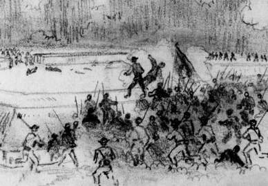
Fifth Corps troops overwhelming the Confederate defenders of Fort Archer. Sketch by Joseph Becker, Becker Collection, Boston College. Cropped image presented here for educational purposes.
In the meantime, Ayres Division, V Corps, pushed up the Squirrel Level Road, protecting the right flank of the corps, and reached out across a patch of open fields to capture lightly defended Fort Bratton. Some isolated regiments continued north along the now abandoned Confederate line until meeting stiffer resistance near Fort Cherry.
Picture
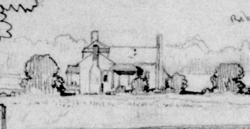
W. W. Davis house on Squirrel Level Road near "Fort Cherry" as depicted in a Joseph Becker sketch, dated Oct. 4, 1864. Becker described rebel sharpshooters firing from the small hole shown in the roof.
Picture
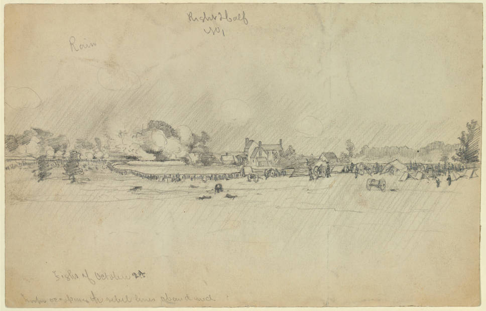
"Fight of Oct. 2d, 1864," artist unknown, in collection of art sent to Frank Leslie's Illustrated newspaper at the New York Historical Society. The sketch was not published. Inscribed at lower left: "Fight of October 2d./troops occupying the rebel lines about mid." That is likely the Pegram house in the mid-ground. The house and outbuildings were afterwards burnt to the ground.
Picture

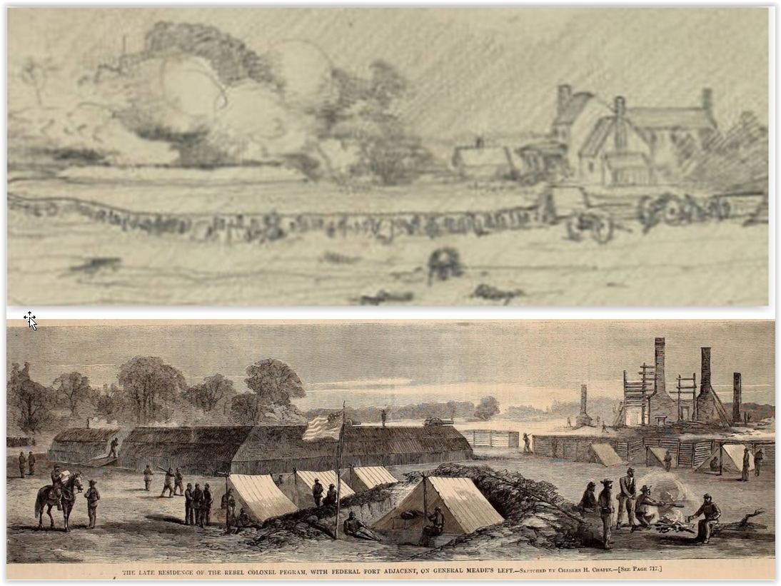
Pegram house ruins after the fire as sketched by C. H. Chapin and published as a woodcut. Fort Welch (left) was built on the site. Fort Welch survives in very good condition. Of the Pegram house, there is no trace but for the cemetery. It is a safe bet that the bricks were soon looted to provide chimneys and floors for the soldiers' winter quarters.

Fort Archer/Fort Wheaton is preserved within the battlefield park. Page updated 06/01/2024
Picture
Proudly powered by Weebly