The Petersburg Project
  • Home
    • About Us
  • Blog and Updates
  • Civil War Combat Trenching
  • Views of the City of Petersburg
    • Petersburg Panorama 1865
    • Steeples of Petersburg
    • Petersburg Mill Photographs
  • The Mine Explosion and its Crater
  • Petersburg in Pencil and Ink
    • Alfred R. Waud, Special Artist at Petersburg >
      • Waud Drawing of 5th Corps Fortifications
    • William Waud, Special Artist
    • Charles H. Chapin, Special Artist
    • Joseph Becker, Special Artist at Petersburg
    • Edwin Forbes, Special Artist at Petersburg
    • Winslow Homer, Special Artist
    • Edward Mullen, Special Artist at Petersburg
    • Andrew W. Warren, Special Artist
    • Enlisted Artists >
      • Charles Wellington Reed
      • Andrew McCallum
      • Francis Knowles
      • James William Pattison
      • Herbert Valentine
      • Howard A. Camp
  • Petersburg Photographs --So Many!
    • Dimmock Battery 5 Photographs >
      • Working with Photographs
    • City Point
    • City Point Wharf Explosion, Aug. 9, 1864
    • Fort Rice?? We don't think so!
    • Federal Picket Line, Jerusalem Plank Road
    • Egbert Guy Fowx, Photographer at Petersburg
    • Timothy O'Sullivan, Photographer at Petersburg >
      • Harrison's Creek USCT Camps
      • Fort Morton and Baxter Road Group
      • Fort Haskell Panorama and Bomb Proofs
      • Fort Stedman Group
      • Gracie's Salient Group
      • Camp of the 50th N. Y. Engineers
    • David Knox, Photographer at Petersburg
    • William Redish Pywell, Photographer at Petersburg
    • John Reekie, Photographer at Petersburg
    • Thomas C. Roche, Photographer at Petersburg
    • Andrew J. Russell, Photographer at Petersburg >
      • "Fort Mahone" CS Batteries 25 & 27
  • U. S. Military Railroad
    • Terminus of Military R. R. at City Point
    • City Point to Clark's Station
    • Pitkin's Station to Shooting Hill
    • Hancock's Junction/Jerusalem Plank Road
    • Parke's Station
    • Warren's Station
    • Patrick's Station
  • Topographical Engineers -- Our Heroes
    • Grand Medicine Pow-wow
    • Michler's Reports from Topographical Department
    • John E. Weyss, Cartographer
    • William H. Paine, Cartographer
    • Gilbert Thompson
    • Albert Hanry Campbell, C.S.A. Cartographer
  • Confederate Maps
    • Confederate Defenses 1862
    • Gilmer-Campbell Maps, 1864
    • Stevens Map July 1864
    • Fields of Fire
    • Campbell Dinwiddie County 1864
    • Coit's map of the Crater Battlefield
  • Federal Maps
    • Army of the Potomac, Routes of the Corps to Petersburg
    • June 9 1864, Kautz Attack
    • June 18, 1864-Federal Engineers Maps
    • June 18, 1864, 18th Corps
    • June 19, 1864, Engineers Map
    • June 21, 1864, Federal Engineers Maps
    • June 22, 1864. Second Corps at Jerusalem Plank Road
    • June 29, 1864. Dept of VA and NC
    • June 30, 1864 -- XVIII Corps Map
    • June-July, Undated Federal Engineers Map-
    • July 29, 1864, Engineers Map, Annotated
    • July 1864 Map of XVIII Corps Lines
    • Crater, Native American Perspective of the Crater
    • August 1864, Michie Map - Bermuda 100
    • August 28, 1864, Michler Map
    • Aug.-Nov. 1864 Two Base Maps
    • September 13, 1864, Recon Map
    • Sept. 13-Oct.25 versions. Redoubts and Batteries
    • September 30, 1864, Warren Map
    • October 1864, Two IX Corps Maps
    • October 20, 1864. Benham's map of defenses of City Point
    • Nov. 2, 1864, Army of the Potomac
    • 1864, Coast Survey Map of Petersburg
    • Michler Map Series 1865-1867
    • 1864-1867, Michler-Weyss, Siege of Petersburg
    • 1865-1867, Manuscript Survey Maps
    • 1871, Map of Recapture of Ft. Stedman
    • 1881, Boydton Plank Road
  • Confederate Forts and Batteries
    • Dimmock Line >
      • Priest Cap
      • French Rifle Pits
    • Fort Clifton
    • "Fort Mahone" CS Batteries 25 & 27
    • Confederate 8-inch Columbiad
    • Leadworks
  • Federal Forts and Batteries
    • Union Battery Ten (X)
    • Fort Alexander Hayes
    • Fort Avery
    • Fort Conahey
    • Fort Davis & Battery XXII
    • Fort Fisher
    • Fort Meikel --Photographic Views
    • Fort Morton
    • Fort Patrick Kelly
    • Fort Sedgwick, better known as Fort Hell,
    • Fort Wadsworth -- the Evolution
    • Fort Willcox or Battery XVI
  • Battlefield Features
    • Aiken House
    • Armstrong's Mill
    • Avery House
    • Bailey/Johnston Farm
    • Blandford Church
    • Broadway Landing, Appomattox River
    • The Crater
    • Cummings House
    • Dams and Inundations
    • WW Davis Farm
    • Dunn House
    • Friend House >
      • View from Friend House toward Gibben complex and Petersburg
    • Gibbons Properties
    • Globe Tavern / Weldon Railroad
    • Gregory House
    • Griffith Farm
    • Gurley House
    • Hare House Hill
    • The "Horseshoe"
    • Jerusalem Plank Road
    • Jones House
    • Jordan House
    • Newmarket Racecourse
    • Pegram's Farm
    • Peebles Farm, Pegrams Farm, Poplar Springs Church
    • Shands House
    • Taylor Farm >
      • The Ice House
      • Surviving Taylor Barn
    • Williams House
  • Signal Towers and Trees
    • Some Operations of the Signal Corps at Petersburg
  • Archeology
    • Geology of the Crater
    • Fieldwork -- Petersburg
    • Civil War Sinks
    • Deserted Confederate Camp
    • Gracie's Countermine
    • LIDAR Forts and Batteries
  • Articles, Papers, Presentations
    • Shiman: A Note on Maps
    • The Siege Landscape: Through Fire and Ice at Petersburg
    • "The Rebel in the Road"
    • "A Strange Sort of Warfare Underground"
    • Lost Trenches of Petersburg: June 17
    • Between the Lines
    • Combat Trenching: An Introduction
    • Lowe -- Post-War Topographical Survey
    • Civil War Maps and Landscapes -- Observations
  • Kittens, Puppies & Ponies
  • Executions!
  • Notes on Leveled Earthworks
  • Depot Hospital at City Point
  • Pontoon Bridges
  • The Great Pontoon Bridge Across James River
  • Captain Robert Davis CSA

​THE PETERSBURG PHOTOGRAPHS


Fort Stedman Group

Picture
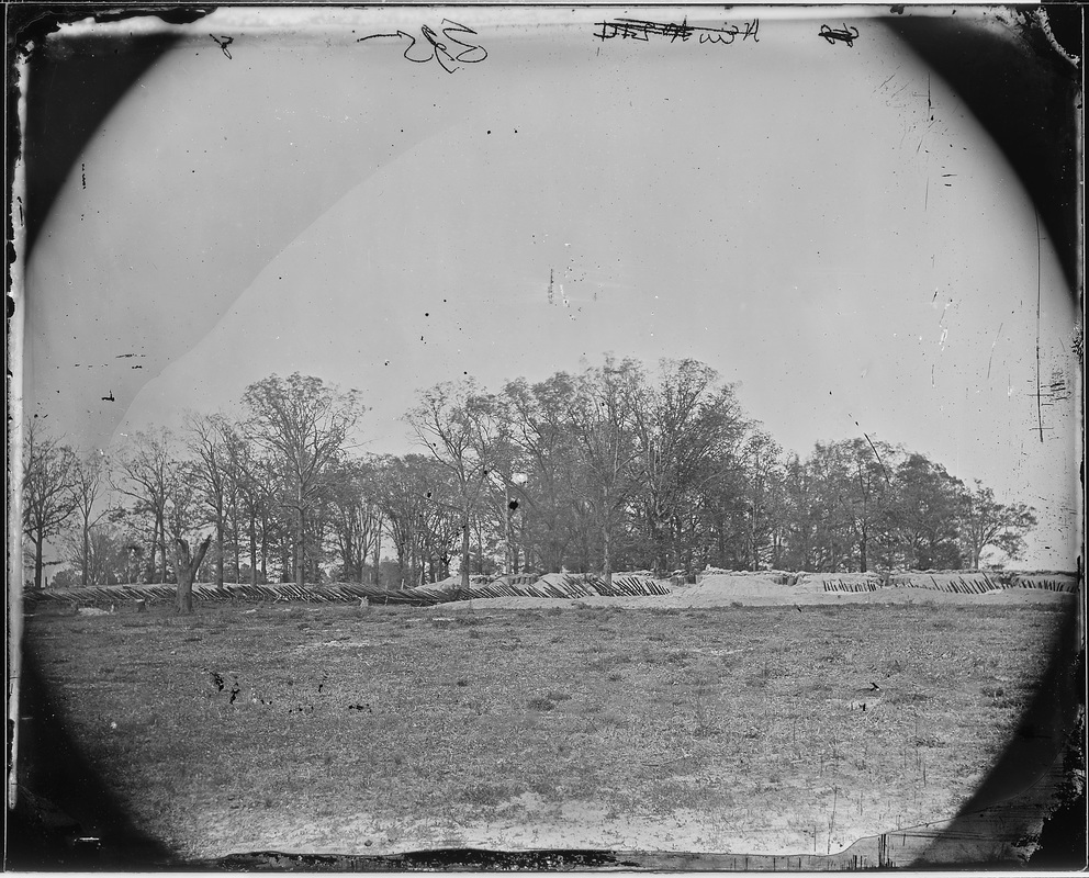
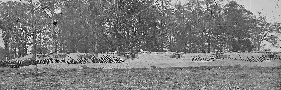
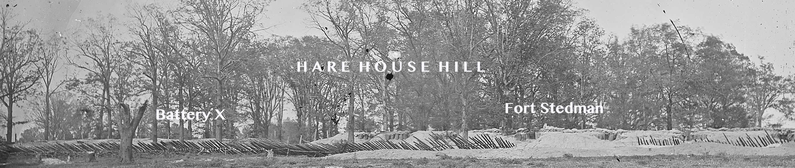
"Works in front of Petersburg, Va. Fort Stedman," National Archives (NWDNS-111-B-335). Battery 10 (on left), Fort Stedman (center-right) viewed from no-man's land. This grove of hardwoods on Hare House hill was an important landmark on the battlefield.
Picture
Residue of Battle. Detail of Fort Stedman from the above photograph, showing a gap cut in the fraise during the Confederate assault March 25, 1865. Attackers swarmed into the fort through these two embrasures at the southwestern angle.
Picture
NARA photograph, unattributed (likely O'Sullivan), 1865. Beneath the label "Fort Stedman," the fraise was cut away in the March 25th assault.
Picture
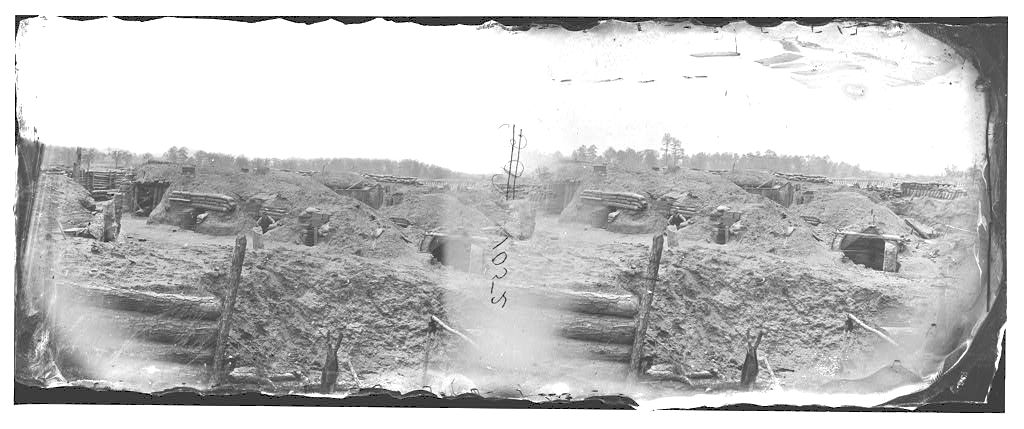
LC 00540. "Petersburg, Virginia. Fort Stedman in front of Petersburg," photograph by Timothy O'Sullivan. View looks south into Fort Haskell.
Picture
LC00540 Left half of stereo view. Fort Haskell in distance on left.
Picture
LC 00540 detail. View of Fort Haskell in the distance.
Picture
LC 32450. "Interior of Fort Steadman in front of Petersburg, Va." photograph by Timothy O'Sullivan.
Picture
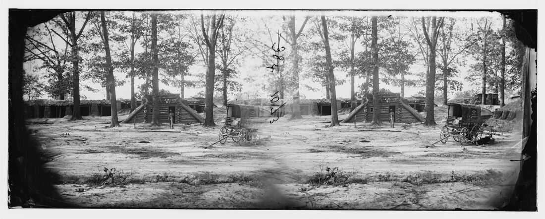
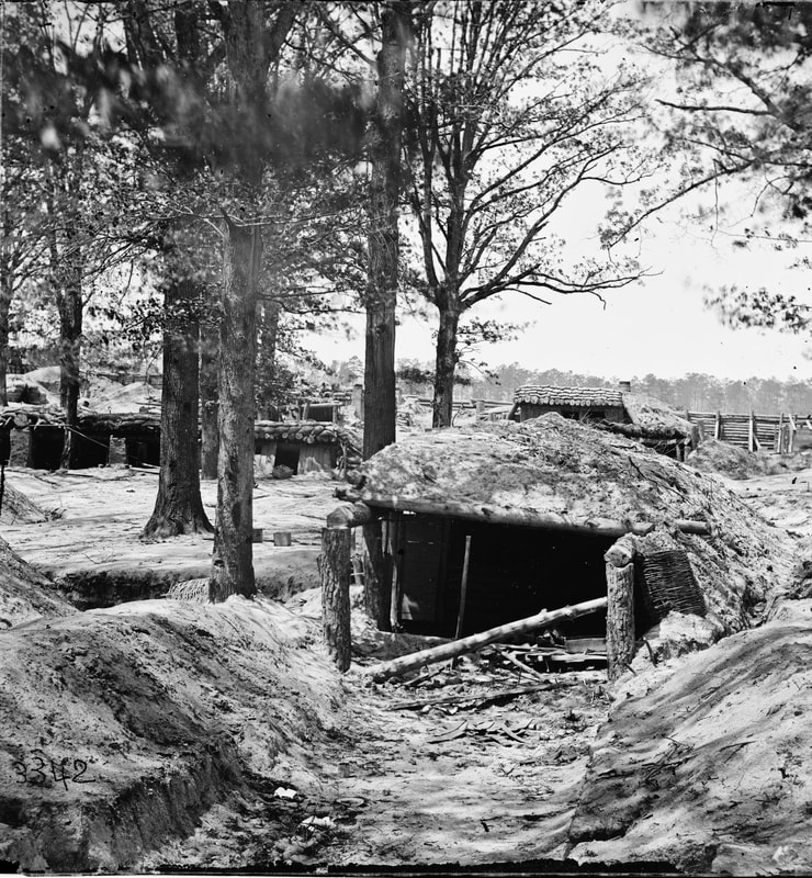
LC 00531 "Petersburg, Virginia. Bomb-proofs in front of Petersburg," stereo view by O'Sullivan of the rear of Fort Stedman, showing guardhouse. Engineer Department wagon with O'Sullivan or Pywell lounging in shadow. Black man, possibly a groom, posed by entrance.
Picture
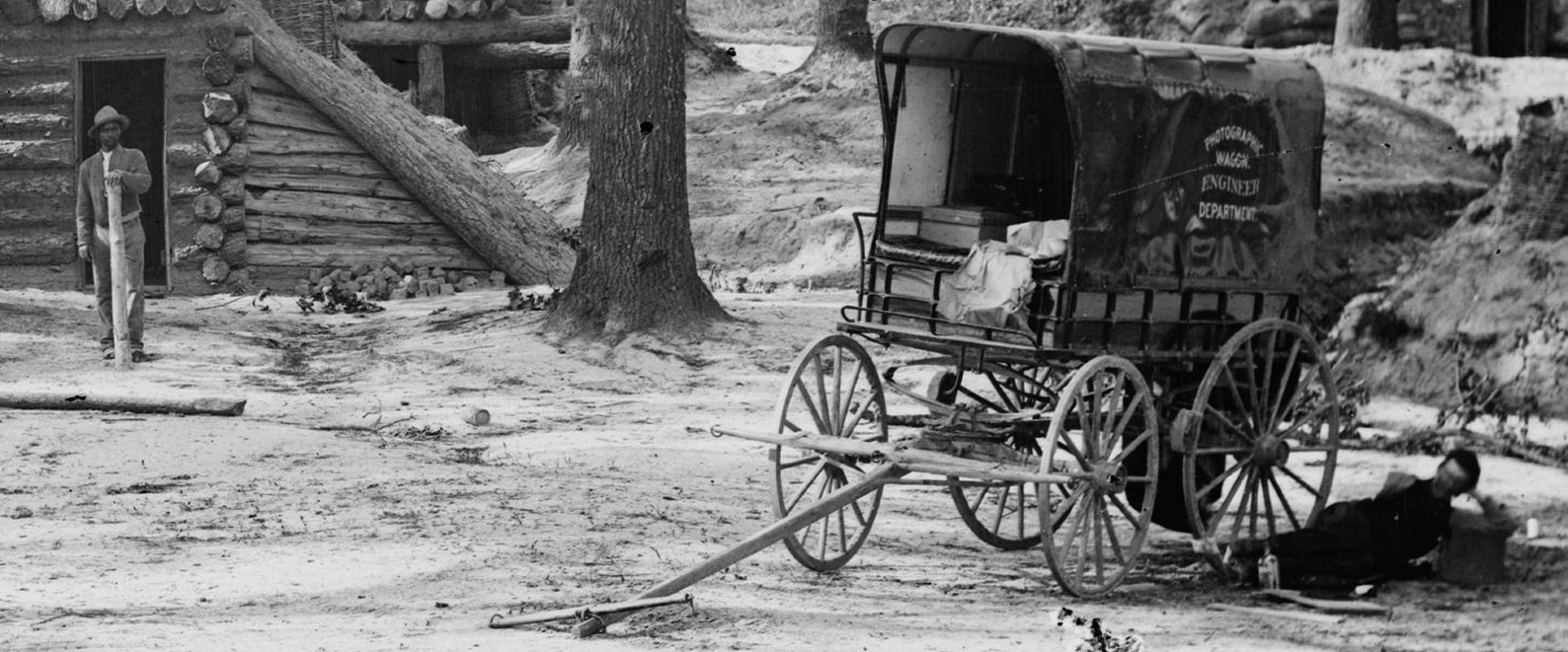
LC 00631 detail. Groom on left posed with sign post. Blurry photographer in shade of wagon on the right. Photographic supplies visible in wagon.
Picture
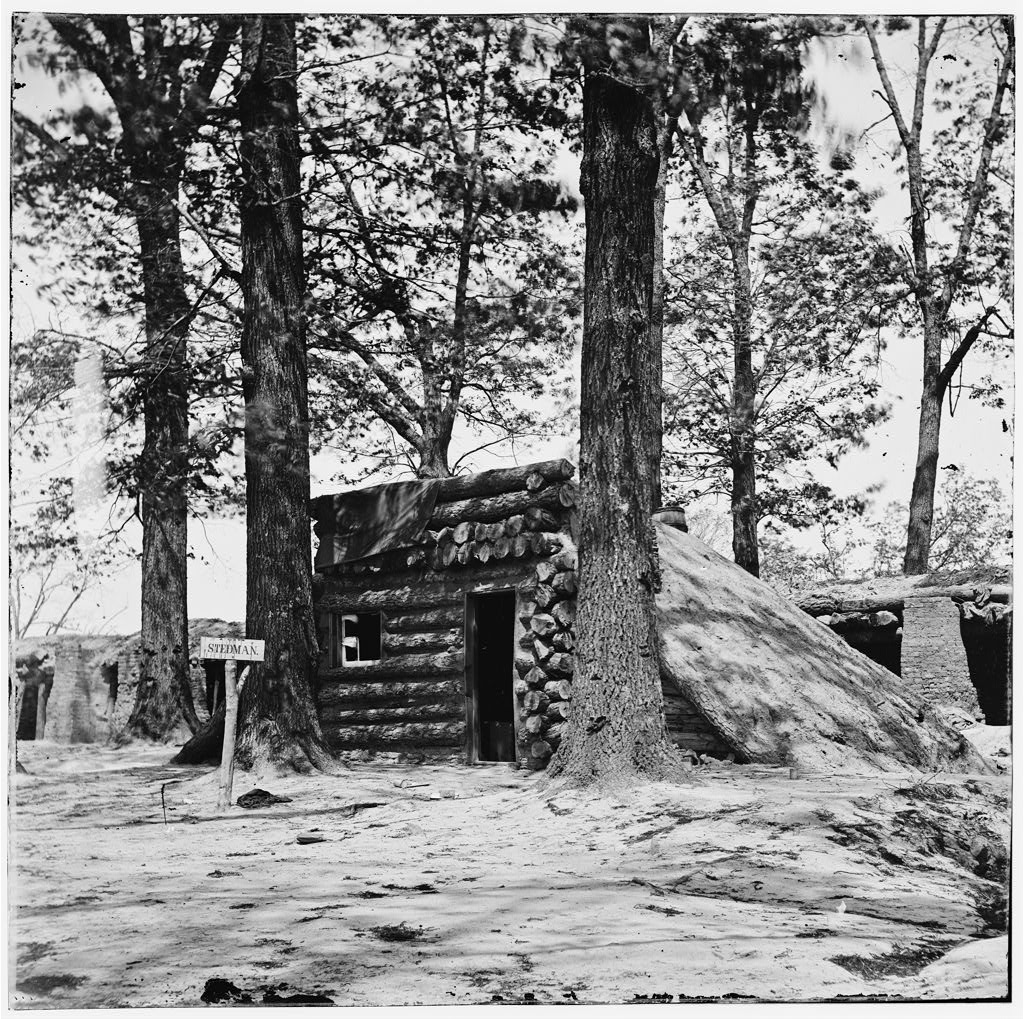
LC02853 "Petersburg, Virginia. Bomb-proof at Fort Stedman," image by O'Sullivan and Pywell, showing "Fort Stedman" sign in front of guard house. Trees heavily damaged, likely in fighting of March 25, 1865.
Picture
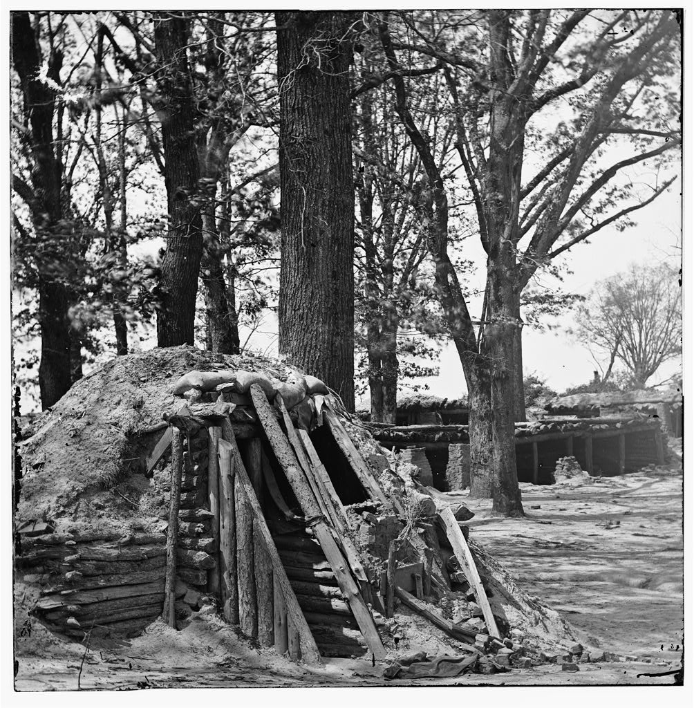
LC 02857 (LC-B811-3343B), "[Petersburg, Va. Interior of Fort Steadman; bomb-proof in foreground], lef't half of stereo view by Timothy O'Sullivan. Certainly in rear of Fort Stedman, not necessarily inside. Still puzzling out location of this one.
Picture
LCC 02855 "[Petersburg, Va. Interior of Fort Steadman]," right half of stereo view by O'Sullivan and Pywell. Exact location uncertain.
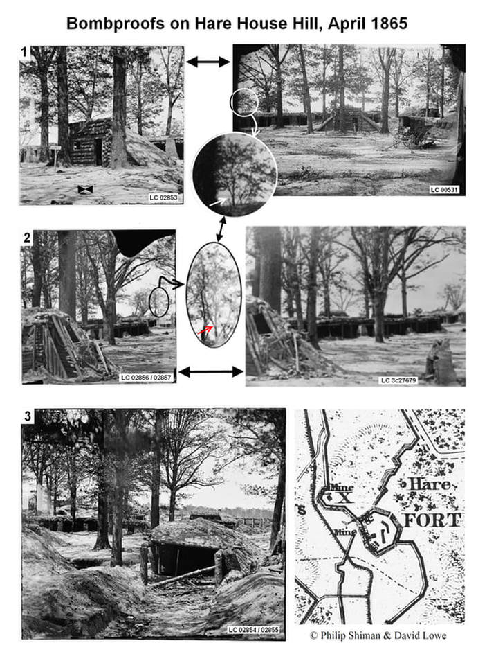
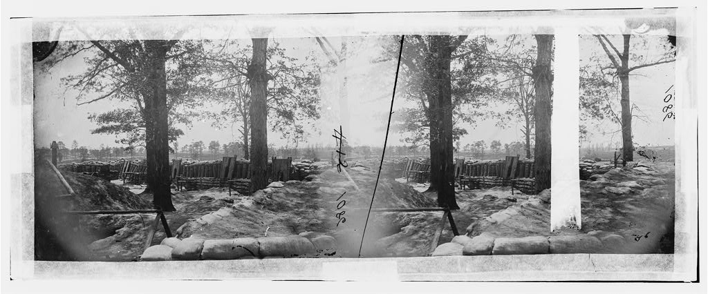
This stereo image has been identified as earthworks at Fort "Stedman." Dr. Shiman has convincingly matched image details with the Army engineers' plan of Battery Ten (X) and cross-referenced these details with other photographs taken in the vicinity. It is clear that the image was taken from the rear of Battery Ten, looking toward the Confederate lines at Colquitt's Salient. When Confederates assaulted this portion of the Union lines before dawn of March 25, they first penetrated Union lines here at Battery Ten and then entered adjacent Fort Stedman. With careful scrutiny, damage from the March 25th fighting can be discovered in this photograph, along with Union efforts to repair the damage in the weeks before the image was taken. In addition, the appearance of Timothy O'Sullivan's assistant "Vest Man" (Wm. Pywell) posed in the doorway of a bombproof is sufficient (by our way of thinking) to attribute this photograph to O'Sullivan. This stereograph was taken roughly at the same time as others in the Fort Stedman series.
Picture
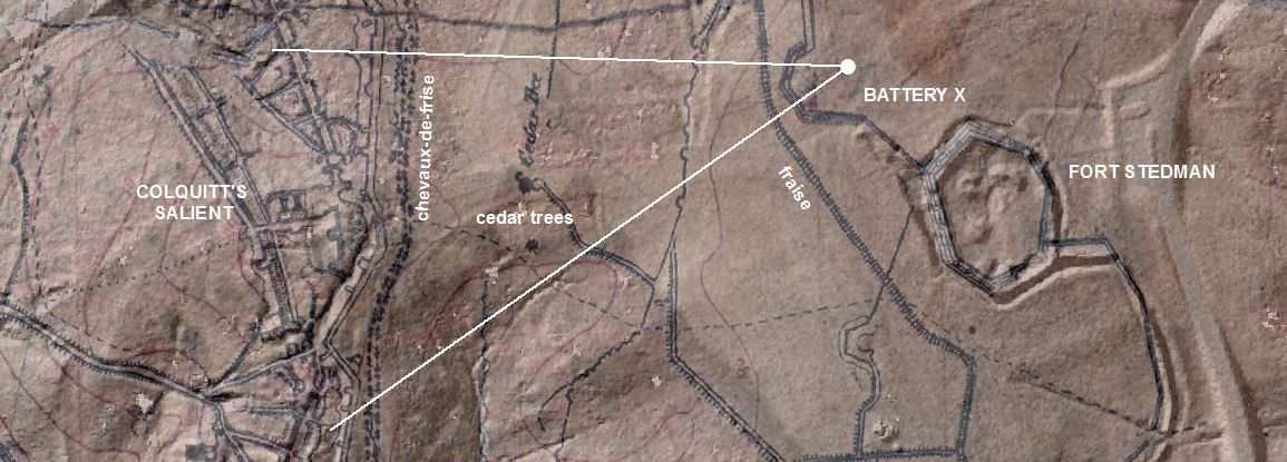
Location of camera for LC00515 stereo view of Battery X, site of first Confederate breakthrough on March 25, 1864
Picture
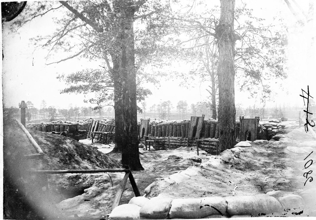
LC 00515. "Petersburg, Virginia. Earthworks [Fort Stedman] in front of Petersburg." Battery X adjacent to Fort Stedman. Image by Timothy O'Sullivan (unattributed).

Picture
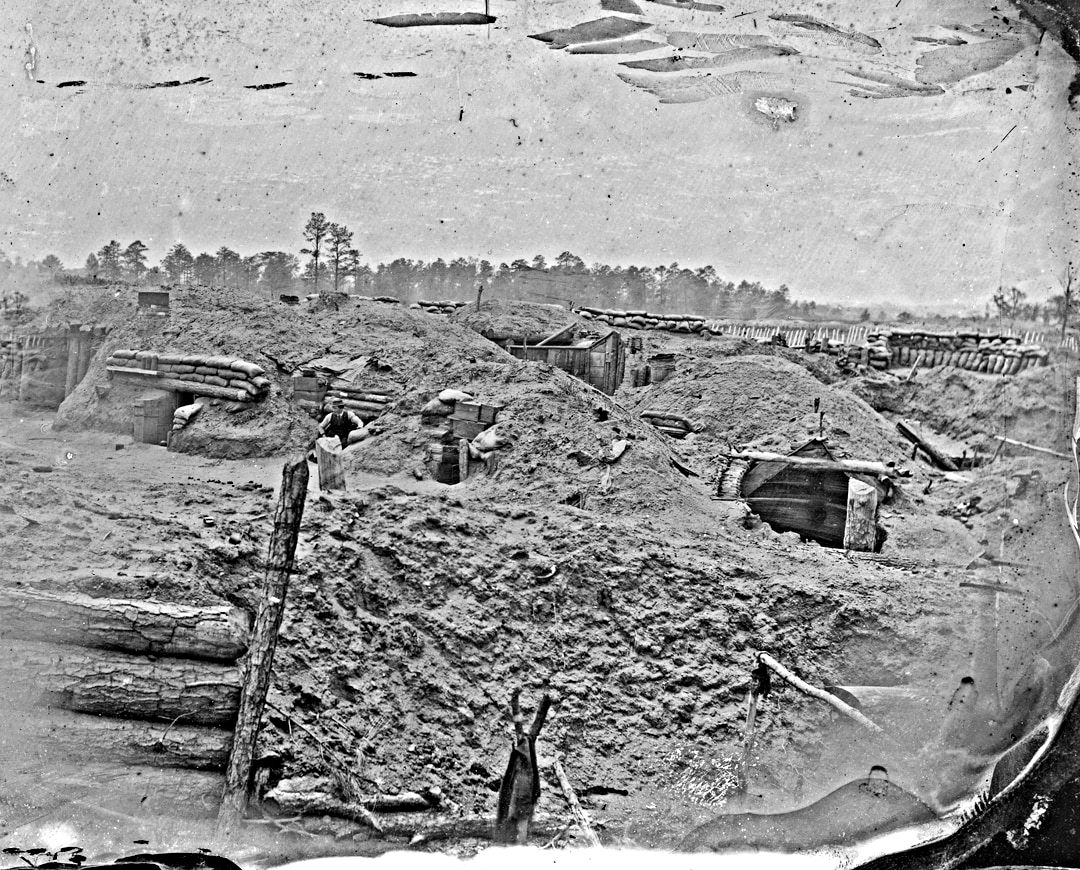
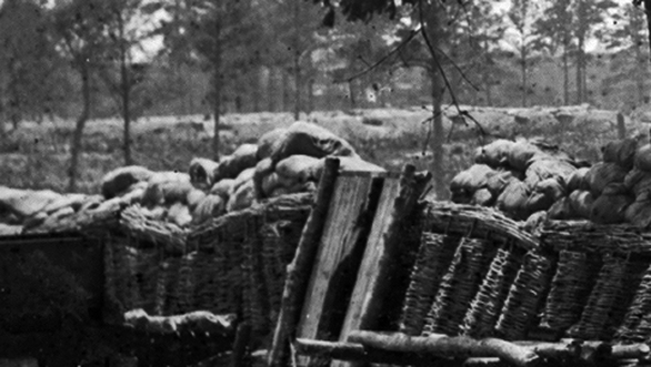
LC 00515 right half of stereo. Dr. Shiman delineates the details found in this photo in the page below. Assistant Pywell posed in doorway of bombproof mid-ground on left.
Picture
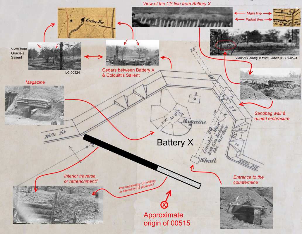
Identification of Battery X photograph by Dr. Philip Shiman 2020

Picture

Updated October 2023

Picture
Proudly powered by Weebly