
Gibbons Properties
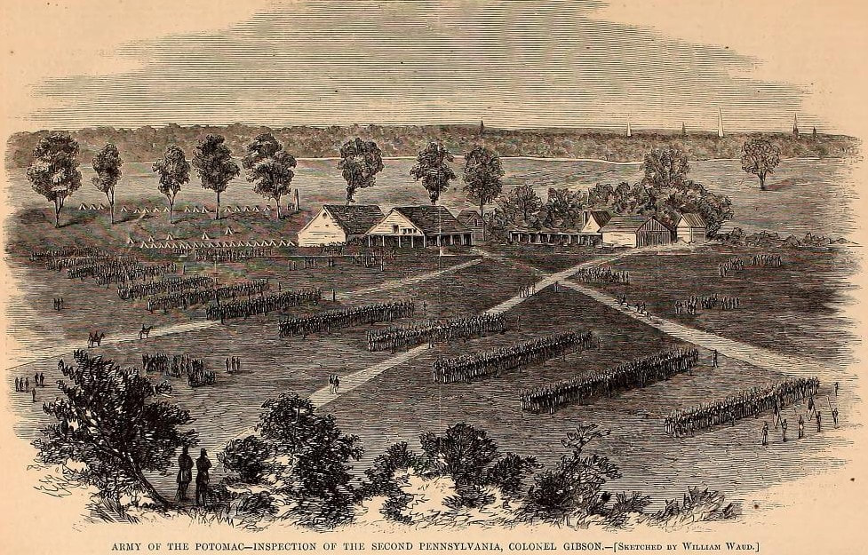 Woodcut of a William Waud sketch published August 13, 1864, for comparison. The buildings included stables for Hare's nearby race course.
Two Gibbons Properties are shown on contemporary maps--a residence and farm located north of the City Point Railroad and an agricultural property south of the railroad on the terrace above Harrison's Creek. This woodcut, from a sketch by William Waud, shows the Gibbon complex south of the railroad. The buildings shown are barns and stables with an overseer's house on the right. The Gibbon family were known on the east coast from Savannah to New Jersey for breeding race horses and had established a business relationship with O.P. Hare who operated the adjacent New Market Race Course. Below is the original William Waud drawing drawn from Friend House hill, looking westerly toward Petersburg's spires in the distance.

LC 20472. William Waud . Sketched from the Head Quarters of the 18th Corps. This Regiment is in the 18th Corps and is one of the largest in the service, numbering when it left Washington over three thousand strong. Colonel A.A. Gibson, Major in the 3rd U.S. Artillery commands the regt.
Dated from historical sources. "[a]fter inspection, dress parade was had, when a representative of Harper's Weekly made a sketch of the regiment which was published in the paper." (Source: History of the Second Pennsylvania ..., by George W. Ward, 1904 rev. ed., p. 86). This sketch corresponds to an engraving published in Harper's Weekly, Aug. 13, 1864.
Illustration published as: "Army of the Potomac : Inspection of the Second Pennsylvania, Colonel Gibson" in Harper's Weekly, v. 8, no. 398 (1864 August 13), p. 516.
Gibbons/Gibben Properties , Prince George Court House Road and adjacent to the Friend property
An Archaeological Overview and Assessment of the
Main Unit, Petersburg National Battlefield, Virginia finds that the Gibbons property:
...had once been a portion of a larger tract; 36 acres were purchased from John Tatum by Francis Rives in 1848. William Gibbons purchased the tract from Rives in 1855. A value of $1008 for buildings in 1856 suggests that Gibbons had structures built in 1855-56. Gibbons was taxed for the 36 acre tract and a nearby one of slightly more than 9 acres during the Civil War, but buildings previously valued at $1008 were destroyed during the siege. The Gibbons farm was thus occupied for only a decade between 1855 and 1865, although the 1942 master plan map indicates twentieth-century activities on the property.
Blades logically assumed that the 36 acre property on Harrison Creek was a farmstead and continued:
...It would appear that the Gibbons house was erected in 1856 and occupied for less than a decade prior to its destruction during the Civil War siege. The farm and three structures were marked "Gibbon" on the 1863 Campbell map (Figure 4.4). The site was labeled "Ruins" on the 1864 Union Engineers map (Figure 4.5). Three structures or ruins are indicated on the Michler map (Figure 5.3) but no name is attributed to the site. The 1942 Master Plan map (Figure 4.13) indicates that a boxwood nursery was located on the property.
The other, 9 acre, Gibbons property, also assumed to be a house, was described:
... A house is shown on the low (40-50 foot) Chowan terrace above Harrison Creek below the bluff of the 100-foot terrace on both the 1863 Campbell map (Figure 4.4) and Union Army Engineer map (Figure 4.5). The house is not labelled with the name of an owner or tenant on the 1863 map, but is labelled "Gibbon" on the 1864 Union map and "Gibben" on the 1867 Michler map (Figure 5.1). The Friend house is labelled "Gibbon (or Friend)" on the 1864 map.
This house was probably associated with the Friend plantation, and may have served as the residence of a plantation overseer. The 1837 County map shows four structures labelled "Quarter"—probably indicative of slave quarters—at this location between Harrison Creek and the newly-constructed City Point Rail Road. A farm road leading from the boundary lane between the Jordan and Friend houses down the bluff to the City Point Road was shown adjacent to this structure on the 1863 and 1864 maps. The 1863 shows farm fields surrounding the terrace house, which lay on lands that had been a portion of the "White Hill" estate since the late eighteenth century.
The 1865 land tax records indicated that $2000 of a total buildings value of $3240 had been deducted for the destruction of buildings during the siege (PG Co. Land Tax 1865), which clearly indicates that structures other than the Friend dwelling had stood on the plantation.
The tax and map information hasn’t changed, but the interpretation of the property as a smaller, slave-holding farm has to change in light of new research. Multiple advertisements in Richmond newspapers placed by O. P. Hare, a nearby land owner, brought to light that William H. Gibbons was the owner of race horses that raced at Hare’s Newmarket course.
https://virginiachronicle.com/cgi-bin/virginia?a=d&d=DD18550509.1.2&srpos=1&e=------185-en-20-DD-1--txt-txIN-%22O.+P.+Hare%22------
https://virginiachronicle.com/cgi-bin/virginia?a=d&d=DD18550425.1.2&srpos=2&e=------185-en-20-DD-1--txt-txIN-%22O.+P.+Hare%22+Gibbons------
https://virginiachronicle.com/cgi-bin/virginia?a=d&d=DD18561021.1.2&srpos=11&e=------185-en-20-DD-1--txt-txIN-%22O.+P.+Hare%22+Gibbons------
Some of the notices peg Gibbons as “from New Jersey”. Further research reveals that William H. Gibbons was the wealthy scion of a family with deep roots in American racing. The family ‘s original prominence was in Savannah, but by the time of the Civil War, they were based in New Jersey.
http://www.jerseyhistory.org/findingaid.php?aid=1302#Summary:
http://mushroom-clues.bluarcher.com/lb-gibbonsfamilyplot.htm
https://www.moaf.org/publications-collections/museum-collection/carver_finding_aid
It would appear that the Gibbons property in Prince George county was associated with the Newmarket race course. Gibbons was clearly associated with O.P. Hare through racing. A William Waud drawing of buildings on the 9 acre parcel Gibbons land shows two large barns and another roofed but unenclosed row of horse stalls along with other buildings where chimneys imply use as dwellings.
We do not know the nature of the buildings shown on maps at the Prince George Courthouse Rd. location. It is likely that these were also related to racing or stabling. Both enslaved and free individuals probably lived at both locations, but this was not the residence of the Gibbons family, who were absentee owners. This new information explains why William H. Gibbons is on record in the Prince George county tax rolls, but is not found on the 1860 Federal census for Prince George.
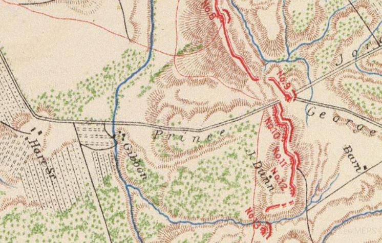
Detail of Military Atlas plate 40, Rumsey Map Collection, showing location of a Gibbon house intersection of Prince Georges Road and Harrison's Creek.
