The Petersburg Project
  • Home
    • About Us
  • Blog and Updates
  • Postwar Visit to the Battlefields 1866
  • Civil War Combat Trenching
  • Views of the City of Petersburg
    • Petersburg Panorama 1865
    • Steeples of Petersburg
    • Petersburg Mill Photographs
  • The Mine Explosion and its Crater
  • Petersburg in Pencil and Ink
    • Alfred R. Waud, Special Artist at Petersburg >
      • Waud Drawing of 5th Corps Fortifications
    • William Waud, Special Artist
    • Charles H. Chapin, Special Artist
    • Joseph Becker, Special Artist at Petersburg
    • Edwin Forbes, Special Artist at Petersburg
    • Winslow Homer, Special Artist
    • Edward Mullen, Special Artist at Petersburg
    • Andrew W. Warren, Special Artist
    • Enlisted Artists >
      • Charles Wellington Reed
      • Andrew McCallum
      • Francis Knowles
      • James William Pattison
      • Herbert Valentine
      • Howard A. Camp
  • Petersburg Photographs --So Many!
    • Dimmock Battery 5 Photographs >
      • Working with Photographs
    • City Point
    • City Point Wharf Explosion, Aug. 9, 1864
    • Fort Rice?? We don't think so!
    • Federal Picket Line, Jerusalem Plank Road
    • Egbert Guy Fowx, Photographer at Petersburg
    • Timothy O'Sullivan, Photographer at Petersburg >
      • Harrison's Creek USCT Camps
      • Fort Morton and Baxter Road Group
      • Fort Haskell Panorama and Bomb Proofs
      • Fort Stedman Group
      • Gracie's Salient Group
      • Camp of the 50th N. Y. Engineers
    • David Knox, Photographer at Petersburg
    • William Redish Pywell, Photographer at Petersburg
    • John Reekie, Photographer at Petersburg
    • Thomas C. Roche, Photographer at Petersburg
    • Andrew J. Russell, Photographer at Petersburg >
      • "Fort Mahone" CS Batteries 25 & 27
  • U. S. Military Railroad
    • Terminus of Military R. R. at City Point
    • City Point to Clark's Station
    • Pitkin's Station to Shooting Hill
    • Hancock's Junction/Jerusalem Plank Road
    • Parke's Station
    • Warren's Station
    • Patrick's Station
  • Topographical Engineers -- Our Heroes
    • Grand Medicine Pow-wow
    • Michler's Reports from Topographical Department
    • John E. Weyss, Cartographer
    • William H. Paine, Cartographer
    • Gilbert Thompson
    • Albert Hanry Campbell, C.S.A. Cartographer
  • Confederate Maps
    • Confederate Defenses 1862
    • Gilmer-Campbell Maps, 1864
    • Stevens Map July 1864
    • Fields of Fire
    • Campbell Dinwiddie County 1864
    • Coit's map of the Crater Battlefield
  • Federal Maps
    • Army of the Potomac, Routes of the Corps to Petersburg
    • June 9 1864, Kautz Attack
    • June 18, 1864-Federal Engineers Maps
    • June 18, 1864, 18th Corps
    • June 19, 1864, Engineers Map
    • June 21, 1864, Federal Engineers Maps
    • June 22, 1864. Second Corps at Jerusalem Plank Road
    • June 29, 1864. Dept of VA and NC
    • June 30, 1864 -- XVIII Corps Map
    • June-July, Undated Federal Engineers Map-
    • July 29, 1864, Engineers Map, Annotated
    • July 1864 Map of XVIII Corps Lines
    • Crater, Native American Perspective of the Crater
    • August 1864, Michie Map - Bermuda 100
    • August 28, 1864, Michler Map
    • Aug.-Nov. 1864 Two Base Maps
    • September 13, 1864, Recon Map
    • Sept. 13-Oct.25 versions. Redoubts and Batteries
    • September 30, 1864, Warren Map
    • October 1864, Two IX Corps Maps
    • October 20, 1864. Benham's map of defenses of City Point
    • Nov. 2, 1864, Army of the Potomac
    • 1864, Coast Survey Map of Petersburg
    • June 1864-April 1865 Map of Federal & Confederate Earthworks
    • Michler Map Series 1865-1867
    • 1864-1867, Michler-Weyss, Siege of Petersburg
    • 1865-1867, Manuscript Survey Maps
    • 1871, Map of Recapture of Ft. Stedman
    • 1881, Boydton Plank Road
  • Confederate Forts and Batteries
    • Dimmock Line >
      • Priest Cap
      • French Rifle Pits
    • Fort Clifton
    • "Fort Mahone" CS Batteries 25 & 27
    • Confederate 8-inch Columbiad
    • Leadworks
  • Federal Forts and Batteries
    • Union Battery Ten (X)
    • Fort Alexander Hayes
    • Fort Avery
    • Fort Conahey
    • Fort Davis & Battery XXII
    • Fort Fisher
    • Fort Meikel --Photographic Views
    • Fort Morton
    • Fort Patrick Kelly
    • Fort Sedgwick, better known as Fort Hell,
    • Fort Wadsworth -- the Evolution
    • Fort Willcox or Battery XVI
  • Battlefield Features
    • Aiken House
    • Armstrong's Mill
    • Avery House
    • Bailey/Johnston Farm
    • Blandford Church
    • Broadway Landing, Appomattox River
    • The Crater
    • Cummings House
    • Dams and Inundations
    • WW Davis Farm
    • Dunn House
    • Friend House >
      • View from Friend House toward Gibben complex and Petersburg
    • Gibbons Properties
    • Globe Tavern / Weldon Railroad
    • Gregory House
    • Griffith Farm
    • Gurley House
    • Hare House Hill
    • The "Horseshoe"
    • Jerusalem Plank Road
    • Jones House
    • Jordan House
    • Newmarket Racecourse
    • Pegram's Farm
    • Peebles Farm, Pegrams Farm, Poplar Springs Church
    • Shands House
    • Taylor Farm >
      • The Ice House
      • Surviving Taylor Barn
    • Williams House
  • Signal Towers and Trees
    • Some Operations of the Signal Corps at Petersburg
  • Archeology
    • Geology of the Crater
    • Fieldwork -- Petersburg
    • Civil War Sinks
    • Deserted Confederate Camp
    • Gracie's Countermine
    • LIDAR Forts and Batteries
  • Articles, Papers, Presentations
    • Shiman: A Note on Maps
    • The Siege Landscape: Through Fire and Ice at Petersburg
    • "The Rebel in the Road"
    • "A Strange Sort of Warfare Underground"
    • Lost Trenches of Petersburg: June 17
    • Between the Lines
    • Combat Trenching: An Introduction
    • Lowe -- Post-War Topographical Survey
    • Civil War Maps and Landscapes -- Observations
  • Kittens, Puppies & Ponies
  • Executions!
  • Notes on Leveled Earthworks
  • Depot Hospital at City Point
  • Pontoon Bridges
  • The Great Pontoon Bridge Across James River
  • Captain Robert Davis CSA
  • Cock Fight at Ninth Corps Headquarters

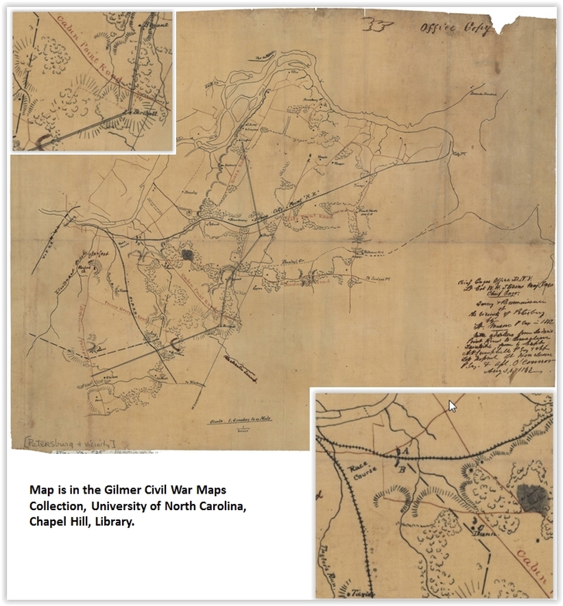
August 1862 Map of Confederate Defenses of Petersburg

This map, prepared for the Chief Engineers Office, Department of Northern Virginia, is the earliest map we know of depicting the schematic layout of the Confederate defenses, eventually called the "Dimmock Line", east of the city of Petersburg.  In the summer of 1862, there may have been three batteries already constructed- two labeled "A" and "B" guarding the road and railroad approaches from City Point, and another labeled "C", on high ground just north of the Dunn house.  We don't know what is represented by the double lined feature that runs from the Arlington house on the bluff overlooking the Appomattox River, south to the Baylor house, then to the Bryant house and the Birchett house before taking a swing southwest toward the Jerusalem Plank Road.  Could this be a plan for an outer line of defensive works that was never constructed?  On June 15, 1864, Federal troops  faced a line  of hastily constructed rifle pits thrown up across the City Point Road near Baylor's farm.  The rifle pits were fronted by a line of abattis and backed by Edward Graham's four gun Petersburg Battery (Howe 1988:22), all of which presented a serious obstacle to the U. S.  advance.
Picture
Picture
Proudly powered by Weebly