
Hare House Hill -- Key to the Confederate Defense of Petersburg on June 17-18, 1864, Focus of the Confederate Attacks of March 25 and the battle of Fort Stedman
"On the right of the line, was an elegant residence, formerly occupied by Mr. O. P. Hare, a southern sporting gentleman of wealth, who was "not at home" when we arrived. The men, in their customary style of protecting secesh property, procured some very elegant horse-trappings and equipments from his establishment. His house and the adjacent building were completely riddled with shot and shell. His furniture was sadly "demoralized," and soon distributed along the works. Costly stuffed chairs, and sofas of plush and damask, furnished yankee soldiers luxuriant repose; and a fine rosewood piano, which a rebel-shell had "played upon," was made to do duty in a portion of the works we had thrown up across his garden. (Houghton. 17th Maine Regiment 1866:203,204)
|
|
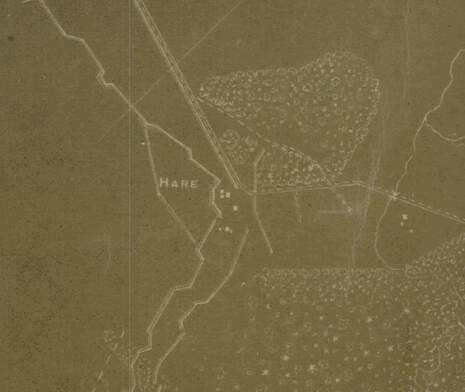
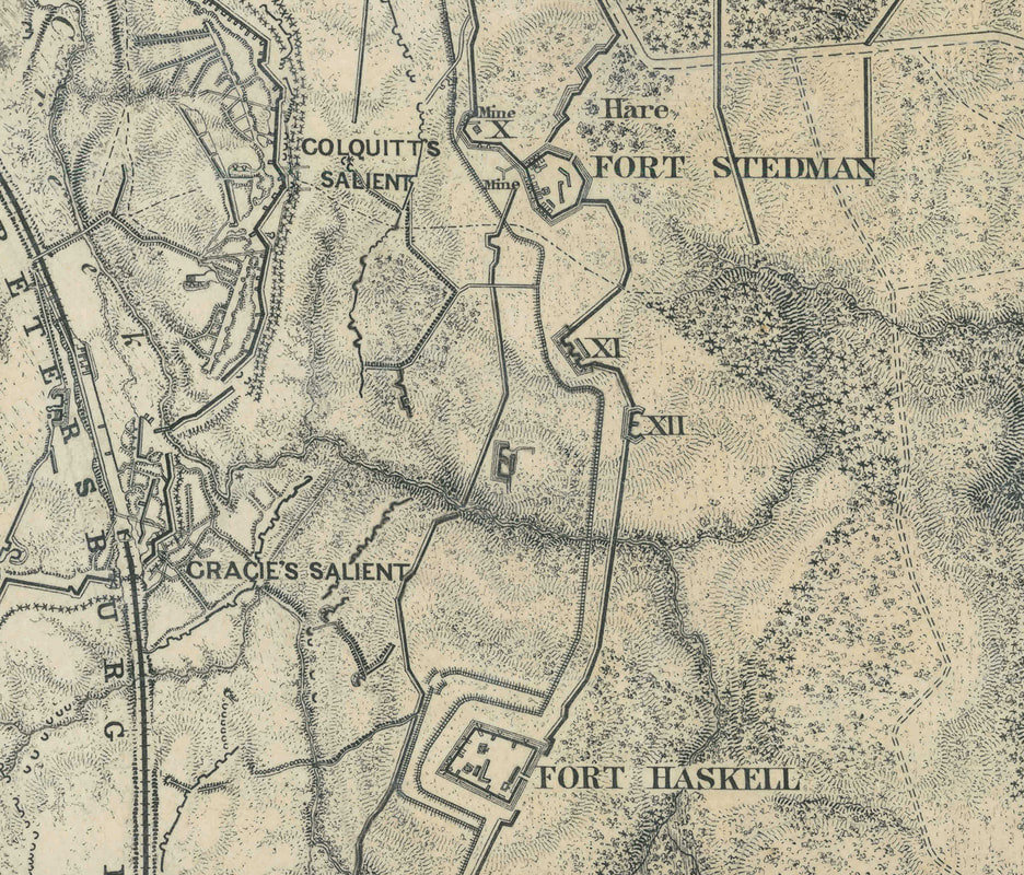
Detail on the left shows Hare Buildings that were standing in early July 1864. Detail on right shows extensive reworking of fortifications and construction of Forts Stedman and Haskell by 1865. The Hare buildings at this point had been incorporated into the Union lines as building materials.
Hare house site: "The plantation of Richard Bate appears in the 1782 land tax. The sketch of the dwelling indicated projecting end chimneys, a central doorway, and a projecting cellar bulkhead and porch along one long side. ... Otway Hare purchased the plantation in 1837 and resided on the property with his family when the Union Army of the Potomac attacked the Petersburg defenses in June 1864. As the attack progressed, the Hare house fell behind the advancing Union lines. ... The noted Civil War illustrator Alfred Waud drew a pencil sketch of the front of the Hare house in the summer of 1864, a sketch that seems to show the effects of both shelling and pillaging. The Michler map indicates that the house stood just behind the Union siege line, between Fort Stedman and the Prince George Court House Road. The house and adjacent buildings disappeared during the siege, probably shortly after Waud completed his sketch in the summer of 1864. Hare did not reoccupy the plantation, but resided in Petersburg after the war, where he managed a pharmacy that he had owned since 1855."
-- An Archaeological Overview and Assessment of the Main Unit, Petersburg National Battlefield, Virginia, National Park Service, 2001.
"On the night of the [June] 21st , the Battery withdrew from this position to go into position at the Hare House on the extreme right, and just south of which Fort Stedman was afterward built. The house was named after the proprietor of the race course. Here the men built breastworks that were only about four hundred yards from the rebel line, and hence we were in uncomfortably close quarters to the enemy. One-second fuses only could be used...... About midway between our line and the enemy's, stood a barn. It had nearly all been taken down to the main floor, and on this floor lay about eighty bushels of corn" (Roemer 221).
Maps and regimental accounts make clear there were a number of outbuildings associated with the Hare estate:
Alfred R. Waud drawings -- Hare House Hill
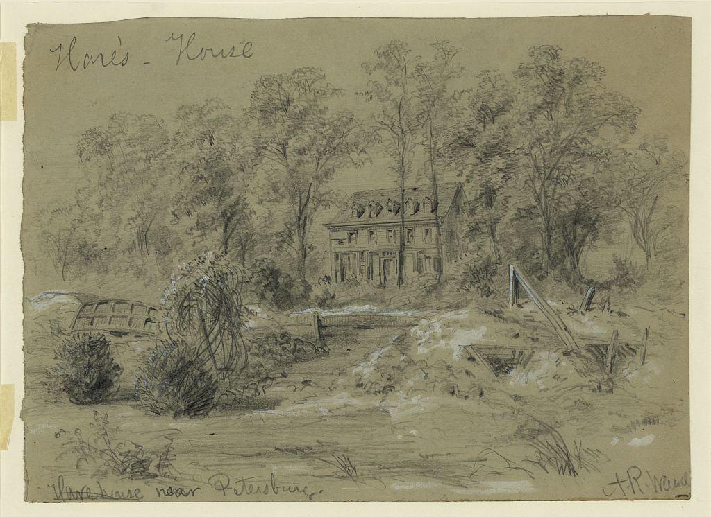
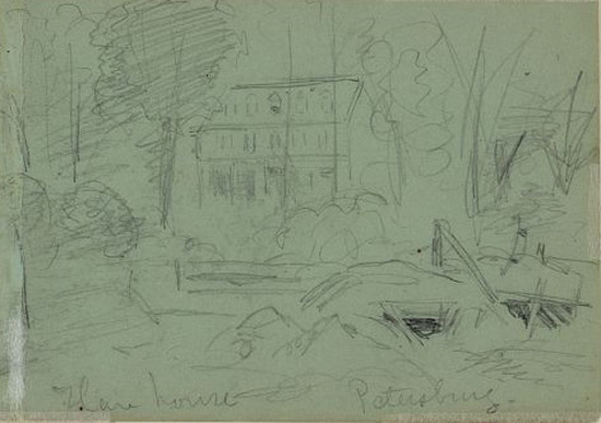
"Hare's House," drawing by A. R. Waud [DRWG/US - Waud, no. 294 (A size)]
"Hare House, Petersburg," drawing by A. R. Waud [DRWG/US - Waud, no. 909 verso (A size)]
|
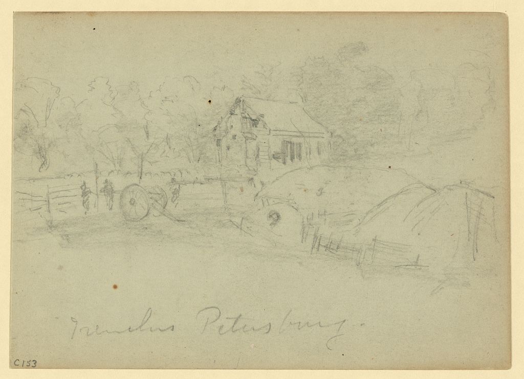
"Trenches, Petersburg," drawing by A. R. Waud [DRWG/US - Waud, no. 1080 (AA size)] Sketch on Hare House Hill. Hare's barn or other outbuilding in background.
|
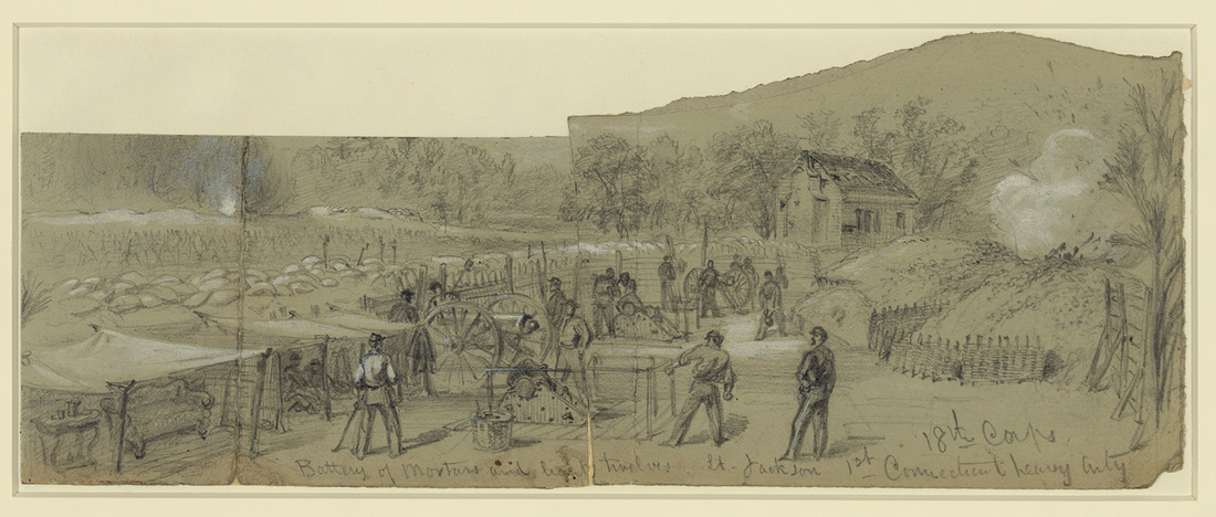
"Battery of mortars and light twelves. Lt. Jackson. 1st Connecticut heavy Arty. 18th Corps," drawing by A R. Waud [DRWG/US - Waud, no. 170 (A size)] Notice settee and end table from Hare's house under canvas on the left.
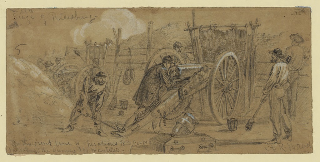
"Siege of Petersburg," drawing by A. R. Waud [DRWG/US - Waud, no. 197 (A size)] Inscribed lower left: "on the front line of operations 18th Corps/protecting the gunners by mantelets."
|
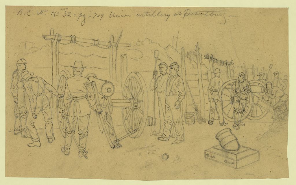
"Union artillery at Petersburg," drawing by A. R. Waud [DRWG/US - Waud, no. 460 (A size)]
|
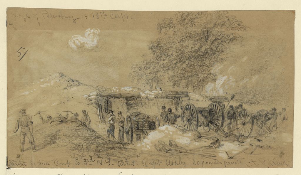
"Siege of Petersburg. 18th Corps. Right section, Comp. E 3rd N.Y. Arty. Capt. Ashby. 20 pounder parrots," drawing by A. R. Waud [DRWG/US - Waud, no. 495 (A size)]
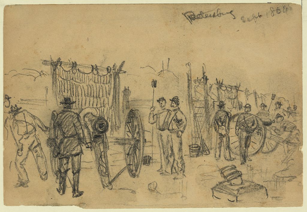
LC 21358. "Petersburg Sept. 1864"
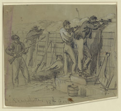 "Sharpshooters 18th Corps," drawing by A. R. Waud [DRWG/US - Waud, no. 359 (A size)] "Sharpshooters 18th Corps," drawing by A. R. Waud [DRWG/US - Waud, no. 359 (A size)]
|
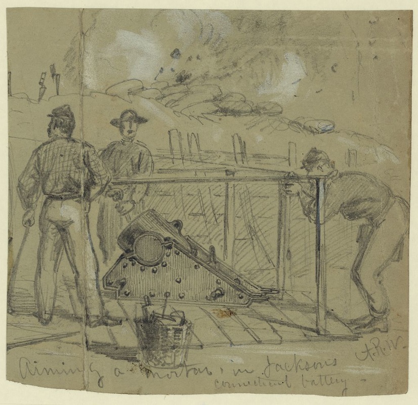
"Aiming a Mortar in Jacksons Connecticut battery," drawing by A. R. Waud [DRWG/US - Waud, no. 451 (A size)]. Note the bayonets placed atop the parapet as aiming stakes.
|
Sharpshooters on the 18th Corps Front: "On some portions of the lines picket firing was soon discontinued. Genl. Warren considered it unnecessary to the safty [sic] of the 5th Corps front, and put a stop to it. The enemy did likewise. But where the practice was in vogue it was very dangerous to be exposed. A common plan of protection was that shown in the sketch, by a wooden tube widening outwards like a miniature embrasure buried in the crest of the rifle pit and protected by sandbags." [Waud's comments on a separate sheet.]
The sharpshooters posted in the house and on the grounds were members of the 1st U.S. Sharpshooters -- the famed "Berdan's Sharpshooters." They left the following account:
"On the 18th, advancing from the line of works taken from the enemy the night previous, our Sharpshooters were posted in and around the premises of 0. P. Hare, a noted Virginia turfite, whose race-course and training grounds called "Newmarket" were soon despoiled of all semblance of their former glories by the tramping of armed men, the galloping of war-like steeds, and the wheeling of heavy batteries. Here our men remained until the night of the 21st, using their rifles faithfully, often within 60 yards of the enemy's rifle pits, at different points along the line. The charge near the Hare House by a Union brigade on the 18th, resulted in disaster, although the Sharpshooters at the house were busily engaged assisting them with their rifles.…
"On the 19th Companies E and G occupied a position in and around the house, the brigade building a line of works across the garden. Hare's house was evidently left by the late occupants in a hurry, as a large amount of books and papers principally referring to sporting items, furniture of different kinds, carpets, etc., were found scattered about. The walls of the building were completely perforated with bullet holes, while larger ones were being daily made by round shot and shell. The windows of the carpeted basement opened on one side in full view of the rebel pits in front, and as the basement itself made a very comfortable rifle pit, with chairs of mahogany to sit on, a number of the riflemen took possession of the same for the day. Among them was Emery Munsell, who was seated in an arm-chair with his 28-pounder, making long-range shots, several of which were thrown at random towards Petersburg, in hopes of attracting the notice of the editor of the [Petersburg] Express while seated in his evidently uneasy chair, where he could have found a truthful item about the Sharpshooters, as an equivalent to the lying one he invented on the death of Durkee before Yorktown; as the Union Sharpshooters were actually established in a "carpeted rifle pit" (but furnished by the enemy) with "comfortable arm-chairs to sit in," and "mahogany tables to eat off of;" although the wine cellar which was close at hand, contained naught but empty bottles.
"While the New Hampshire captain (Andrews), and Wisconsin lieutenant (Stevens), were seated at one of Hare's tables at half past six o'clock the morning of the 19th, eating their simple breakfast of hard-tack and coffee, the rebel bullets whizzed through the windows over their heads into the opposite wall, showing conclusively that they had range of the place although they did no harm, yet succeeded in raising considerable dust inside as the broken plaster fell to the floor. The Sharpshooting party, however, silenced them in the course of the morning."
-- Capt. C. A. Stevens, Berdan’s United States Sharpshooters in the Army of the Potomac, 1861-1865 (St. Paul, MN: The Price-McGill Company, 1892), 456-58.
Fun in the Hare House. Many of the men occupied the Hare house. In the parlor was a piano which was played by the boys to the accompaniment of the music of cannon and musketry. Some donned women's clothing found in the closets and made merry, dancing a cotillion as shells tore through the roof and bullets broke the glass in the windows. One boy was struck in the face by a minie ball while he sat in a rocking chair, just after he had said: "What do you think the folks at home would say to this?" N. P. Cutler wrote in greater detail this story for the Boston Journal of Jan. 24, 1893 (p.288).
History of the First Regiment of Heavy Artillery, Massachusetts Volunteers, Formerly the Fourteenth Regiment of Infantry, 1861-1865 – Alfred Seelye Roe, Charles Nutt
Photographs of Hare House Hill by Timothy O'Sullivan with William Pywell
|
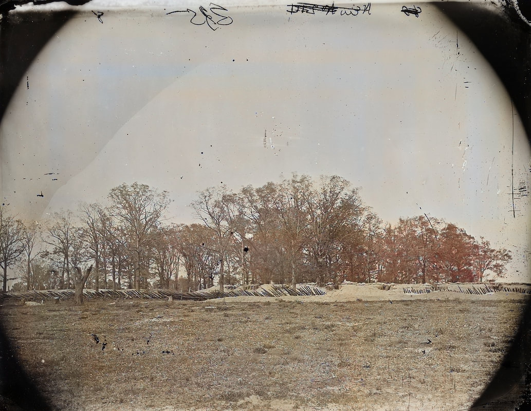
LC00527 detail. "Petersburg, Virginia. Bomb-proof in front of Petersburg," left half of stereo view by O'Sullivan and Pywell (unattributed) of Hare House Hill taken in April 1865. Stedman is in the grove of hardwood trees. The house stood to the right of the fort but had largely disappeared by this point. The "Y" snag at the far left is visible in several other photos. This is basically the ground over which Federal troops counterattacked on March 25 to seal off and eliminate the Confederate penetration. If there is doubt of the O'Sullivan connection, William Pywell is posed in the doorway to the bombproof. This is one of a series of stereographs taken from Fort Haskell, the bombproofs behind Haskell, and from Gracie's Salient. Considered together, these photographs show much of the Fort Stedman March 25th battlefield.
|
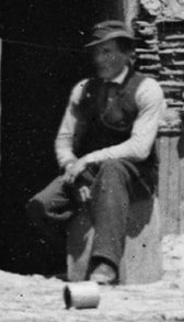
Pywell posed in the doorway of bombproof shown by LC 00527.
|
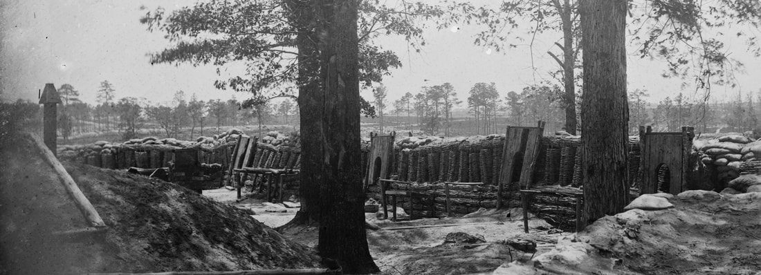
LC 00532 detail. "Petersburg, Virginia. Fort Meikle (named for Lt. Col. George Meikle, 20th Ind. Inf.) in front of Petersburg." One of the most egregiously mislabeled stereo views in the entire LOC Petersburg collection. This is a view of Fort Stedman on Hare House Hill taken from Fort Haskell, 600 yards to the south. Fort Haskell held firm during the March 25th 1865 incursion by Confederate troops. This is another of the O'Sullivan-Pywell series. Please note the "Y" snag at the far left of the detail. The hardwood grove is perhaps the only example of its kind along this section of the Petersburg lines. Why did they let the trees stand when so many thousands of acres were denuded? It was very hot; the soldiers liked the shade?
LC 00540 detail. "Petersburg, Virginia. Fort Stedman in front of Petersburg," stereo view from inside the fort looking out toward Colquitt's Salient, whence came the Confederate assault at dawn, March 25th.
|
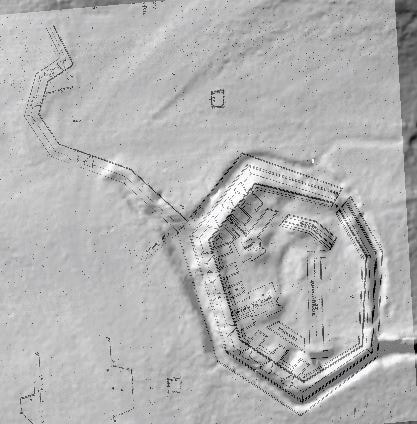
A Union engineers' plan of Fort Stedman overlays a Lidar elevation model, showing surviving features. The Confederate attackers on March 25, 1865, first overran Battery 10 (top left), which has largely disappeared over the years.
|
Last Updated 07/22/2022
