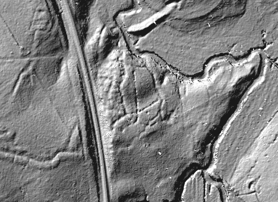
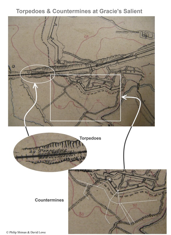
Paying close attention to details on historic maps is important! Archeologists will be bringing ground penetrating radar (GPR) during the winter survey season to explore underground survivals of a Confederate countermine at Gracie's Salient. We found the countermine by close examination of a manuscript map from the Library of Congress collections, by reexamining the documentation, by overlaying an old map on top of a new map, and by trooping out to look at the site firsthand.
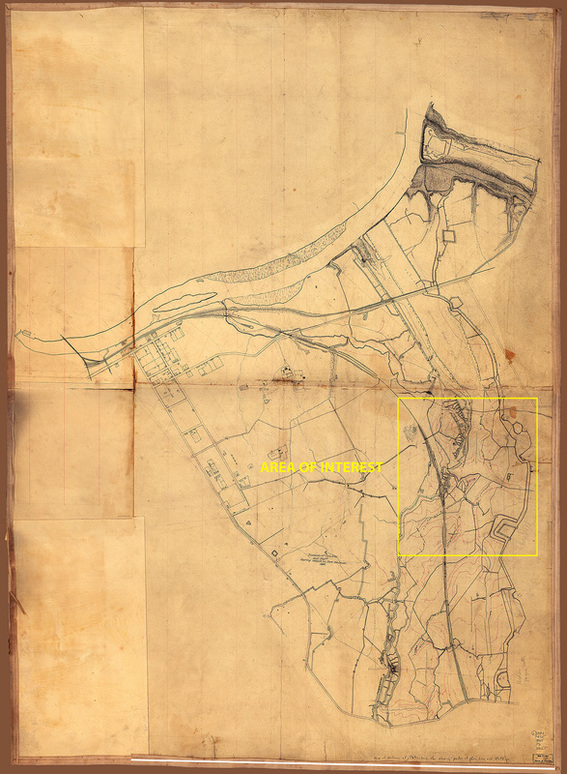
This is a manuscript map of the eastern front of the Petersburg defenses, produced by Federal topographical engineers shortly after the end of the war. It depicts the area south of the Appomattox River, north of Baxter Road near the Crater, east of Jerusalem Plank Road, and west of the main Federal line of siegeworks.
The map can be found at the Library of Congress. (http://hdl.loc.gov/loc.gmd/g3884p.cw0607200)
The map has been titled by archivists as "Map of defenses of Petersburg, Virginia, showing the position of General Lee and his staff during the attack on Fort Stedman, March 25, 1865."
The map can be found at the Library of Congress. (http://hdl.loc.gov/loc.gmd/g3884p.cw0607200)
The map has been titled by archivists as "Map of defenses of Petersburg, Virginia, showing the position of General Lee and his staff during the attack on Fort Stedman, March 25, 1865."
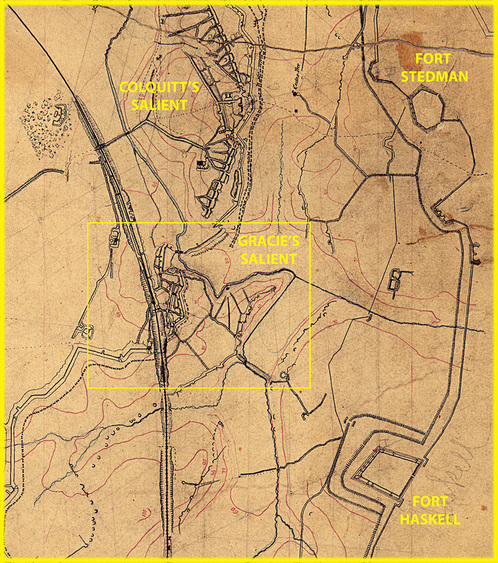
The manuscript map was likely done by the crew of John E. Weyss, who was Michler's chief field surveyor. It is a very detailed pen and ink drawing, showing Confederate and Union fortifications in black. Contour intervals are suggested in red ink. Streams are thin black squiggles.
The map was surveyed by triangulation. A surveyor set up his instrument (a theodolite) at various stations established along the earthworks. He aimed his telescope at known points in the distance and recorded a compass bearing and angle transect derived from a survey baseline. The stations are marked on the map with a penciled triangle and lettered A-K. From each station, pale pencil lines radiate out across the map, representing the transects recorded in the surveyor's notebook. These measurements provided the "skeleton" for the body of the map.
Other landmarks are shown. For example, "Three Pines," or a "Cedar Tree" that can be identified in some of the historic photographs of this area.
Zooming closer into Gracie's Salient, other details are revealed.
|
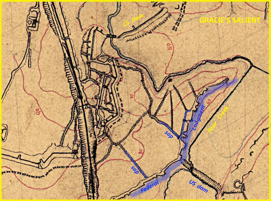
After June 18, the Federals established a lodgement on the steep west bank of Poor Creek and built a dam to connect this advanced position with their main line east of the Creek. The Confederates countered by building a dam of their own to flood the low ground in front of their works and behind a portion of the Union line.
From documents in the Official Records, we know that Federals advanced two saps toward Confederate lines to provide cover for their sharpshooters. By late July, the two lines were close enough exchange hand grenades. The Confederates started mining operations to intercept and destroy the Union saps. |
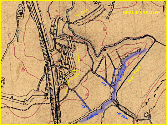
Confederate engineer Hugh Thomas Douglas was assigned the duty of digging a countermine, which he began on July 22 by sinking the first shaft.
Over the next two weeks, Douglas sunk a second shaft, extended galleries forward, and then connected these galleries with a lateral tunnel that extended along the whole front of Gracie's Salient. This was a classic defensive tactic in siege warfare to prevent your line from being undermined.
The faint pencil marks on the original map (here highlighted in yellow) tell the story.
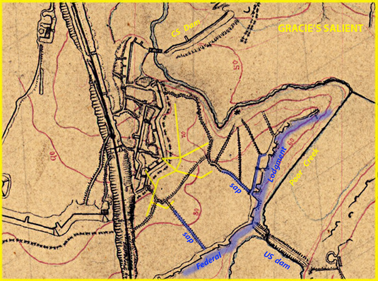
Spurred on by the Battle at the Crater, engineer Douglas fought mud, water, and threatened collapse to complete three offensive galleries to intercept the Union sappers. Douglas excavated chambers at the end of two of the galleries and charged each mine with 425 pounds of gunpowder. He reported that on "August 5, at 6.30 o’clock the mines at Gracies were fired and blown up," evidently beneath the Union sap rollers. Douglas thought the operation a complete success.
After this harrowing duty was discharged, Douglas refused to go underground again. He was thereafter relieved of his command. Mining and countermining continued on both sides. We were eager to discover if we could find evidence of the shafts and countermine on the ground at Gracie's.
After this harrowing duty was discharged, Douglas refused to go underground again. He was thereafter relieved of his command. Mining and countermining continued on both sides. We were eager to discover if we could find evidence of the shafts and countermine on the ground at Gracie's.
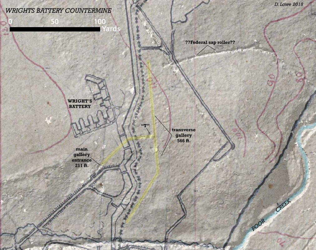
This map emphasizes the penciled lines on the Michler manuscript map that we believe show the countermine at Wright's Battery. LiDAR and ground-trothing have revealed areas where the galleries appear to have collapsed. Unfortunately, Wright's Battery itself is no longer intact; it survives as a rather shapeless pile of rubble at the edge of the cemetery.

