The Petersburg Project
  • Home
    • About Us
  • Blog and Updates
  • Petersburg Panorama 1865
  • Steeples of Petersburg
  • The Mine Explosion and its Crater
  • Petersburg in Pencil and Ink
    • Alfred R. Waud, Special Artist at Petersburg >
      • Waud Drawing of 5th Corps Fortifications
    • William Waud, Special Artist
    • Charles H. Chapin, Special Artist
    • Joseph Becker, Special Artist at Petersburg
    • Edwin Forbes, Special Artist at Petersburg
    • Winslow Homer, Special Artist
    • Edward Mullen, Special Artist at Petersburg
    • Andrew W. Warren, Special Artist
    • Enlisted Artists >
      • Charles Wellington Reed
      • Andrew McCallum
      • Francis Knowles
      • James William Pattison
      • Herbert Valentine
      • Howard A. Camp
  • Petersburg Photographs --So Many!
    • Working with Photographs
    • City Point
    • City Point Wharf Explosion, Aug. 9, 1864
    • Fort Rice?? We don't think so!
    • Federal Picket Line, Jerusalem Plank Road
    • Egbert Guy Fowx, Photographer at Petersburg
    • Timothy O'Sullivan, Photographer at Petersburg >
      • Fort Morton and Baxter Road Group
      • Fort Haskell Panorama
      • Fort Stedman Group
      • Gracie's Salient Group
      • Bombproofs behind Fort Haskell
      • Camp of the 50th N. Y. Engineers
    • David Knox, Photographer at Petersburg
    • William Redish Pywell, Photographer at Petersburg
    • John Reekie, Photographer at Petersburg
    • Thomas C. Roche, Photographer at Petersburg
    • Andrew J. Russell, Photographer at Petersburg >
      • "Fort Mahone" CS Batteries 25 & 27
  • U. S. Military Railroad
    • Terminus of Military R. R. at City Point
    • City Point to Clark's Station
    • Pitkin's Station to Shooting Hill
    • Hancock's Junction/Jerusalem Plank Road
    • Parke's Station
    • Warren's Station
    • Patrick's Station
  • Maps and Topogs
    • Grand Medicine Pow-wow
    • Michler's Reports from Topographical Department
    • John E. Weyss, Cartographer
    • William H. Paine, Cartographer
    • Gilbert Thompson
  • Confederate Maps
    • Confederate Defenses 1862
    • Gilmer-Campbell Maps, 1864
    • Stevens Map July 1864
    • Fields of Fire
    • Campbell Dinwiddie County 1864
    • Coit's map of the Crater Battlefield
  • Federal Maps
    • Army of the Potomac, Routes of the Corps to Petersburg
    • June 18, 1864-Federal Engineers Map
    • June 18, 1864, 18th Corps
    • June 21, 1864, Federal Engineers Map
    • June 22, 1864. Second Corps at Jerusalem Plank Road
    • June 29, 1864. Bermuda Hundred
    • June 30, 1864 -- XVIII Corps Map
    • June-July, Undated Federal Engineers Map-
    • July 1864 Map of XVIII Corps Lines
    • Crater, Native American Perspective of the Crater
    • August 28, 1864, Michler Map
    • September 13, 1864, Recon Map
    • September 30, 1864, Warren Map
    • October 1864, Two IX Corps Maps
    • Nov. 2, 1864, Army of the Potomac
    • 1864, Coast Survey Map of Petersburg
    • NEW 1865-1867, Manuscript Survey Maps
    • 1864-1867, Michler-Weyss, Siege of Petersburg
    • 1865-1867, Michler Map Series
    • 1871, Map of Recapture of Ft. Stedman
    • 1881, Boydton Plank Road
  • Confederate Forts and Batteries
    • Dimmock Line >
      • Priest Cap
      • French Rifle Pits
    • Fort Clifton
    • "Fort Mahone" CS Batteries 25 & 27
    • Confederate 8-inch Columbiad
    • Leadworks
  • Federal Forts and Batteries
    • Battery X
    • Fort Alexander Hayes
    • Fort Avery
    • Fort Conahey
    • Fort Davis & Battery XXII
    • Fort Fisher
    • Fort Meikel --Photographic Views
    • Fort Morton
    • Fort Patrick Kelly
    • Fort Sedgwick, better known as Fort Hell,
    • Fort Wadsworth -- the Evolution
    • Fort Willcox or Battery XVI
  • Battlefield Features
    • Aiken House
    • Armstrong's Mill
    • Avery House
    • Bailey/Johnston Farm
    • Blandford Church
    • Broadway Landing, Appomattox River
    • The Crater
    • Cummings House
    • Dams and Inundations
    • WW Davis Farm
    • Dunn House
    • Friend House >
      • View from Friend House toward Gibben complex and Petersburg
    • Gibbons Properties
    • Globe Tavern / Weldon Railroad
    • Gregory House
    • Griffith Farm
    • Gurley House
    • Hare House
    • Hare House Hill
    • The "Horseshoe"
    • Jerusalem Plank Road
    • Jones House
    • Jordan House
    • Newmarket Racecourse
    • Pegram's Farm
    • Peebles Farm, Pegrams Farm, Poplar Springs Church
    • Shands House
    • Taylor Farm >
      • The Ice House
      • Surviving Taylor Barn
    • Williams House
  • Signal Towers and Trees
    • Some Operations of the Signal Corps at Petersburg
  • Archeology
    • Geology of the Crater
    • Fieldwork -- Petersburg
    • Civil War Sinks
    • Deserted Confederate Camp
    • Gracie's Countermine
    • LIDAR Forts and Batteries
  • Articles, Papers, Presentations
    • Shiman: A Note on Maps
    • The Siege Landscape: Through Fire and Ice at Petersburg
    • "The Rebel in the Road"
    • "A Strange Sort of Warfare Underground"
    • Lost Trenches of Petersburg: June 17
    • Between the Lines
    • Combat Trenching: An Introduction
    • Lowe -- Post-War Topographical Survey
    • Civil War Maps and Landscapes -- Observations
  • Kittens, Puppies & Ponies
  • Executions!
  • Notes on Leveled Earthworks
  • Civil War Combat Trenching
  • Depot Hospital at City Point
  • Dimmock Battery 5 Photographs
  • Pontoon Bridges
  • The Great Pontoon Bridge Across James River
  • Appomattox Mill Photographs
  • Blank Page

Herbert  E.  Valentine

Picture
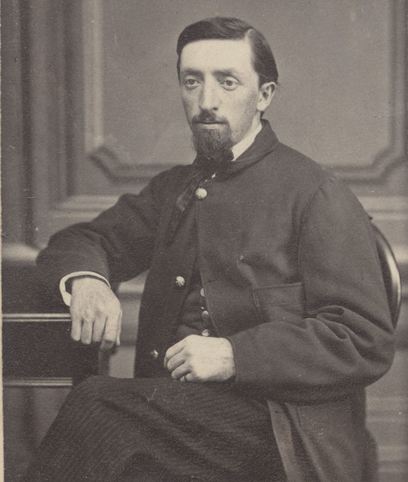
Portrait of H. E. Valentine from the Herbert E. Valentine Civil War Diary collection, Wake Forest University.
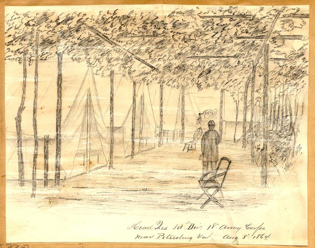
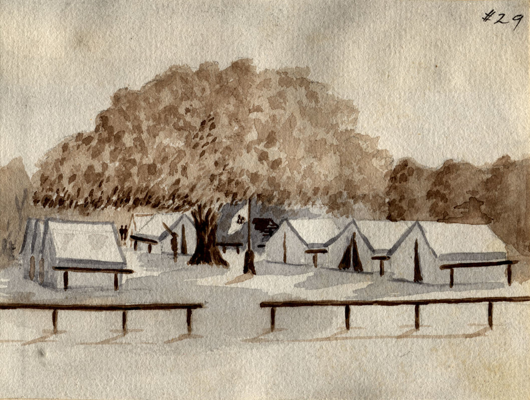
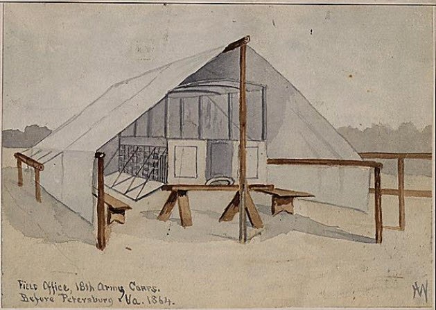
Herbert Eugene Valentine (1841-1917), a native of Salem, Massachusetts, served in the Union Army, 23rd Massachusetts Volunteers, Co. F. A photographer by trade, Valentine was responsible for making maps and sketches and taking photographs for official army use. Valentine's manuscript memoirs relate various anecdotes about his army experiences, mostly in Virginia, North Carolina, and South Carolina.
wakespace.lib.wfu.edu/handle/10339/50


​

​​
​


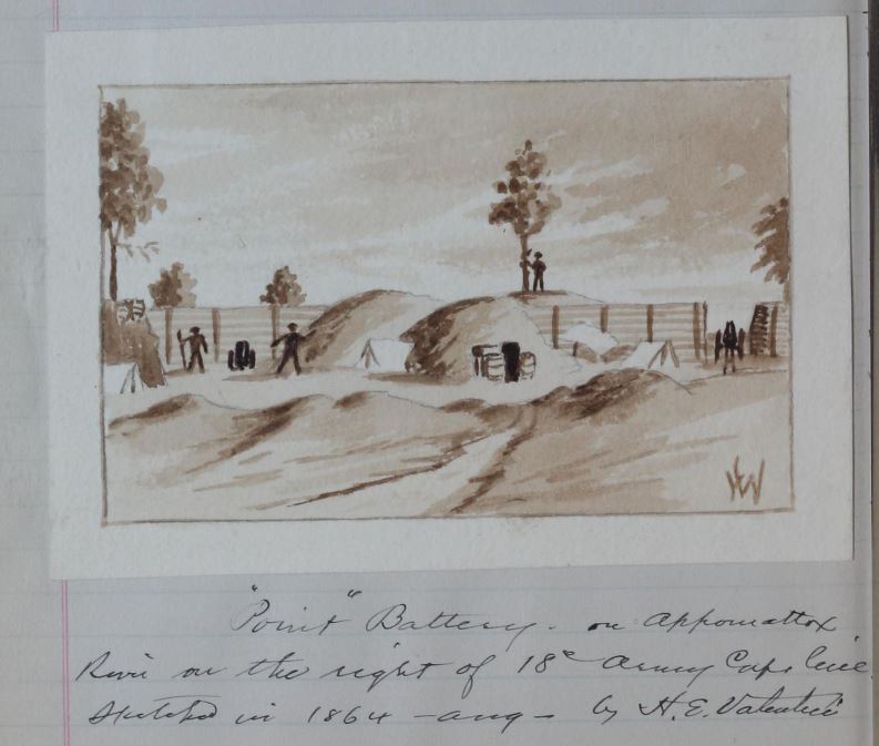
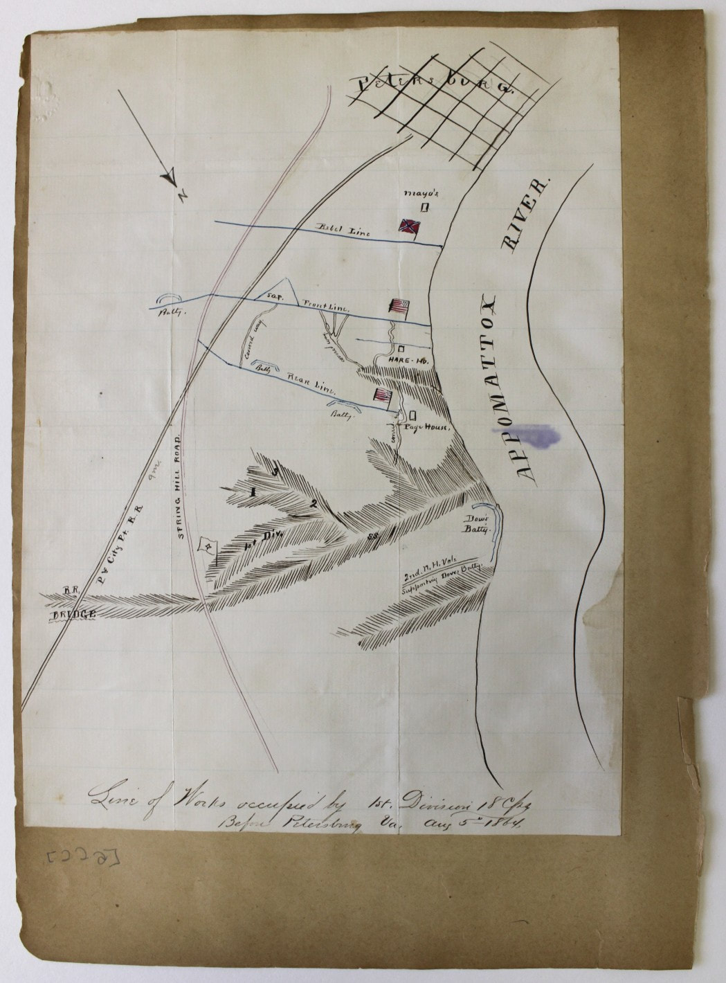
"An early morning Reconnaissance along the Appomattox River near Petersburg 1864."

At 3 A. M. July 11, I was awakened by Capt. M. B. Bessey A.A.I.G. on the staff of Brig. Genl. Geo. J. Stannard comd'g 1st Div. 18th A. C. Our Hd. Qr. were in a spur of the big Ravine that commenced at the River and circled to the left for several miles just within the Union Lines. Together we walked up the ravine to Capt. Long's quarters. Capt. Long was in command of the Division sharpshooters. After he joined us we took the road along the river for half a mile or more toward Point of Rocks; there crossing a wide field to the left, reached the woods lining the river bank. We kept along the bank toward the junction of the Appomattox and the James. It was still dark and we moved freely and safely, though involuntarily hastening our steps across the open spaces where we were exposed to any observers on the other side. We passed a 2 gun battery and occasionally a pit dug for the sharpshooters. As it began to grow light we came to a large tree just opposite the rebel fort, which marked the limits of the present trip. Here we crept about very cautiously, exposing ourselves as little as possible to the enemy's sharpshooters, the river being quite narrow at this point. As the dawn came on, we got a very good view of the rebel works, and I began a sketch-map of the river, batteries and camps &c and their position in relation to our own works, estimating distances as accurately as possible. As soon as it was broad daylight and the sketch completed we began our return trip, and here came the excitement. We had to move very carefully, keeping behind the bushes and trees which lined the river's bank, running very swiftly and singly [?] as we passed the open spaces. We made some observations through the loopholes in the rifle-pits, and could plainly see the rebel camps, and men moving about, and we heard the bugles sounding perhaps the "Reveille." At the 2 gun battery we stopped quite a while getting a good view of the works and making some additions to the map. The Sergeant in charge reminded me that my white paper made a good mark and suggested that I carry it under cover. Keeping on we soon came to the place where we struck the river on our way out, but instead of crossing to the road we kept along the river to the battery on the point. Here was quite a stretch of uncovered ground which we had to cross, and we skipped over it in lively style, our speed accelerated by the singing of the "minies" which at least proclaimed the good intentions of "our friend the enemy." Passing down into the ravine we regaled ourselves on the delicious blackberries which grew very abundantly at that point. Climbing the side of the ravine, we found ourselves in a covered way through which we passed into the battery. It was known as "Dow's battery," sometimes called the "Point battery" as the point upon which it was located was somewhat prominent just at the bend of the river. The battery mounted 2 30 pounder Parrott guns and several mortars. Standing directly behind, we could see the bomb leave the mortar and sail majestically into the air, the fuse hissing and sputtering as it went. A large telescope was mounted in one of the embrazures through which we looked directly into the city. Under the bridge connecting Petersburg and the opposite shore we saw a man in his shirt-sleeves carrying a bucket of water which he had just dipped from the river. A clock on one of the steeples indicated twenty minutes of six o'clock. We lingered here for quite a while but as we must get back to HdQtrs., and withal were somewhat hungry, we left. It was our intention to get into the 2nd line [?] and get (as we thought we could) a fine view down the river, but as we must go across the "open" to do it, or go a long way round to keep under cover, we gave it up. Walking for a little distance along the edge of the bluff, we descended into the ravine, and, once hidden by the trees made our way back to camp, arriving just in season for a bountiful breakfast of Hard Tack & coffee. ​
Picture
Picture
Picture
Picture
Picture
Picture
Picture
Picture
Picture
Picture
Proudly powered by Weebly
Picture