
Library of Congress, cw 0610000.
ca. July 13, 1864, MAP of confederate lines
HDQRS. ENGINEERS, DEPT. of N.C. AND SOUTHERN VA.
July 12, 1864
Maj. Gen. D. H. Hill,
Inspector General of Trenches:
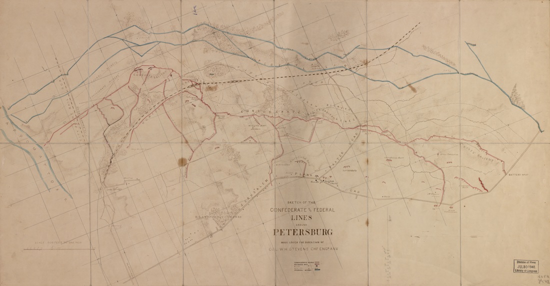
GENERAL: I have the honor to submit to you the following report of the work in progress and to be done on the lines. At Pegram’s battery, the right of Major-General Johnson’s lines, the work has nearly (so far as ordered) been completed; that to be done consists in finishing the second rear line, and running out listening galleries to the front of the works. The former of these works is now being done by General Gracie, and the latter by Capt. H. T. Douglas, engineer troops….On the line occupied by Major-General Hoke, Colquitt’s salient has, as the most critical point, received the most attention. At this point, as at Battery Pegram, rear lines are being constructed across both salient angles. Great difficulties have been encountered at this point during the progress of the work, owing to the constant firing of the enemy on the working parties, which accounts for the little progress made. A rear position for the guns in this salient has also been made, and was just ready when the order to remove the guns was countermanded by General Beauregard. Two galleries, six feet below the surface, for the purposes of listening to and counteracting any mining operations of the enemy, have been commenced at this point and are being carried out by Captain Douglas, of the engineer troops. The rest of General Hoke’s line, with the exception of the battery at City Point road and what little work is necessary to make it, conforms to general orders from department headquarters…. The battery at City Point [road] is now being arranged for an embrasure to cover the ground between Harris’ house and the salient. A compass survey is now being made of the whole line, a map of which will probably be ready tomorrow,
I am, general, very respectfully, your obedient servant,
W. H. STEVENS
Colonel and Acting Chief Engineer
OR, XL, Part III, 771
July 12, 1864
Maj. Gen. D. H. Hill,
Inspector General of Trenches:
GENERAL: I have the honor to submit to you the following report of the work in progress and to be done on the lines. At Pegram’s battery, the right of Major-General Johnson’s lines, the work has nearly (so far as ordered) been completed; that to be done consists in finishing the second rear line, and running out listening galleries to the front of the works. The former of these works is now being done by General Gracie, and the latter by Capt. H. T. Douglas, engineer troops….On the line occupied by Major-General Hoke, Colquitt’s salient has, as the most critical point, received the most attention. At this point, as at Battery Pegram, rear lines are being constructed across both salient angles. Great difficulties have been encountered at this point during the progress of the work, owing to the constant firing of the enemy on the working parties, which accounts for the little progress made. A rear position for the guns in this salient has also been made, and was just ready when the order to remove the guns was countermanded by General Beauregard. Two galleries, six feet below the surface, for the purposes of listening to and counteracting any mining operations of the enemy, have been commenced at this point and are being carried out by Captain Douglas, of the engineer troops. The rest of General Hoke’s line, with the exception of the battery at City Point road and what little work is necessary to make it, conforms to general orders from department headquarters…. The battery at City Point [road] is now being arranged for an embrasure to cover the ground between Harris’ house and the salient. A compass survey is now being made of the whole line, a map of which will probably be ready tomorrow,
I am, general, very respectfully, your obedient servant,
W. H. STEVENS
Colonel and Acting Chief Engineer
OR, XL, Part III, 771
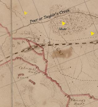
A detail of Gracie's Salient from the above map shows an interesting and often overlooked development. First, the Federals appear to have established a coehorn mortar battery (center highlight) on the far (west) bank of Poor or Taylor's Creek. The aggressive Federal presence on this bank is further shown by a picket line (highlighted dashed line) that is pushed right up against Gracie's Salient and then continued south along the railroad. Federal proximity is also confirmed by the Confederate counter-mines that were built in front of Gracie's later in July. When did the Federals occupy this ground? From what we can discern from the documentary record, it must have been sometime on June 18th when Federal attacks swept over the southern flank of Hare House Hill.
Behind the main Confederate line, the location of the 8-inch Columbiad can be found today. Although in rather poor condition, the configuration of the emplacement is unmistakable. Sketched in lines of fire, shows the great pains Confederate artillerists took to generate oblique and enfilade fires across the front of their position.
