The Petersburg Project
  • Home
    • About Us
  • Blog and Updates
  • The Crater
  • Petersburg in Pencil and Ink
    • Alfred R. Waud, Special Artist at Petersburg >
      • In Front of Petersburg
      • Waud Drawing of 5th Corps Fortifications
      • Rives Salient ("Fort Mahone")
      • Soldiers' Wells
      • The Mine Explosion
    • William Waud, Special Artist
    • Charles H. Chapin, Special Artist
    • Edwin Forbes, Special Artist at Petersburg
    • Joseph Becker, Special Artist at Petersburg
    • Edward Mullen, Special Artist at Petersburg
    • Andrew W. Warren, Special Artist
    • Winslow Homer, Special Artist
    • Enlisted Artists >
      • Charles Wellington Reed
      • Andrew McCallum
      • Francis Knowles
      • James William Pattison
      • Herbert Valentine
  • Petersburg Photographs --So Many!
    • Working with Photographs
    • Steeples of Petersburg
    • Petersburg Panorama 1865
    • City Point
    • City Point Wharf Explosion, Aug. 9, 1864
    • Fort Rice?? We don't think so!
    • Federal Picket Line, Jerusalem Plank Road
    • Timothy O'Sullivan, Photographer at Petersburg >
      • O'Sullivan and Vest Man
      • Fort Morton and Baxter Road Group
      • Fort Haskell Panorama
      • Fort Stedman Group
      • Gracie's Salient Group
      • Bombproofs behind Fort Haskell
      • Camp of the 50th N. Y. Engineers
    • John Reekie, Photographer for the Quartermaster Corps
    • Thomas C. Roche, Photographer at Petersburg
    • David Knox, Photographer at Petersburg
    • Andrew J. Russell, Photographer at Petersburg >
      • "Fort Mahone" CS Batteries 25 & 27
  • U. S. Military Railroad
    • Terminus of Military R. R. at City Point
    • City Point to Clark's Station
    • Pitkin's Station to Shooting Hill
    • Hancock's Junction/Jerusalem Plank Road
    • Parke's Station
    • Warren's Station
    • Patrick's Station
  • Maps and Topogs
    • Grand Medicine Pow-wow
    • Michler's Reports from Topographical Department
    • John E. Weyss, Cartographer
    • William H. Paine, Cartographer
    • Gilbert Thompson
  • Confederate Maps
    • Confederate Defenses 1862
    • Gilmer-Campbell Maps, 1864
    • Stevens Map July 1864
    • Fields of Fire
    • Coit's map of the Crater Battlefield
  • Federal Maps
    • June 18, 1864-Federal Engineers Map
    • June 21, 1864, Federal Engineers Map
    • June 22, 1864. Second Corps at Jerusalem Plank Road
    • June 30, 1864 -- XVIII Corps Map
    • Undated Federal Engineers Map--June-July, 1864
    • July 1864 Map of XVIII Corps Lines
    • 18th Corps, June 18, 1864
    • Native American Perspective of the Crater
    • August 28, 1864, Michler Map
    • IX Corps, Peebles and Pegrams Farms Oct. 1864
    • Army of the Potomac, Nov. 2, 1864
    • 1864, Coast Survey Map of Petersburg
    • Army of the Potomac, Routes of the Corps to Petersburg
    • Manuscript Survey, 1865
    • Michler-Weyss, Siege of Petersburg
    • Michler Map Series 1865-1867
    • 1871, Map of Recapture of Ft. Stedman
    • 1881, Boydton Plank Road
  • Confederate Forts and Batteries
    • Dimmock Line >
      • Priest Cap
      • French Rifle Pits
    • Fort Clifton
    • Confederate Leadworks
  • Federal Forts and Batteries
    • Battery X
    • Fort Alexander Hayes
    • Fort Avery
    • Fort Conahey
    • Fort Davis & Battery XXII
    • Fort Fisher
    • Fort Meikel --Photographic Views
    • Fort Morton
    • Fort Patrick Kelly
    • Fort Sedgwick, better known as Fort Hell,
    • Fort Wadsworth -- the Evolution
    • Fort Willcox or Battery XVI
    • Hare House Hill
  • Battlefield Features
    • Aiken House
    • Avery House
    • Bailey/Johnston Farm
    • Blandford Church
    • Broadway Landing, Appomattox River
    • The Crater
    • Cummings House
    • Dams and Inundations
    • Dunn House
    • Friend House >
      • View from Friend House toward Gibben complex and Petersburg
    • Globe Tavern / Weldon Railroad
    • Gregory House
    • Griffith Farm
    • Gurley House
    • Hare House
    • The "Horseshoe"
    • Jones House
    • Jordan House
    • Pegram's Farm
    • Peebles Farm, Pegrams Farm, Poplar Springs Church
    • Shand House
    • Taylor Farm >
      • The Ice House
      • Surviving Taylor Barn
    • U. S. Engineers at the Williams House
    • Williams House
  • Signal Towers and Trees
    • Some Operations of the Signal Corps at Petersburg
  • Archeology
    • Geology of the Crater
    • Fieldwork -- Petersburg
    • Civil War Sinks
    • Deserted Confederate Camp
    • Gracie's Countermine
    • LIDAR Forts and Batteries
  • Articles, Papers, Presentations
    • Shiman: A Note on Maps
    • The Siege Landscape: Through Fire and Ice at Petersburg
    • "The Rebel in the Road"
    • "A Strange Sort of Warfare Underground"
    • Lost Trenches of Petersburg: June 17
    • Between the Lines
    • Combat Trenching: An Introduction
  • Encyclopedia
    • Glossary
    • The Battlefields
    • Siege Warfare
    • Union Lines
    • Confederate Lines
    • Combat >
      • June 30, 1864, Attack
      • Combat Entrenching
      • Trench Warfare in Civil War History
      • Chamberlain at Petersburg, June 18, 1864
  • Kittens, Puppies & Ponies
  • Executions!
  • Civil War Combat Trenching
  • Pontoon Bridges
  • Depot Hospital at City Point
  • New: Shot tower

Fort Morton

Fort Morton evolved into an enclosed fort from a 14-gun battery built on the Taylor Farm opposite Confederate Elliott's Salient. From here, on July 30, 1864, Maj. Gen. Ambrose Burnside and his staff observed the explosion of the Mine beneath Pegram's Battery and the failure of the subsequent attack.
Picture
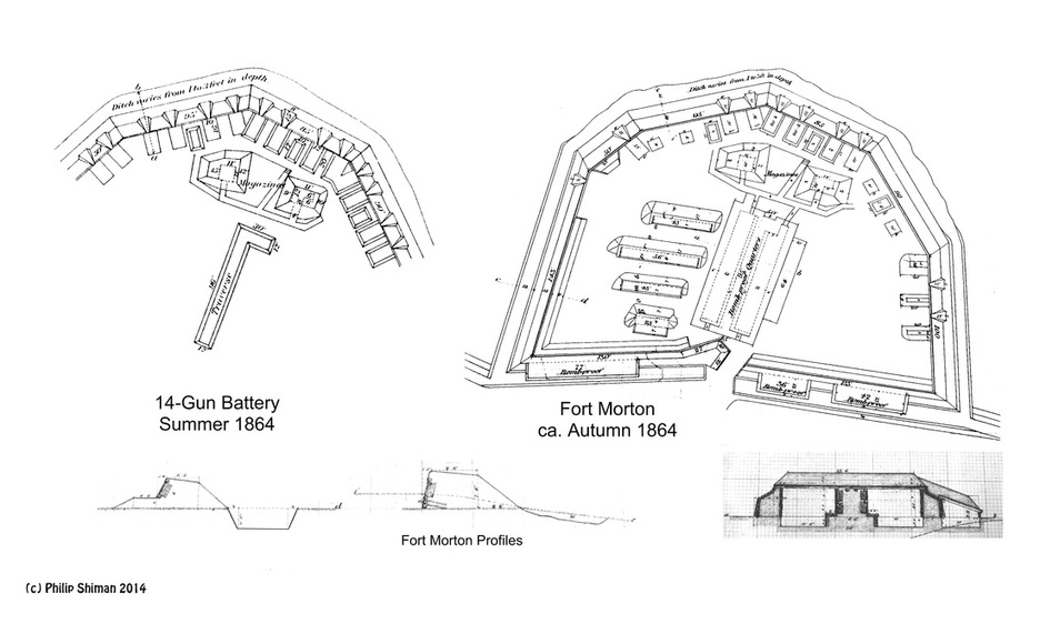
Mash-up of "Field Battery" (Military Atlas Plate 107:3) and Engineers Plan of Fort Morton (RG77 Dr. 150-18) by Philip Shiman.
Picture
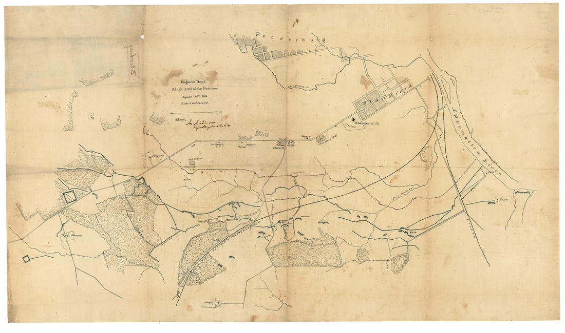
Map of Siege Lines, August 28, 1864, Engineer Dept. HdQrs Army of the Potomac. LC http://hdl.loc.gov/loc.ndlpcoop/glva01.lva00194
Picture
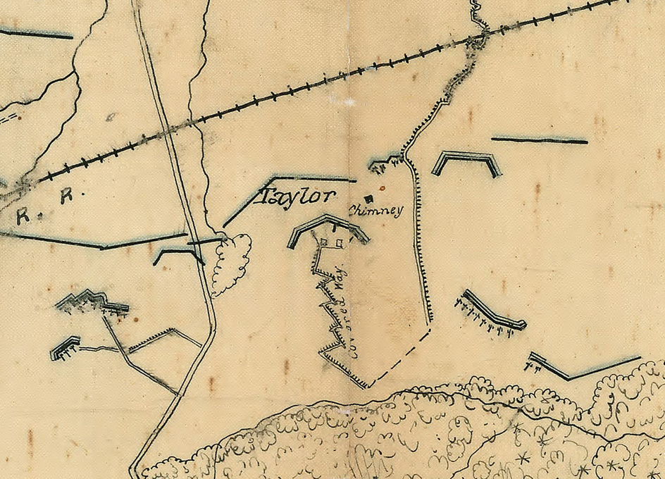
Detail from the above map showing the 14-Gun Battery at the Taylor House, which was afterwards redesigned as Fort Morton.
Picture
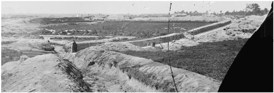
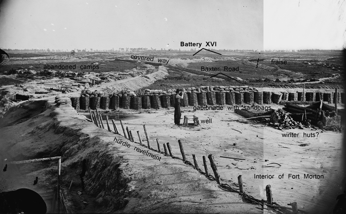
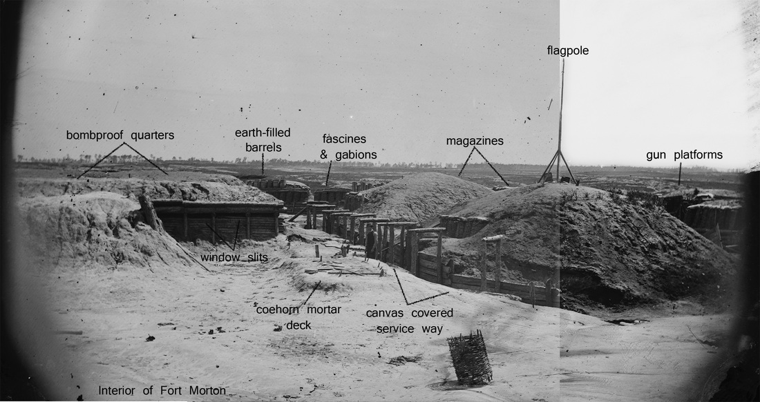
An expansive view into Fort Morton from near Battery XVI (LC-B811- 1070), unattributed photograph by Timothy O'Sullivan. Baxter Road can be seen crossing the center of this image. An opening was made in the substantial parapet to allow Federals to pursue the evacuating Confederate army.
Picture
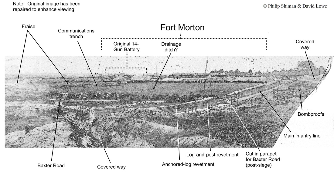
This schematic by Phil Shiman points out various features in the photograph. Download the original and enjoy the close-up details of this especially clear image. (http://www.loc.gov/pictures/item/cwp2003004577/PP/ )
Picture
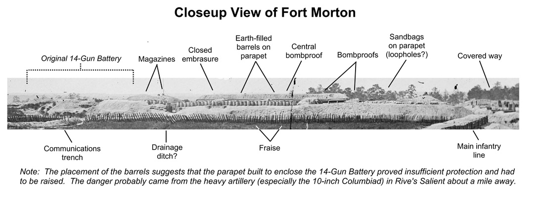
This detail demonstrates the substantial changes made to the Federal siegeworks in the fall of 1864. The open 14-gun battery on the left was conceived merely as a gun platform to concentrate and deliver artillery fire. Enclosed for all around defense, Fort Morton occupied and dominated the ground. As far as the Confederates were concerned, Morton was invincible. Federal engineering at its finest.
Picture
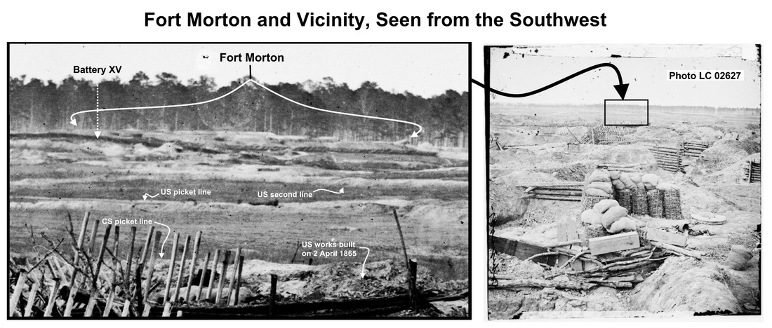
View of Fort Morton from Confederate Battery 25 (LC-B811- 3219).
Picture
This unattributed stereograph (LC-B815- 1054) is captioned "Petersburg, Virginia. Earthworks in front of Petersburg." It was taken by Timothy O'Sullivan from the northern wall of Fort Morton, looking south by west.
Picture
Picture
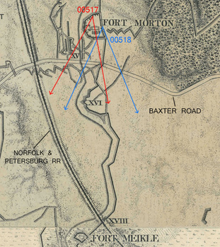
O'Sullivan and his assistant made at least two exposures of the interior of Fort Morton -- LC-B815- 1054 (00517 above) and LC-B815- 1055 (00518 below) as shown on the detail here. Three images were taken at Battery XV looking south and one near Battery XVI looking north. These constitute the Baxter Road series. The photographers' wagon was largely limited to passable roads. The camera positions needed to be within a close distance of the wagon.

Picture
Detail from LC-B815- 1055 (00518), showing a supply wagon, likely part of the photographers party, parked in Baxter Road.
Picture
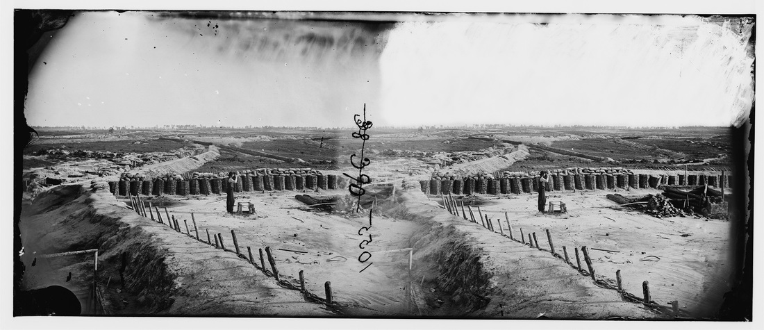
This unattributed stereograph (LC-B815- 1055) captioned "Petersburg, Virginia. Earthworks in front of Petersburg" was taken by O'Sullivan's assistant from the rear wall of Fort Morton at the sally port. O'Sullivan is drinking from a tin cup at the well.
Picture
Picture
Proudly powered by Weebly
Picture