The Petersburg Project
  • Home
    • About Us
  • Blog and Updates
  • Petersburg Panorama 1865
  • Petersburg in Pencil and Ink
    • Alfred R. Waud, Special Artist at Petersburg >
      • In Front of Petersburg
      • Waud Drawing of 5th Corps Fortifications
      • Rives Salient ("Fort Mahone")
      • Soldiers' Wells
      • The Mine Explosion
    • William Waud, Special Artist
    • Charles H. Chapin, Special Artist
    • Edwin Forbes, Special Artist at Petersburg
    • Joseph Becker, Special Artist at Petersburg
    • Edward Mullen, Special Artist at Petersburg
    • Andrew W. Warren, Special Artist
    • Winslow Homer, Special Artist
    • Enlisted Artists >
      • Charles Wellington Reed
      • Andrew McCallum
      • Francis Knowles
      • James William Pattison
      • Herbert Valentine
  • Hare House Hill
  • Petersburg Photographs
    • Steeples of Petersburg
    • City Point
    • City Point Wharf Explosion, Aug. 9, 1864
    • Fort Rice?? We don't think so!
    • Working with Photographs
    • Federal Picket Line, Jerusalem Plank Road
    • Timothy O'Sullivan, Photographer at Petersburg >
      • O'Sullivan and Vest Man
      • Fort Morton and Baxter Road Group
      • Fort Haskell Panorama
      • Fort Stedman Group
      • Gracie's Salient Group
      • Bombproofs behind Fort Haskell
      • Camp of the 50th N. Y. Engineers
    • John Reekie, Photographer for the Quartermaster Corps
    • Thomas C. Roche, Photographer at Petersburg
    • David Knox, Photographer at Petersburg
    • Andrew J. Russell, Photographer at Petersburg >
      • "Fort Mahone" CS Batteries 25 & 27
  • U. S. Military Railroad
    • Terminus of Military R. R. at City Point
    • City Point to Clark's Station
    • Pitkin's Station to Shooting Hill
    • Shooting Hill
    • Hancock's Junction/Jerusalem Plank Road
    • Parke's Station
    • Warren's Station
    • Patrick's Station
  • Maps and Topogs
    • Grand Medicine Pow-wow
    • Michler's Reports from Topographical Department
    • John E. Weyss, Cartographer
    • William H. Paine, Cartographer
    • Gilbert Thompson
    • Confederate Maps >
      • Confederate Defenses 1862
      • Gilmer-Campbell Maps, 1864
      • Stevens Map July 1864
      • Fields of Fire
      • Coit's map of the Crater Battlefield
    • Union Maps >
      • June 18, 1864-Federal Engineers Map
      • June 21, 1864, Federal Engineers Map
      • June 22, 1864. Second Corps at Jerusalem Plank Road
      • June 30, 1864 -- XVIII Corps Map
      • Undated Federal Engineers Map--June-July, 1864
      • July 1864 Map of XVIII Corps Lines
      • 18th Corps, June 18, 1864
      • Native American Perspective of the Crater
      • August 28, 1864, Michler Map
      • IX Corps, Peebles and Pegrams Farms Oct. 1864
      • Army of the Potomac, Nov. 2, 1864
      • 1864, Coast Survey Map of Petersburg
      • Manuscript Survey, 1865
      • Michler-Weyss, Siege of Petersburg
      • Michler Map Series 1865-1867
      • 1871, Map of Recapture of Ft. Stedman
  • Battlefield Features
    • Aiken House
    • Avery House
    • Battery X
    • Blandford Church
    • Broadway Landing, Appomattox River
    • The Crater
    • Cummings House
    • Dams and Inundations
    • Dimmock Line >
      • Priest Cap
      • French Rifle Pits
    • Dunn House
    • Fort Alexander Hayes
    • Fort Avery
    • Fort Davis & Battery XXII
    • Fort Fisher
    • Fort Meikel --Photographic Views
    • Fort Morton
    • Fort Patrick Kelly
    • Fort Sedgwick, better known as Fort Hell,
    • Fort Wadsworth -- the Evolution
    • Fort Willcox or Battery XVI
    • Friend House
    • Globe Tavern / Weldon Railroad
    • Gregory House
    • Griffith Farm
    • Gurley House
    • Hare House
    • Jones House
    • Jordan House
    • Confederate Leadworks
    • Pegram's Farm
    • Peebles Farm, Pegrams Farm, Poplar Springs Church
    • Shand House
    • Taylor Farm >
      • The Ice House
      • Surviving Taylor Barn
    • U. S. Engineers at the Williams House
    • Williams House
  • Signal Towers and Trees
    • Some Operations of the Signal Corps at Petersburg
  • Archeology
    • Geology of the Crater
    • Fieldwork -- Petersburg
    • Civil War Sinks
    • Deserted Confederate Camp
    • Gracie's Countermine
    • LIDAR Forts and Batteries
  • Articles, Papers, Presentations
    • Shiman: A Note on Maps
    • The Siege Landscape: Through Fire and Ice at Petersburg
    • "The Rebel in the Road"
    • "A Strange Sort of Warfare Underground"
    • Lost Trenches of Petersburg: June 17
  • Encyclopedia
    • Glossary
    • The Battlefields
    • Siege Warfare
    • Union Lines
    • Confederate Lines
    • Combat >
      • June 30, 1864, Attack
      • Combat Entrenching
      • Trench Warfare in Civil War History
      • Chamberlain at Petersburg, June 18, 1864
  • Kittens, Puppies & Ponies
  • The "Horseshoe"
  • Executions!
  • Combat Trenching: An Introduction
  • New: Between the Lines
  • Progressive Entrenching
  • View from Friend House toward Gibben complex and Petersburg
  • Fort Conahey
  • New Page

Hancock's Junction / Jerusalem Plank Road  U. S. M. R. R. Mile 11

From Jerusalem Plank Road near the Jones House. From here, the main branch of the USMRR continued west to join the Weldon Railroad near Globe Tavern and what would become Fort Wadsworth. A southern branch running parallel with the plank road connected at 1 mile to Gregg Station and 2 1/4 miles to Crawford Station at the Temple House.
Picture
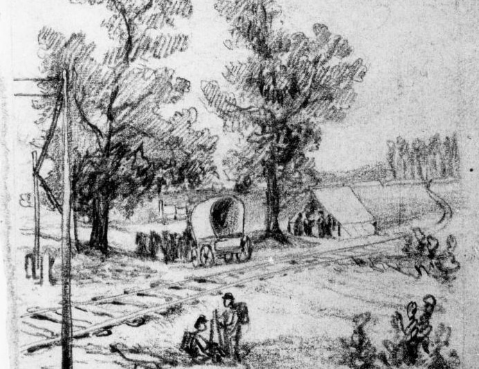
Becker Collection 32645 detail. "Scenes from the Construction of Grant's Railroad. Crossing Jerusalem Plank Road." Andrew McCallum, artist.
Picture
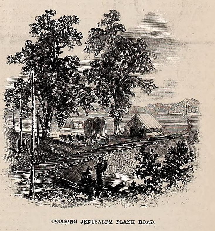
Woodcut in Frank Leslie's Illustrated, Oct. 1, 1864.
Picture
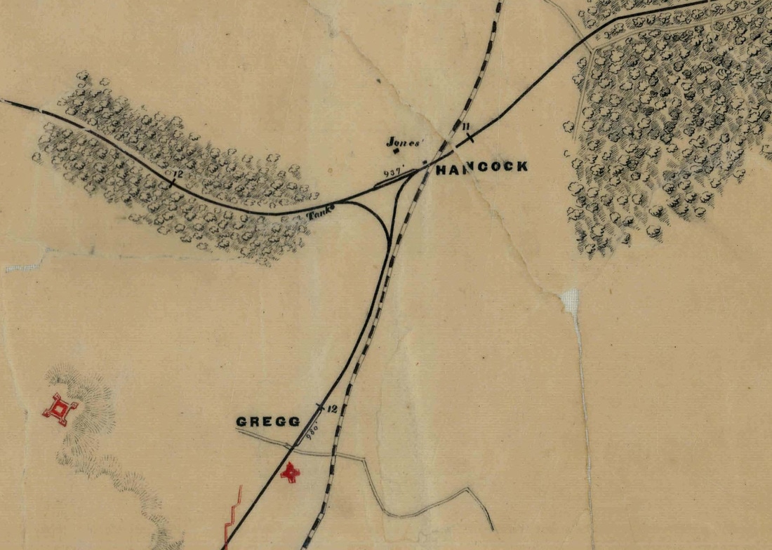
Vicinity of Hancock's Junction at the crossing of Jerusalem Plank Road from NARA "Map of the City Point & Army Line." Courtesy of NARA and of Ted Linton, who procured such a detailed scan.
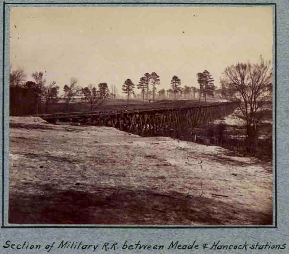
Picture
Proudly powered by Weebly
Picture