The Petersburg Project
  • Home
    • About Us
  • Blog and Updates
  • Petersburg Panorama 1865
  • Steeples of Petersburg
  • The Mine Explosion and its Crater
  • Petersburg in Pencil and Ink
    • Alfred R. Waud, Special Artist at Petersburg >
      • Waud Drawing of 5th Corps Fortifications
    • William Waud, Special Artist
    • Charles H. Chapin, Special Artist
    • Joseph Becker, Special Artist at Petersburg
    • Edwin Forbes, Special Artist at Petersburg
    • Winslow Homer, Special Artist
    • Edward Mullen, Special Artist at Petersburg
    • Andrew W. Warren, Special Artist
    • Enlisted Artists >
      • Charles Wellington Reed
      • Andrew McCallum
      • Francis Knowles
      • James William Pattison
      • Herbert Valentine
      • Howard A. Camp
  • Petersburg Photographs --So Many!
    • Working with Photographs
    • City Point
    • City Point Wharf Explosion, Aug. 9, 1864
    • Fort Rice?? We don't think so!
    • Federal Picket Line, Jerusalem Plank Road
    • Egbert Guy Fowx, Photographer at Petersburg
    • Timothy O'Sullivan, Photographer at Petersburg >
      • Fort Morton and Baxter Road Group
      • Fort Haskell Panorama
      • Fort Stedman Group
      • Gracie's Salient Group
      • Bombproofs behind Fort Haskell
      • Camp of the 50th N. Y. Engineers
    • David Knox, Photographer at Petersburg
    • William Redish Powell, Photographer at Petersburg
    • John Reekie, Photographer at Petersburg
    • Thomas C. Roche, Photographer at Petersburg
    • Andrew J. Russell, Photographer at Petersburg >
      • "Fort Mahone" CS Batteries 25 & 27
  • U. S. Military Railroad
    • Terminus of Military R. R. at City Point
    • City Point to Clark's Station
    • Pitkin's Station to Shooting Hill
    • Hancock's Junction/Jerusalem Plank Road
    • Parke's Station
    • Warren's Station
    • Patrick's Station
  • Maps and Topogs
    • Grand Medicine Pow-wow
    • Michler's Reports from Topographical Department
    • John E. Weyss, Cartographer
    • William H. Paine, Cartographer
    • Gilbert Thompson
  • Confederate Maps
    • Confederate Defenses 1862
    • Gilmer-Campbell Maps, 1864
    • Stevens Map July 1864
    • Fields of Fire
    • Coit's map of the Crater Battlefield
  • Federal Maps
    • Army of the Potomac, Routes of the Corps to Petersburg
    • June 18, 1864-Federal Engineers Map
    • June 18, 1864, 18th Corps
    • June 21, 1864, Federal Engineers Map
    • June 22, 1864. Second Corps at Jerusalem Plank Road
    • June 29, 1864. Bermuda Hundred
    • June 30, 1864 -- XVIII Corps Map
    • June-July, Undated Federal Engineers Map-
    • July 1864 Map of XVIII Corps Lines
    • Crater, Native American Perspective of the Crater
    • August 28, 1864, Michler Map
    • September 13, 1864, Recon Map
    • September 30, 1864, Warren Map
    • October 1864, Two IX Corps Maps
    • Nov. 2, 1864, Army of the Potomac
    • 1864, Coast Survey Map of Petersburg
    • NEW 1865-1867, Manuscript Survey Maps
    • 1864-1867, Michler-Weyss, Siege of Petersburg
    • 1865-1867, Michler Map Series
    • 1871, Map of Recapture of Ft. Stedman
    • 1881, Boydton Plank Road
  • Confederate Forts and Batteries
    • Dimmock Line >
      • Priest Cap
      • French Rifle Pits
    • Fort Clifton
    • "Fort Mahone" CS Batteries 25 & 27
    • Confederate 8-inch Columbiad
    • Leadworks
  • Federal Forts and Batteries
    • Battery X
    • Fort Alexander Hayes
    • Fort Avery
    • Fort Conahey
    • Fort Davis & Battery XXII
    • Fort Fisher
    • Fort Meikel --Photographic Views
    • Fort Morton
    • Fort Patrick Kelly
    • Fort Sedgwick, better known as Fort Hell,
    • Fort Wadsworth -- the Evolution
    • Fort Willcox or Battery XVI
  • Battlefield Features
    • Aiken House
    • Armstrong's Mill
    • Avery House
    • Bailey/Johnston Farm
    • Blandford Church
    • Broadway Landing, Appomattox River
    • The Crater
    • Cummings House
    • Dams and Inundations
    • WW Davis Farm
    • Dunn House
    • Friend House >
      • View from Friend House toward Gibben complex and Petersburg
    • Gibbons Properties
    • Globe Tavern / Weldon Railroad
    • Gregory House
    • Griffith Farm
    • Gurley House
    • Hare House
    • Hare House Hill
    • The "Horseshoe"
    • Jerusalem Plank Road
    • Jones House
    • Jordan House
    • Newmarket Racecourse
    • Pegram's Farm
    • Peebles Farm, Pegrams Farm, Poplar Springs Church
    • Shands House
    • Taylor Farm >
      • The Ice House
      • Surviving Taylor Barn
    • Williams House
  • Signal Towers and Trees
    • Some Operations of the Signal Corps at Petersburg
  • Archeology
    • Geology of the Crater
    • Fieldwork -- Petersburg
    • Civil War Sinks
    • Deserted Confederate Camp
    • Gracie's Countermine
    • LIDAR Forts and Batteries
  • Articles, Papers, Presentations
    • Shiman: A Note on Maps
    • The Siege Landscape: Through Fire and Ice at Petersburg
    • "The Rebel in the Road"
    • "A Strange Sort of Warfare Underground"
    • Lost Trenches of Petersburg: June 17
    • Between the Lines
    • Combat Trenching: An Introduction
    • Lowe -- Post-War Topographical Survey
    • Civil War Maps and Landscapes -- Observations
  • Kittens, Puppies & Ponies
  • Executions!
  • Notes on Leveled Earthworks
  • Civil War Combat Trenching
  • Depot Hospital at City Point
  • Dimmock Battery 5 Photographs
  • Pontoon Bridges
  • The Great Pontoon Bridge Across James River
  • Appomattox Mill Photographs
  • Campbell Dinwiddie County 1864

Is this Fort Rice? Is this a Confederate fortification? We don't think so.
Fort Hell (Sedgwick)


Picture
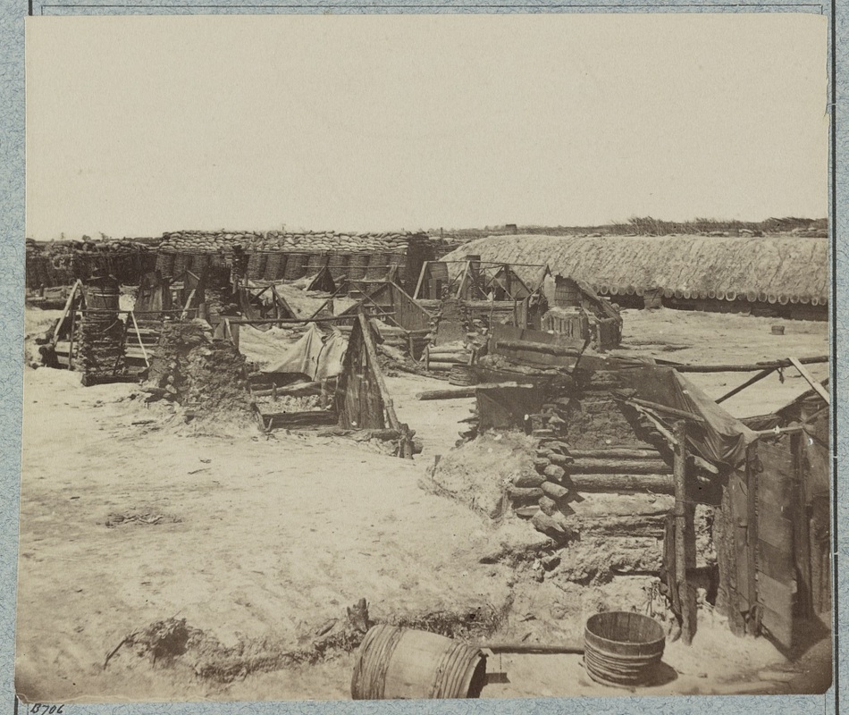
LC 32411. Although captioned "Fort Rice," this image was taken inside Fort Sedgwick. Points of comparison are presented on this page. This image shows a traverse built up of gabions and sandbags, and a piled earth over logs bombproof.
Picture
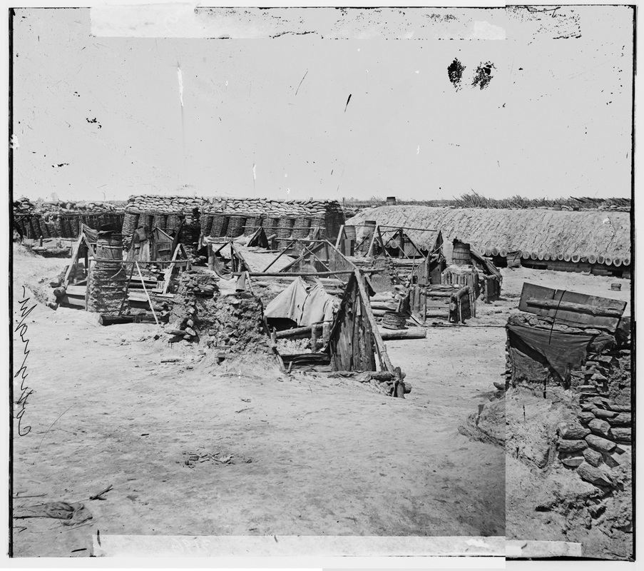
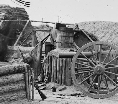
LC 02577-02578 "Soldiers' quarters in the Union Fort Rice adjoining Fort Sedgwick (Fort Hell)." The camera position was shifted a few yards closer from the previous view in this stereoscopic view.
Picture
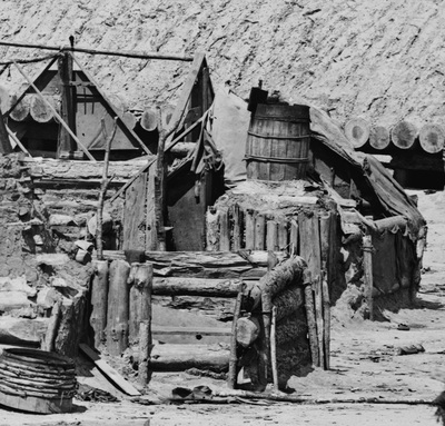
LC 02578 detail. Closer view of gabion and sandbag traverse and earth piled over logs bombproof.
Picture
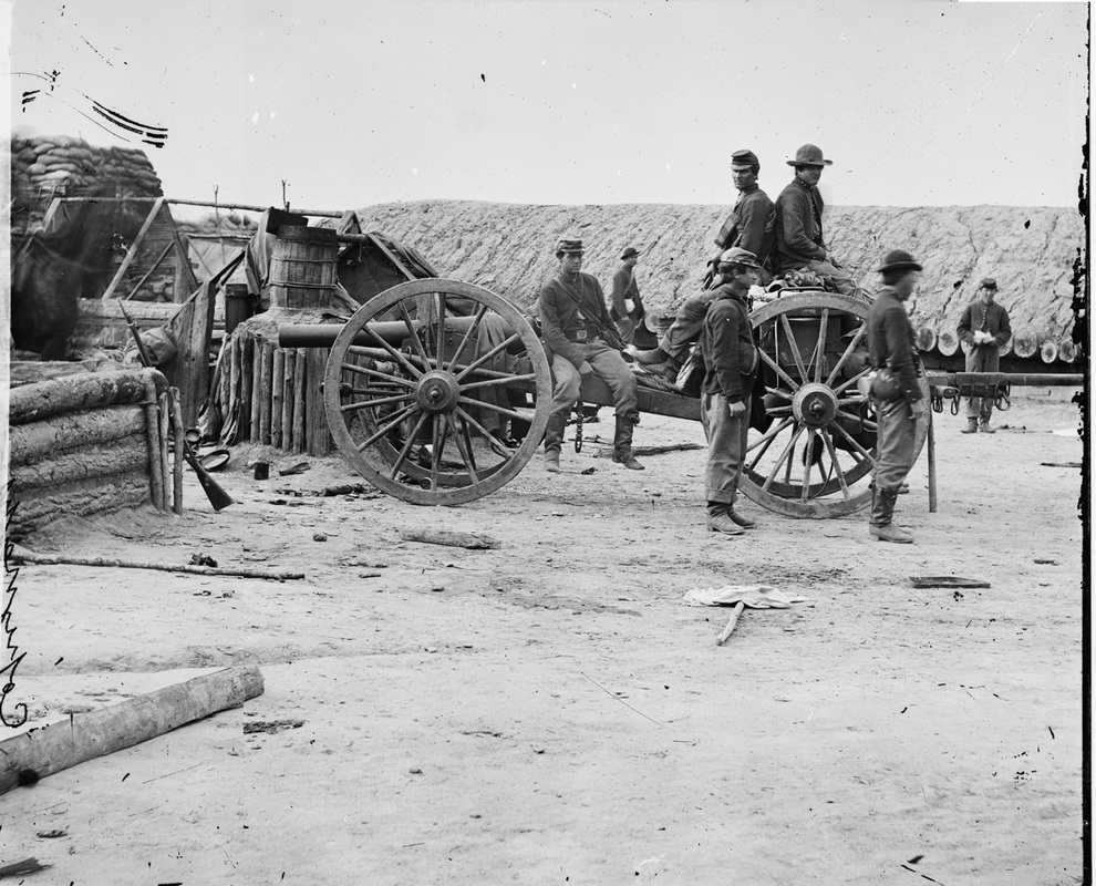
LC 02595-02596 "Petersburg, Va. Federal soldiers removing artillery from Confederate fortifications." This stereoscopic image was taken in front of the "piled earth over logs" bombproof in the above photo. The cannon and limber are posed in front of the rightmost cabin in the above photo.
Picture
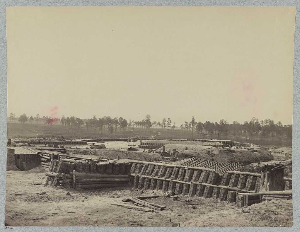
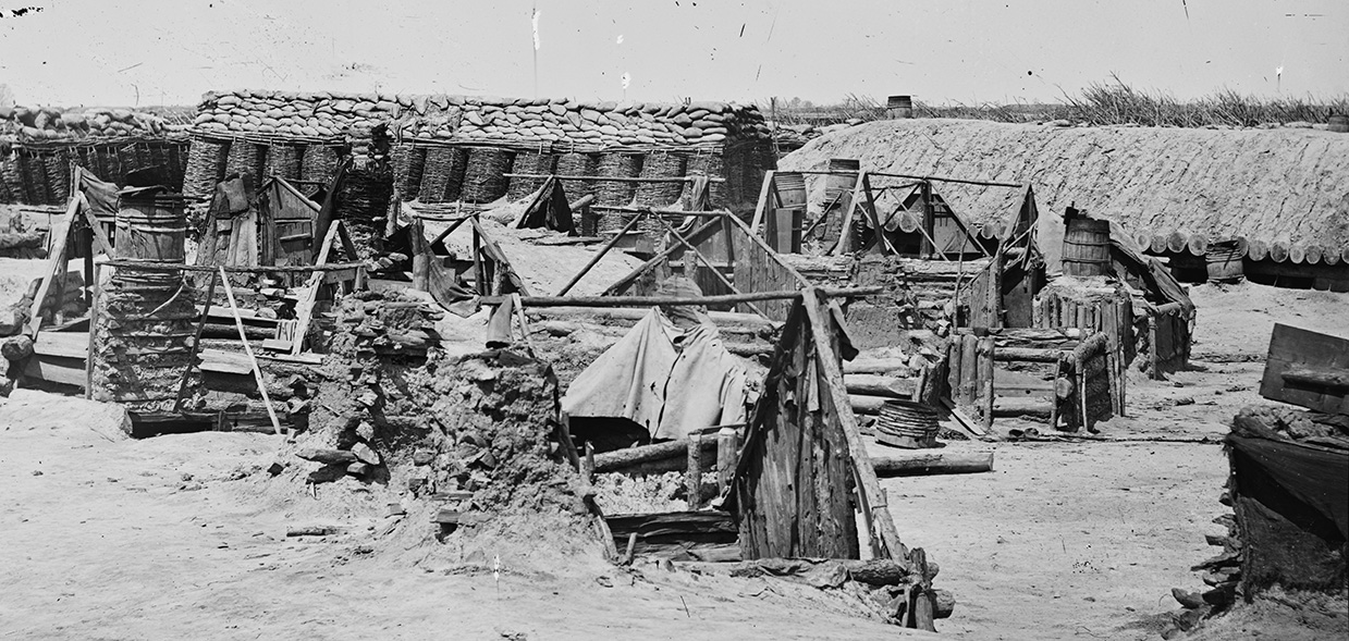
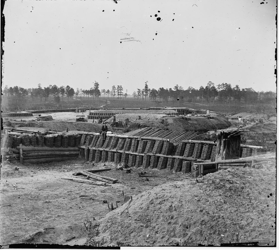
LC 32423. "Interior of Fort Sedgewick (i.e. Sedgwick)." Unattributed large format photograph. Two of the large bombproofs to the rear of the fort are those pictured in the "Fort Rice" photos.
Picture
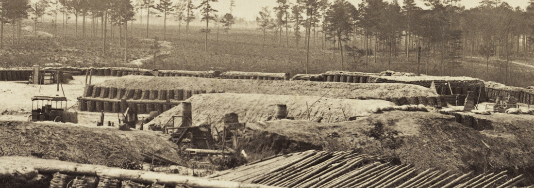
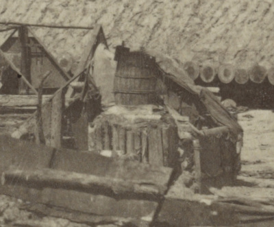
LC 32423 detail. Closer view of bombproof inside Fort Sedgewick, misidentified as "Confederate" or Fort Rice. Note the photographers' wagon on the left. Note the cluster of roofless cabins in front of the "piled earth over logs" bombproof.
Picture
LC 02840-02841 "Petersburg, Virginia. Interior view of Fort Sedgwick," unattributed stereoscope. This image was taken at the same time as 32423 above. The photographer's wagon has not moved.
Picture
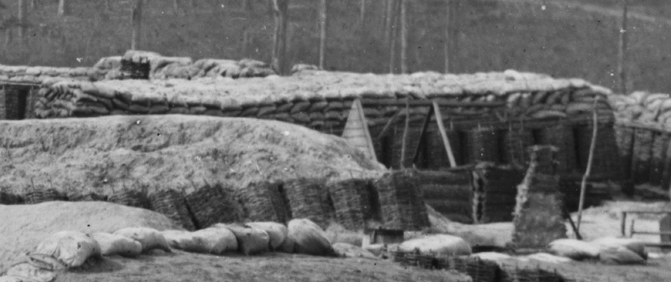
LC 02840 detail. Gabion and sandbag traverse that appears in the images of "Fort Rice." Numerous points of correspondence.
Proudly powered by Weebly
Picture