The Petersburg Project
  • Home
    • About Us
  • Blog and Updates
  • Petersburg Panorama 1865
  • Steeples of Petersburg
  • The Mine Explosion and its Crater
  • Petersburg in Pencil and Ink
    • Alfred R. Waud, Special Artist at Petersburg >
      • Waud Drawing of 5th Corps Fortifications
    • William Waud, Special Artist
    • Charles H. Chapin, Special Artist
    • Joseph Becker, Special Artist at Petersburg
    • Edwin Forbes, Special Artist at Petersburg
    • Winslow Homer, Special Artist
    • Edward Mullen, Special Artist at Petersburg
    • Andrew W. Warren, Special Artist
    • Enlisted Artists >
      • Charles Wellington Reed
      • Andrew McCallum
      • Francis Knowles
      • James William Pattison
      • Herbert Valentine
      • Howard A. Camp
  • Petersburg Photographs --So Many!
    • Working with Photographs
    • City Point
    • City Point Wharf Explosion, Aug. 9, 1864
    • Fort Rice?? We don't think so!
    • Federal Picket Line, Jerusalem Plank Road
    • Egbert Guy Fowx, Photographer at Petersburg
    • Timothy O'Sullivan, Photographer at Petersburg >
      • Fort Morton and Baxter Road Group
      • Fort Haskell Panorama
      • Fort Stedman Group
      • Gracie's Salient Group
      • Bombproofs behind Fort Haskell
      • Camp of the 50th N. Y. Engineers
    • David Knox, Photographer at Petersburg
    • William Redish Powell, Photographer at Petersburg
    • John Reekie, Photographer at Petersburg
    • Thomas C. Roche, Photographer at Petersburg
    • Andrew J. Russell, Photographer at Petersburg >
      • "Fort Mahone" CS Batteries 25 & 27
  • U. S. Military Railroad
    • Terminus of Military R. R. at City Point
    • City Point to Clark's Station
    • Pitkin's Station to Shooting Hill
    • Hancock's Junction/Jerusalem Plank Road
    • Parke's Station
    • Warren's Station
    • Patrick's Station
  • Maps and Topogs
    • Grand Medicine Pow-wow
    • Michler's Reports from Topographical Department
    • John E. Weyss, Cartographer
    • William H. Paine, Cartographer
    • Gilbert Thompson
  • Confederate Maps
    • Confederate Defenses 1862
    • Gilmer-Campbell Maps, 1864
    • Stevens Map July 1864
    • Fields of Fire
    • Coit's map of the Crater Battlefield
  • Federal Maps
    • Army of the Potomac, Routes of the Corps to Petersburg
    • June 18, 1864-Federal Engineers Map
    • June 18, 1864, 18th Corps
    • June 21, 1864, Federal Engineers Map
    • June 22, 1864. Second Corps at Jerusalem Plank Road
    • June 29, 1864. Bermuda Hundred
    • June 30, 1864 -- XVIII Corps Map
    • June-July, Undated Federal Engineers Map-
    • July 1864 Map of XVIII Corps Lines
    • Crater, Native American Perspective of the Crater
    • August 28, 1864, Michler Map
    • September 13, 1864, Recon Map
    • September 30, 1864, Warren Map
    • October 1864, Two IX Corps Maps
    • Nov. 2, 1864, Army of the Potomac
    • 1864, Coast Survey Map of Petersburg
    • NEW 1865-1867, Manuscript Survey Maps
    • 1864-1867, Michler-Weyss, Siege of Petersburg
    • 1865-1867, Michler Map Series
    • 1871, Map of Recapture of Ft. Stedman
    • 1881, Boydton Plank Road
  • Confederate Forts and Batteries
    • Dimmock Line >
      • Priest Cap
      • French Rifle Pits
    • Fort Clifton
    • "Fort Mahone" CS Batteries 25 & 27
    • Confederate 8-inch Columbiad
    • Leadworks
  • Federal Forts and Batteries
    • Battery X
    • Fort Alexander Hayes
    • Fort Avery
    • Fort Conahey
    • Fort Davis & Battery XXII
    • Fort Fisher
    • Fort Meikel --Photographic Views
    • Fort Morton
    • Fort Patrick Kelly
    • Fort Sedgwick, better known as Fort Hell,
    • Fort Wadsworth -- the Evolution
    • Fort Willcox or Battery XVI
  • Battlefield Features
    • Aiken House
    • Armstrong's Mill
    • Avery House
    • Bailey/Johnston Farm
    • Blandford Church
    • Broadway Landing, Appomattox River
    • The Crater
    • Cummings House
    • Dams and Inundations
    • WW Davis Farm
    • Dunn House
    • Friend House >
      • View from Friend House toward Gibben complex and Petersburg
    • Gibbons Properties
    • Globe Tavern / Weldon Railroad
    • Gregory House
    • Griffith Farm
    • Gurley House
    • Hare House
    • Hare House Hill
    • The "Horseshoe"
    • Jerusalem Plank Road
    • Jones House
    • Jordan House
    • Newmarket Racecourse
    • Pegram's Farm
    • Peebles Farm, Pegrams Farm, Poplar Springs Church
    • Shands House
    • Taylor Farm >
      • The Ice House
      • Surviving Taylor Barn
    • Williams House
  • Signal Towers and Trees
    • Some Operations of the Signal Corps at Petersburg
  • Archeology
    • Geology of the Crater
    • Fieldwork -- Petersburg
    • Civil War Sinks
    • Deserted Confederate Camp
    • Gracie's Countermine
    • LIDAR Forts and Batteries
  • Articles, Papers, Presentations
    • Shiman: A Note on Maps
    • The Siege Landscape: Through Fire and Ice at Petersburg
    • "The Rebel in the Road"
    • "A Strange Sort of Warfare Underground"
    • Lost Trenches of Petersburg: June 17
    • Between the Lines
    • Combat Trenching: An Introduction
    • Lowe -- Post-War Topographical Survey
    • Civil War Maps and Landscapes -- Observations
  • Kittens, Puppies & Ponies
  • Executions!
  • Notes on Leveled Earthworks
  • Civil War Combat Trenching
  • Depot Hospital at City Point
  • Dimmock Battery 5 Photographs
  • Pontoon Bridges
  • The Great Pontoon Bridge Across James River
  • Appomattox Mill Photographs
  • Campbell Dinwiddie County 1864
Picture
National Archives, College Park, Maryland.
Picture
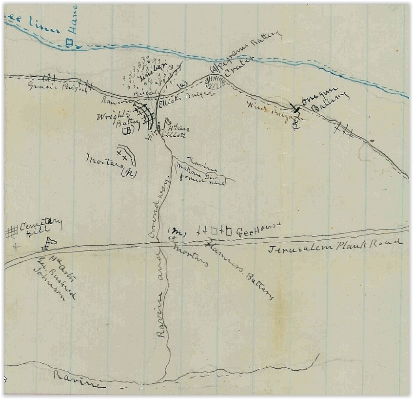
Detail of sketch above.
Letter from Major J. C. Coit to Colonel F.W. McMaster, August 2, 1879

In Southern Historical Society Papers, Vol. 10, 124-125

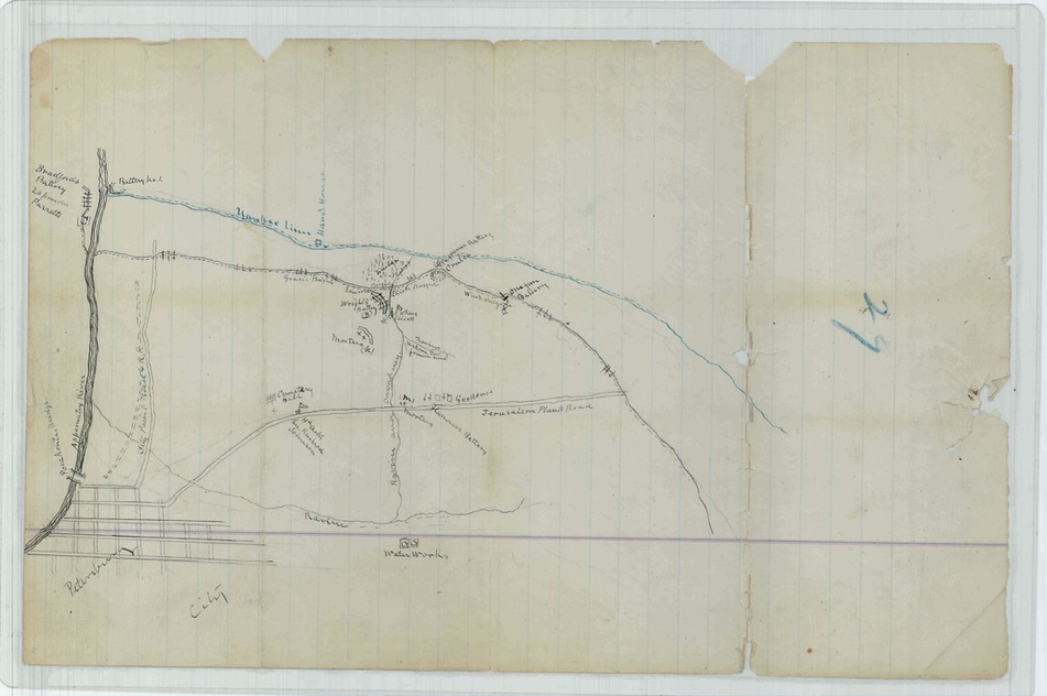
The salient marked A, when the mine was exploded, was occupied by Pegram's battery, four guns. The battery to the left of the crater, marked B, was Wright's, of Halifax, Va., four guns. The battery marked C, on north side of Appomattox, was Bradford's, of Mississippi, four 20-pounder Parrotts.

This battery was opposite the enemy's battery No. 1, and was intended  to enfilade their lines as far as the Hare house and beyond.

I see by the May No., 1878, Southern Historical papers that Captain Flanner's North Carolina battery occupied that position. General Bushrod Johnson's headquarters was upon the Jerusalem plank road, near the cemetery, and is marked in the sketch, General Elliott's and my own near the spring on the covered way, in rear of his brigade.

The artillery to the left of Wright's battery, and to the right of the one gun battery on the right of the crater, may have thrown a few shot into the enemy's lines in their front, but took no part in the engagement at the crater. During the day some artillery was brought from the right or rear and placed in position on Cemetery hill, but took no part in the engagement. The only artillery actually engaged was Wright's battery, the battery at the Gee house, and the two mortar batteries marked on sketch M, and the one gun battery to the right of crater (F C). The ravine in which General Mahone formed his division, before making the charge upon the crater, is shown in the sketch to the rear of Elliott's Headquarters, and extending out from the covered way in a direction between the crater and the Plank road.

Picture
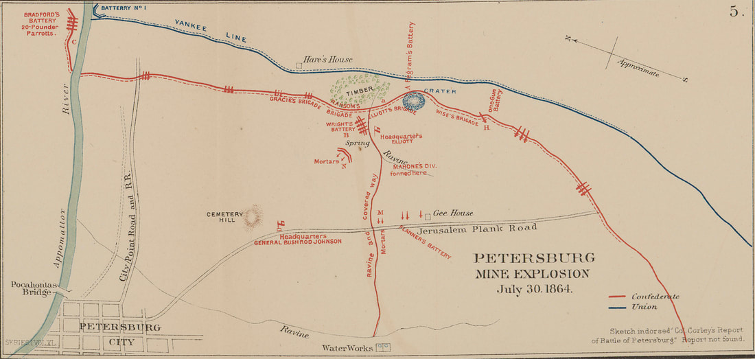
OR Atlas, Plate 78, Map 5. Petersburg Mine Explosion, July 30, 1864. Sketch endorsed "Col. Corley's [sic] Report of Battle of Petersburg". Report not found.
​The Crater
​
​Fields of Fire
Proudly powered by Weebly
Picture