A Few Notes on Leveled Earthworks
In many cases, earthworks were leveled on purpose to prevent the enemy from re-using them. This was the case with much of the Dimmock Line that was captured by the Federals in June 1864.
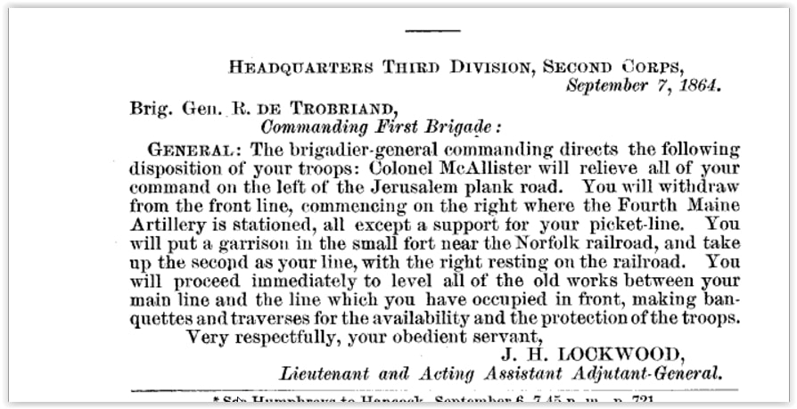
The War of the Rebellion: a compilation of the official ... ser.1:v.40:pt.1:Reports, p.293
... On the 12th the camp of general headquarters was moved from J ones’ to a more central position near Burchett’s and in rear of the center of the Ninth Corps.
On the 14th orders were issued to have the old works of the enemy demolished. This had been his advanced position, and the first to be taken by assault. The redoubts and batteries, in fact the whole intrenched line, had been beautifully planned and constructed at a much earlier period, in view of the probability of a demonstration being made against Petersburg. The site selected was a most magnificent and commanding one, the natural lay of the open fields in front forming a most perfect glacis. Fortunately surveys were made of this line, and maps of the works preserved, a set of which will be appended.....
In mid- July, the II Corps destroyed both their own works and Confederate works.
N. MICHLER
Major of Engineers, U.S. Army.
Surgeon William Child, History of the 5th New Hampshire Volunteers, 1893
July 11, orders were received to move out of our rifle- pits that night to destroy the works in the vicinity of the Williams house and to mass the corps near. This was blind business to the troops, and many comments, suggestions,guesses and wise conclusions were made.
July 12, the corps moved out at 3 o'clock in the morning and massed in the neighborhood of the Williams house and
destroyed the works in compliance with orders. William Weston's diary on this date says: "The second and third
divisions of the Second Corps arrive. The movements of the corps are mysterious, and we cannot make out what they mean. To-day the corps is engaged in leveling the works all along in our front. Toward night we are sent out on a reconnaissance on the extreme left flank, march four or five miles, halt until midnight, and return. Then we start for the right, leaving only the cavalry pickets on the left. The works on this part of the line are all demolished and we are started for our original point in front of Petersburg. At 9:45 p. m., General Hancock had orders from army head-quarters directing him to move into position in rear of the Fifth Corps, and the Second Corps took position on right and left of the Norfolk road near a deserted house....
July 15, Weston says: "To-day we move a little to the right and erect tents. The whole division is out leveling breastworks. The works on the left of the Fifth Corps to the extreme left of the line for a distance of three or four miles are all leveled to the ground. Don't know what to make of it. For the first time since the first of June the sky is overcast with clouds indicating rain."
Meade’s Army: The Private Notebooks of Lt. Col. Theodore Lyman. Edited by David Lowe, The Kent State University Press: 2007, 232
July 14, Thursday
..."Tonight the Second Corps are destroying their old line, beyond the plank road, to take up the new line that trends S.E. from the new fort on that road, and past the Cheevers house. Also they are leveling the old rebel line lines, which we took in the first operations, whereby a number of bodies , in a terrible state, were uncovered; though, of course, again interred."