
The Taylor House "Spring Garden"
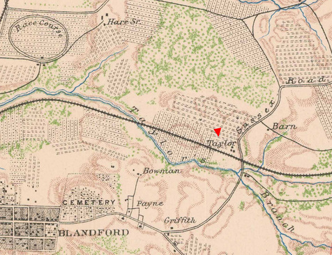
"The Taylor house [Spring Garden] ... was constructed in the third quarter of the eighteenth century, possibly by Richard Taylor. His son George received the house and associated plantation acreage in 1790. Following George's death c. 1816, various land speculators and farmers owned the property until it returned to the Taylor family in 1848. William Byrd Taylor owned the plantation and dwelling, which stood on a hill south of the town of Blandford, at the time of the Civil War. The 1863 Campbell map indicates three structures on the property, but there apparently were others.
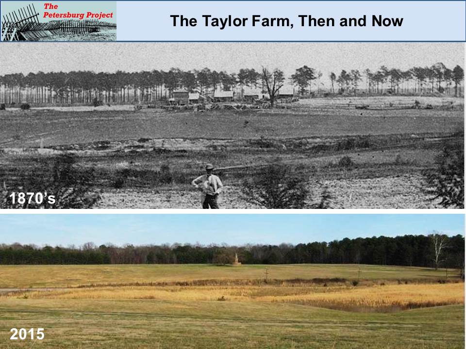
The Taylor dwelling lay in the path of the attacking Union army, as did so many other plantation manors and farmhouses. The Taylor plantation was overrun by Union troops on June 18—as reflected in the following excerpt from the official report of General Wilcox, a Union division commander in the Ninth Corps—and remained behind Union lines for the duration of the siege:
'...the division had a severe engagement, lasting nearly all day, moving up to, across, and beyond the deep cut of the Norfolk railroad, in front of the Taylor house, driving the enemy into his new works, not withstanding our very heavy loss, and finally establishing ourselves nearer to the enemy than any other portion of the army.' (O.R. Series I, Vol. 40, Part 1:571)
The Taylor dwelling was destroyed by fire the morning of June 18th:
We moved forward into the woods and then through them, without seeing any foe. Having halted and taken a survey, we
went to the edge of an oat-field, partially covered by rising ground, and from there we could see, at a little distance in front, burning buildings, which the enemy had just fired. We continued our advance; and, having moved through the oat-field and struck the high ground, we were met by a hot fire. I ordered the men forward, and we went across the field, and took position behind a fence which ran along by the burning buildings.
History of the Sixth New Hampshire Regiment in the War for the Union , Lyman Jackman, 1891, p. 298
"The dwelling of William Taylor, Esq., known as "Spring Garden," was destroyed by order of our authorities as a military necessity."
Richmond Examiner, June 21, 1864 (http://www.beyondthecrater.com/resources/np/1864-np/jun-64-np/np-18640621-richmond-examiner-the-fighting-about-petersburg-june-17-19/).
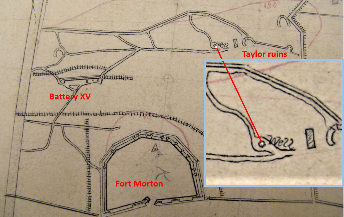
The site became known as the "Chimneys" in Union reports and on Union maps. The Michler map indicates the surrounding earthworks but does not mention Taylor.
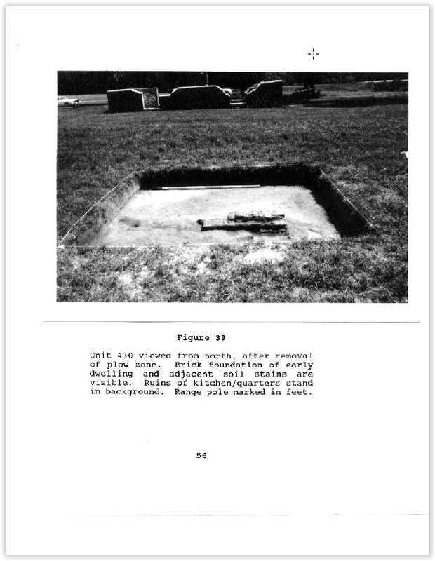
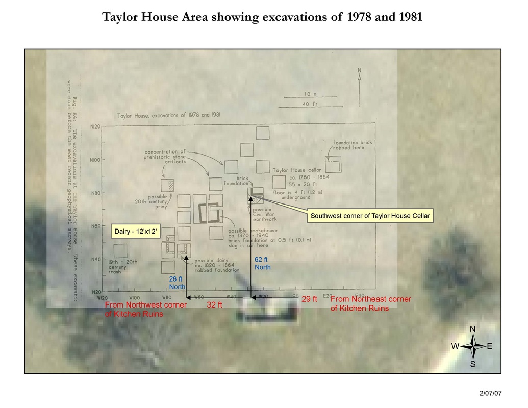
William Taylor returned to the property and constructed a modest frame dwelling on the brick foundations of his former kitchen. He resided on the property until his death in 1875. A dairy farm occupied the property in the early twentieth century. The NPS purchased the former Taylor farm and removed the post-Civil War Taylor dwelling, exposing the brick foundations of the former kitchen and probable slave quarters." From Archaeological Overview and Assessment of the Main Unit, Petersburg National Battlefield, Virginia Blades 2001.
The Taylor dwelling lay in the path of the attacking Union army, as did so many other plantation manors and farmhouses. The Taylor plantation was overrun by Union troops on June 18—as reflected in the following excerpt from the official report of General Wilcox, a Union division commander in the Ninth Corps—and remained behind Union lines for the duration of the siege:
'...the division had a severe engagement, lasting nearly all day, moving up to, across, and beyond the deep cut of the Norfolk railroad, in front of the Taylor house, driving the enemy into his new works, not withstanding our very heavy loss, and finally establishing ourselves nearer to the enemy than any other portion of the army.' (O.R. Series I, Vol. 40, Part 1:571)
The Taylor dwelling was destroyed by fire the morning of June 18th:
We moved forward into the woods and then through them, without seeing any foe. Having halted and taken a survey, we
went to the edge of an oat-field, partially covered by rising ground, and from there we could see, at a little distance in front, burning buildings, which the enemy had just fired. We continued our advance; and, having moved through the oat-field and struck the high ground, we were met by a hot fire. I ordered the men forward, and we went across the field, and took position behind a fence which ran along by the burning buildings.
History of the Sixth New Hampshire Regiment in the War for the Union , Lyman Jackman, 1891, p. 298
"The dwelling of William Taylor, Esq., known as "Spring Garden," was destroyed by order of our authorities as a military necessity."
Richmond Examiner, June 21, 1864 (http://www.beyondthecrater.com/resources/np/1864-np/jun-64-np/np-18640621-richmond-examiner-the-fighting-about-petersburg-june-17-19/).
The site became known as the "Chimneys" in Union reports and on Union maps. The Michler map indicates the surrounding earthworks but does not mention Taylor.
William Taylor returned to the property and constructed a modest frame dwelling on the brick foundations of his former kitchen. He resided on the property until his death in 1875. A dairy farm occupied the property in the early twentieth century. The NPS purchased the former Taylor farm and removed the post-Civil War Taylor dwelling, exposing the brick foundations of the former kitchen and probable slave quarters." From Archaeological Overview and Assessment of the Main Unit, Petersburg National Battlefield, Virginia Blades 2001.
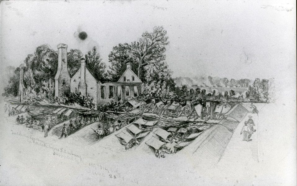
"Twitchell's battery in position before Petersburg, supported by the 109th New York volunteers, June 25, 1864." Orlando Willcox Collection. This drawing by aide de camp Andrew McCallum, shows partially destroyed buildings on the Taylor farm.
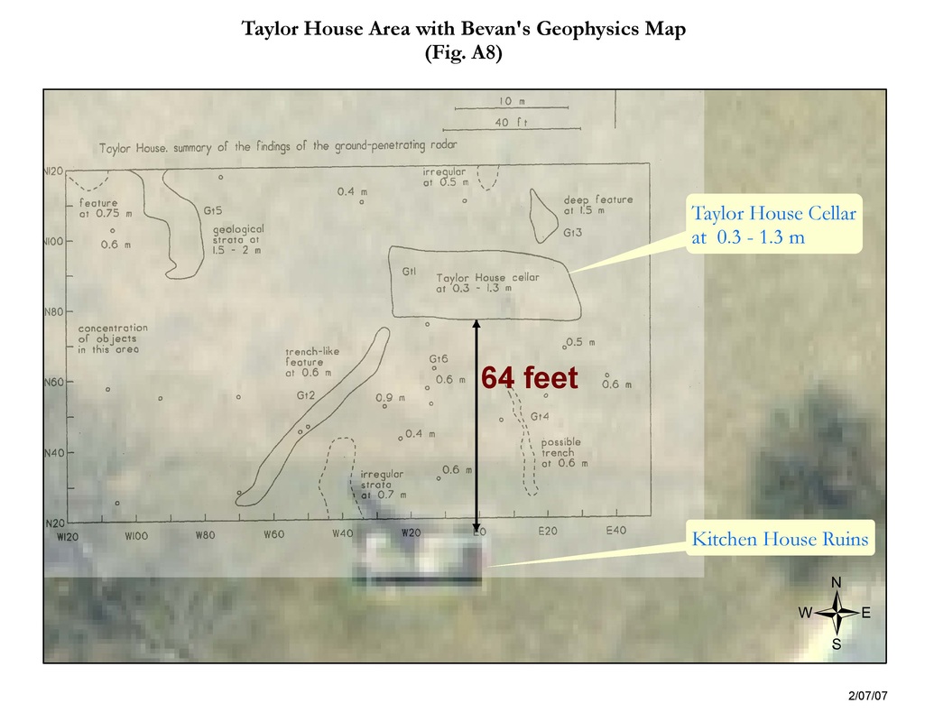
In 1998 and 1999, the NPS Northeast Region archeology program groundtruthed the geophysical work as reported by Orr and Steele (2011). Archeologists Bruce Bevan and Julie Steele did additional geophysical work to verify the locations of Union Battery XIV and a major Federal covered way that played a prominent role in the Battle of the Crater.
|
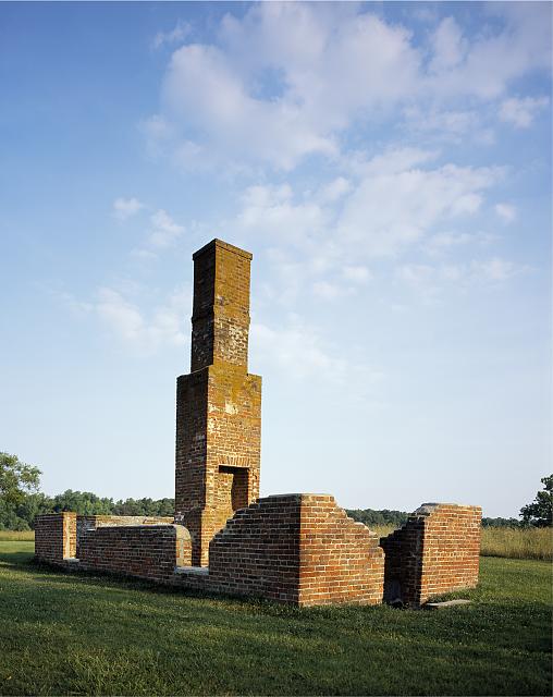
Ruins of Taylor House "Spring Hill" (kitchen), Petersburg National Battlefield, photograph by Carol M. Highsmith.
|
A Taylor Well Reappears in 2018!
LC cw0607200, details. In the winter of 2018 a hole opened up in the grass near the Taylor House ruins, revealing a brick lined well that was unknown during the National Park Service era. We won't know for sure without archeological exploration, but this well aligns with a well noted on the manuscript Michler map. No other wells are specifically noted on the war time or immediate post war maps. This well was at the front and incorporated into a U.S. communication trench.
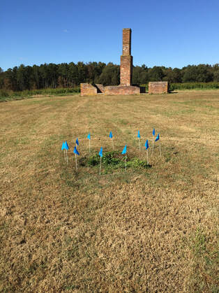
Well with post war Taylor chimney in the background.
|
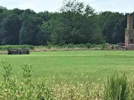
The well is now surrounded by a split rail fence.
|
-- Photographs -- Fort Morton and Baxter Road
-- Paper -- Battlefield Landscapes, Five Examples
-- Paper -- Bevan on Geophysics at Fort Morton
--Paper--Bevan on Geophysics at the Taylor Housewww.researchgate.net/publication/272488100_A_ground-penetrating_radar_survey_at_the_Taylor_House_Petersburg_National_Battlefield_Virginia
-- Paper -- Battlefield Landscapes, Five Examples
-- Paper -- Bevan on Geophysics at Fort Morton
--Paper--Bevan on Geophysics at the Taylor Housewww.researchgate.net/publication/272488100_A_ground-penetrating_radar_survey_at_the_Taylor_House_Petersburg_National_Battlefield_Virginia
