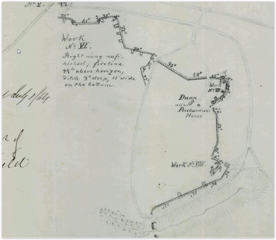
The Petersburg Project
  • Home
    • About Us
  • Blog and Updates
  • Petersburg Panorama 1865
  • Steeples of Petersburg
  • The Mine Explosion and its Crater
  • Petersburg in Pencil and Ink
    • Alfred R. Waud, Special Artist at Petersburg >
      • Waud Drawing of 5th Corps Fortifications
    • William Waud, Special Artist
    • Charles H. Chapin, Special Artist
    • Joseph Becker, Special Artist at Petersburg
    • Edwin Forbes, Special Artist at Petersburg
    • Winslow Homer, Special Artist
    • Edward Mullen, Special Artist at Petersburg
    • Andrew W. Warren, Special Artist
    • Enlisted Artists >
      • Charles Wellington Reed
      • Andrew McCallum
      • Francis Knowles
      • James William Pattison
      • Herbert Valentine
      • Howard A. Camp
  • Petersburg Photographs --So Many!
    • Working with Photographs
    • City Point
    • City Point Wharf Explosion, Aug. 9, 1864
    • Fort Rice?? We don't think so!
    • Federal Picket Line, Jerusalem Plank Road
    • Egbert Guy Fowx, Photographer at Petersburg
    • Timothy O'Sullivan, Photographer at Petersburg >
      • Fort Morton and Baxter Road Group
      • Fort Haskell Panorama
      • Fort Stedman Group
      • Gracie's Salient Group
      • Bombproofs behind Fort Haskell
      • Camp of the 50th N. Y. Engineers
    • David Knox, Photographer at Petersburg
    • William Redish Powell, Photographer at Petersburg
    • John Reekie, Photographer at Petersburg
    • Thomas C. Roche, Photographer at Petersburg
    • Andrew J. Russell, Photographer at Petersburg >
      • "Fort Mahone" CS Batteries 25 & 27
  • U. S. Military Railroad
    • Terminus of Military R. R. at City Point
    • City Point to Clark's Station
    • Pitkin's Station to Shooting Hill
    • Hancock's Junction/Jerusalem Plank Road
    • Parke's Station
    • Warren's Station
    • Patrick's Station
  • Maps and Topogs
    • Grand Medicine Pow-wow
    • Michler's Reports from Topographical Department
    • John E. Weyss, Cartographer
    • William H. Paine, Cartographer
    • Gilbert Thompson
  • Confederate Maps
    • Confederate Defenses 1862
    • Gilmer-Campbell Maps, 1864
    • Stevens Map July 1864
    • Fields of Fire
    • Coit's map of the Crater Battlefield
  • Federal Maps
    • Army of the Potomac, Routes of the Corps to Petersburg
    • June 18, 1864-Federal Engineers Map
    • June 18, 1864, 18th Corps
    • June 21, 1864, Federal Engineers Map
    • June 22, 1864. Second Corps at Jerusalem Plank Road
    • June 30, 1864 -- XVIII Corps Map
    • June-July, Undated Federal Engineers Map-
    • July 1864 Map of XVIII Corps Lines
    • Crater, Native American Perspective of the Crater
    • August 28, 1864, Michler Map
    • September 30, 1864, Warren Map
    • October 1864, Two IX Corps Maps
    • Nov. 2, 1864, Army of the Potomac
    • 1864, Coast Survey Map of Petersburg
    • NEW 1865-1867, Manuscript Survey Maps
    • 1864-1867, Michler-Weyss, Siege of Petersburg
    • 1865-1867, Michler Map Series
    • 1871, Map of Recapture of Ft. Stedman
    • 1881, Boydton Plank Road
  • Confederate Forts and Batteries
    • Dimmock Line >
      • Priest Cap
      • French Rifle Pits
    • Fort Clifton
    • "Fort Mahone" CS Batteries 25 & 27
    • Confederate 8-inch Columbiad
    • Leadworks
  • Federal Forts and Batteries
    • Battery X
    • Fort Alexander Hayes
    • Fort Avery
    • Fort Conahey
    • Fort Davis & Battery XXII
    • Fort Fisher
    • Fort Meikel --Photographic Views
    • Fort Morton
    • Fort Patrick Kelly
    • Fort Sedgwick, better known as Fort Hell,
    • Fort Wadsworth -- the Evolution
    • Fort Willcox or Battery XVI
  • Battlefield Features
    • Aiken House
    • Armstrong's Mill
    • Avery House
    • Bailey/Johnston Farm
    • Blandford Church
    • Broadway Landing, Appomattox River
    • The Crater
    • Cummings House
    • Dams and Inundations
    • WW Davis Farm
    • Dunn House
    • Friend House >
      • View from Friend House toward Gibben complex and Petersburg
    • Gibbons Properties
    • Globe Tavern / Weldon Railroad
    • Gregory House
    • Griffith Farm
    • Gurley House
    • Hare House
    • Hare House Hill
    • The "Horseshoe"
    • Jones House
    • Jordan House
    • Newmarket Racecourse
    • Pegram's Farm
    • Peebles Farm, Pegrams Farm, Poplar Springs Church
    • Shands House
    • Taylor Farm >
      • The Ice House
      • Surviving Taylor Barn
    • Williams House
  • Signal Towers and Trees
    • Some Operations of the Signal Corps at Petersburg
  • Archeology
    • Geology of the Crater
    • Fieldwork -- Petersburg
    • Civil War Sinks
    • Deserted Confederate Camp
    • Gracie's Countermine
    • LIDAR Forts and Batteries
  • Articles, Papers, Presentations
    • Shiman: A Note on Maps
    • The Siege Landscape: Through Fire and Ice at Petersburg
    • "The Rebel in the Road"
    • "A Strange Sort of Warfare Underground"
    • Lost Trenches of Petersburg: June 17
    • Between the Lines
    • Combat Trenching: An Introduction
    • Lowe -- Post-War Topographical Survey
    • Civil War Maps and Landscapes -- Observations
  • Kittens, Puppies & Ponies
  • Executions!
  • Notes on Leveled Earthworks
  • Civil War Combat Trenching
  • Depot Hospital at City Point
  • Dimmock Battery 5 Photographs
  • Pontoon Bridges
  • The Great Pontoon Bridge Across James River
  • Appomattox Mill Photographs

The Dunn House

"The Dunn house remains an enigmatic feature of the landscape from the standpoint of historical documentation.  The Dunn house was located south of the junction of the Prince George Court House and Jordan's Point roads, near Dimmock Battery 11.  ... However, James A. Dunn appears in both the 1860 Virginia personal property tax and the 1860 U.S. Census.  The personal property tax indicates that Dunn owned 9 adult slaves.  The Census data (U.S. Census, PG Co., p. 67) record that Dunn resided in dwelling no. 555 as a farmer with real estate valued at $8000 but no personal estate. " Exotic yucca plants grow on the site today, but no physical trace of the house is visible. From: An Archaeological Overview and Assessment of the Main Unit, Petersburg National Battlefield, Virginia, National Park Service, 2001.

..."it is unclear if the Dunn residence survived the Civil War. However, there are two indications that it may not have. First, in the 1870 census James and Sarah Dunn were living in the 6th Ward, 1st District of Petersburg. He was a book keeper.[i] The 1880 census shows that the Dunns remained in Petersburg, then in the third ward of the city.[ii] The other shred of evidence of the house’s possible Civil War destruction is that it is not shown on the 1894 USGS map."  From James A. Dunn House. Emmanuel Dabney, National Park Service, 2009.


[i] 1870 U.S. Census, Dinwiddie County, Virginia, 381.

[ii] 1880 U.S. Census, Dinwiddie County, Virginia, 326.


Picture
01229. Battery 11 of the Confederate Dimmock Line at the Dunn House captured June 15th, 1864. [ http://hdl.loc.gov/loc.pnp/cwpb.01229 ]
Picture
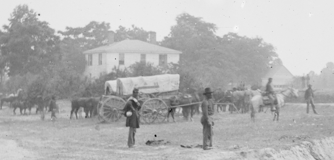
01229. Dunn House, a two-story frame house with double chimneys and outbuildings. Detail from the above photo.

Picture
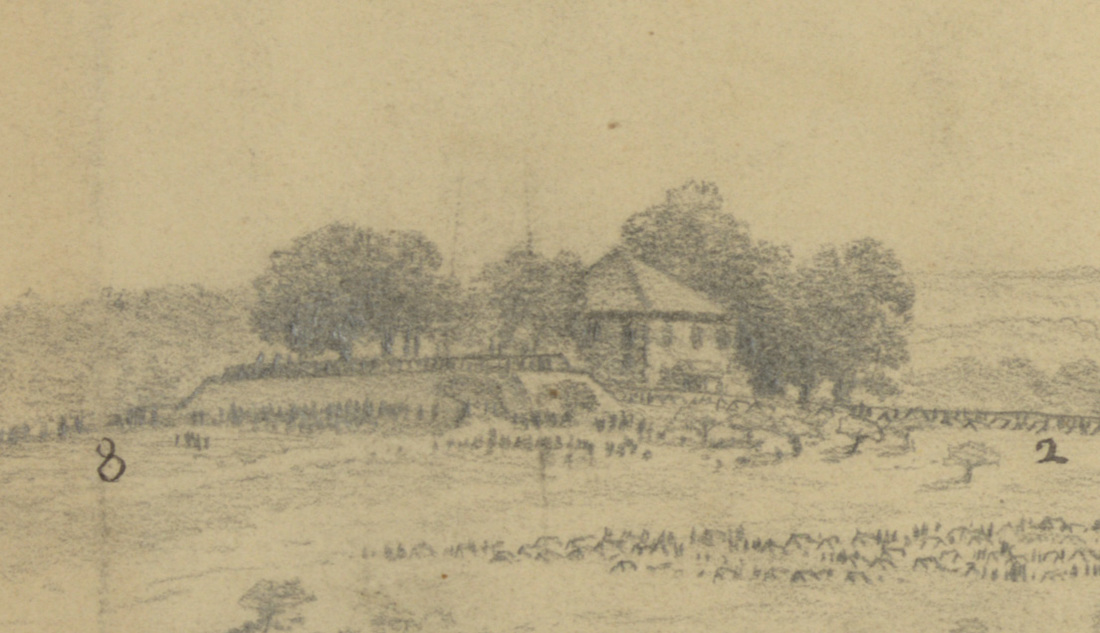
Dunn House and Confederate Battery Number 11. Drawing by Edwin Forbes. [ http://www.loc.gov/pictures/item/2004661586/ ]
Picture
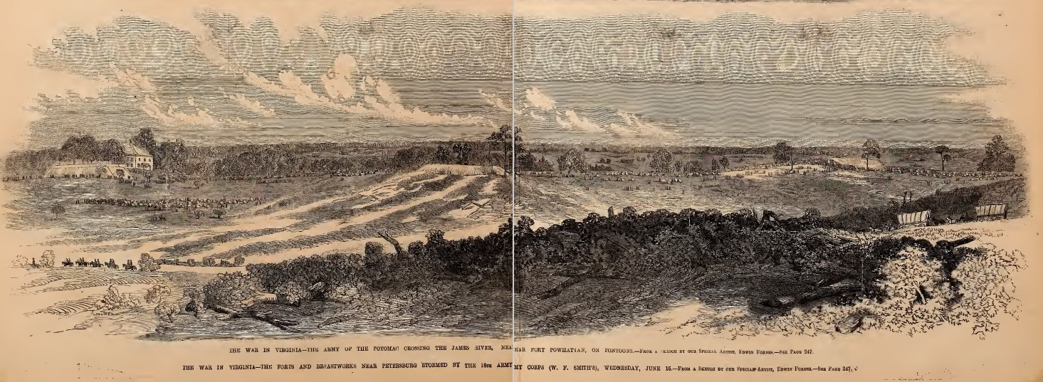
Section of the Dimmock Line from a sketch by Edwin Forbes, woodcut published in Frank Leslie's Illustrated Newspaper, July 9, 1864. A zoomable image is added below.
Picture
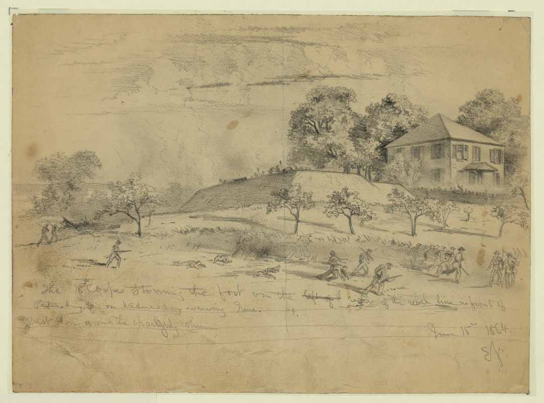
Dunn House and Confederate Battery 11, drawn by Alfred R. Waud.
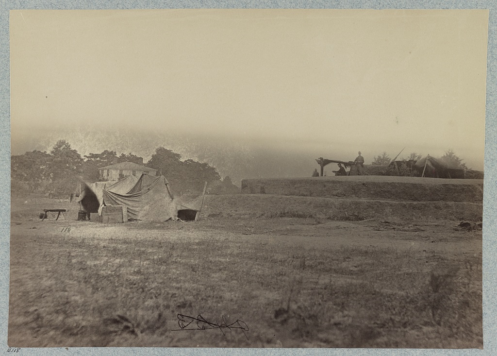
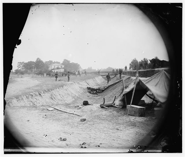
Picture
32422. "Outer line of Confederate fortifications, in front of Petersburg, Va., captured by 18th Army Corps, June 15, 1864" LC LOT 4166-E, no. 22 [P&P] Dunn House in the left distance behind the tents.
Picture

Dunn "alias Richardson" House shown on Federal map dated July 1, 1864.  National Archives RG 77. 150-49-B.  The Confederate batteries shown on this plan were eventually numbered differently.  The work east of the Dunn house was Battery 11.

Proudly powered by Weebly
Picture