The Petersburg Project
  • Home
    • About Us
  • Blog and Updates
  • Postwar Visit to the Battlefields 1866
  • Civil War Combat Trenching
  • Views of the City of Petersburg
    • Petersburg Panorama 1865
    • Steeples of Petersburg
    • Petersburg Mill Photographs
  • The Mine Explosion and its Crater
  • Petersburg in Pencil and Ink
    • Alfred R. Waud, Special Artist at Petersburg >
      • Waud Drawing of 5th Corps Fortifications
    • William Waud, Special Artist
    • Charles H. Chapin, Special Artist
    • Joseph Becker, Special Artist at Petersburg
    • Edwin Forbes, Special Artist at Petersburg
    • Winslow Homer, Special Artist
    • Edward Mullen, Special Artist at Petersburg
    • Andrew W. Warren, Special Artist
    • Enlisted Artists >
      • Charles Wellington Reed
      • Andrew McCallum
      • Francis Knowles
      • James William Pattison
      • Herbert Valentine
      • Howard A. Camp
  • Petersburg Photographs --So Many!
    • Dimmock Battery 5 Photographs >
      • Working with Photographs
    • City Point
    • City Point Wharf Explosion, Aug. 9, 1864
    • Fort Rice?? We don't think so!
    • Federal Picket Line, Jerusalem Plank Road
    • Egbert Guy Fowx, Photographer at Petersburg
    • Timothy O'Sullivan, Photographer at Petersburg >
      • Harrison's Creek USCT Camps
      • Fort Morton and Baxter Road Group
      • Fort Haskell Panorama and Bomb Proofs
      • Fort Stedman Group
      • Gracie's Salient Group
      • Camp of the 50th N. Y. Engineers
    • David Knox, Photographer at Petersburg
    • William Redish Pywell, Photographer at Petersburg
    • John Reekie, Photographer at Petersburg
    • Thomas C. Roche, Photographer at Petersburg
    • Andrew J. Russell, Photographer at Petersburg >
      • "Fort Mahone" CS Batteries 25 & 27
  • U. S. Military Railroad
    • Terminus of Military R. R. at City Point
    • City Point to Clark's Station
    • Pitkin's Station to Shooting Hill
    • Hancock's Junction/Jerusalem Plank Road
    • Parke's Station
    • Warren's Station
    • Patrick's Station
  • Topographical Engineers -- Our Heroes
    • Grand Medicine Pow-wow
    • Michler's Reports from Topographical Department
    • John E. Weyss, Cartographer
    • William H. Paine, Cartographer
    • Gilbert Thompson
    • Albert Hanry Campbell, C.S.A. Cartographer
  • Confederate Maps
    • Confederate Defenses 1862
    • Gilmer-Campbell Maps, 1864
    • Stevens Map July 1864
    • Fields of Fire
    • Campbell Dinwiddie County 1864
    • Coit's map of the Crater Battlefield
  • Federal Maps
    • Army of the Potomac, Routes of the Corps to Petersburg
    • June 9 1864, Kautz Attack
    • June 18, 1864-Federal Engineers Maps
    • June 18, 1864, 18th Corps
    • June 19, 1864, Engineers Map
    • June 21, 1864, Federal Engineers Maps
    • June 22, 1864. Second Corps at Jerusalem Plank Road
    • June 29, 1864. Dept of VA and NC
    • June 30, 1864 -- XVIII Corps Map
    • June-July, Undated Federal Engineers Map-
    • July 29, 1864, Engineers Map, Annotated
    • July 1864 Map of XVIII Corps Lines
    • Crater, Native American Perspective of the Crater
    • August 1864, Michie Map - Bermuda 100
    • August 28, 1864, Michler Map
    • Aug.-Nov. 1864 Two Base Maps
    • September 13, 1864, Recon Map
    • Sept. 13-Oct.25 versions. Redoubts and Batteries
    • September 30, 1864, Warren Map
    • October 1864, Two IX Corps Maps
    • October 20, 1864. Benham's map of defenses of City Point
    • Nov. 2, 1864, Army of the Potomac
    • 1864, Coast Survey Map of Petersburg
    • Michler Map Series 1865-1867
    • 1864-1867, Michler-Weyss, Siege of Petersburg
    • 1865-1867, Manuscript Survey Maps
    • 1871, Map of Recapture of Ft. Stedman
    • 1881, Boydton Plank Road
  • Confederate Forts and Batteries
    • Dimmock Line >
      • Priest Cap
      • French Rifle Pits
    • Fort Clifton
    • "Fort Mahone" CS Batteries 25 & 27
    • Confederate 8-inch Columbiad
    • Leadworks
  • Federal Forts and Batteries
    • Union Battery Ten (X)
    • Fort Alexander Hayes
    • Fort Avery
    • Fort Conahey
    • Fort Davis & Battery XXII
    • Fort Fisher
    • Fort Meikel --Photographic Views
    • Fort Morton
    • Fort Patrick Kelly
    • Fort Sedgwick, better known as Fort Hell,
    • Fort Wadsworth -- the Evolution
    • Fort Willcox or Battery XVI
  • Battlefield Features
    • Aiken House
    • Armstrong's Mill
    • Avery House
    • Bailey/Johnston Farm
    • Blandford Church
    • Broadway Landing, Appomattox River
    • The Crater
    • Cummings House
    • Dams and Inundations
    • WW Davis Farm
    • Dunn House
    • Friend House >
      • View from Friend House toward Gibben complex and Petersburg
    • Gibbons Properties
    • Globe Tavern / Weldon Railroad
    • Gregory House
    • Griffith Farm
    • Gurley House
    • Hare House Hill
    • The "Horseshoe"
    • Jerusalem Plank Road
    • Jones House
    • Jordan House
    • Newmarket Racecourse
    • Pegram's Farm
    • Peebles Farm, Pegrams Farm, Poplar Springs Church
    • Shands House
    • Taylor Farm >
      • The Ice House
      • Surviving Taylor Barn
    • Williams House
  • Signal Towers and Trees
    • Some Operations of the Signal Corps at Petersburg
  • Archeology
    • Geology of the Crater
    • Fieldwork -- Petersburg
    • Civil War Sinks
    • Deserted Confederate Camp
    • Gracie's Countermine
    • LIDAR Forts and Batteries
  • Articles, Papers, Presentations
    • Shiman: A Note on Maps
    • The Siege Landscape: Through Fire and Ice at Petersburg
    • "The Rebel in the Road"
    • "A Strange Sort of Warfare Underground"
    • Lost Trenches of Petersburg: June 17
    • Between the Lines
    • Combat Trenching: An Introduction
    • Lowe -- Post-War Topographical Survey
    • Civil War Maps and Landscapes -- Observations
  • Kittens, Puppies & Ponies
  • Executions!
  • Notes on Leveled Earthworks
  • Depot Hospital at City Point
  • Pontoon Bridges
  • The Great Pontoon Bridge Across James River
  • Captain Robert Davis CSA
The Petersburg Project uses photographic image id's from the Library of Congress for searching. The easiest way to search photographs is to input the numerical id. It is not technically correct, but it gets results. For example, "00518" brings up a distinct photo with less work than trying to reach the negative image.
​
​

Photographic Images of the Siege of Petersburg


A major source for us on the siege of Petersburg has been the photographic images made during and after the campaign -- many of them literally on the day the siege ended. Various photographers produced hundreds of images, for the Union army and for commercial sale. Many are of groups of soldiers, camps, and headquarters; others show scenes in and around the city of Petersburg, showing shell-damaged structures and scenes of interest.  For our purposes, the most useful have been the images taken of the siegeworks of both sides, as well as the numerous scenes from the battlefield of the 9th Corps' attack up the Jerusalem Plank Road on April 2nd, 1865.  Most have long been misidentified or unidentified.  We managed to identify nearly all of them, including the subject of the scene and the exact location of the camera. The photographs have given us an excellent understanding of the terrain, the engineering methods and materials, and the state of the art in both siege construction and battlefield entrenchment.

What makes these images especially valuable is the fact that many of them are very high-resolution scans of the original glass-plate negatives that the Library of Congress produced and made freely available on its website. The clarity of these photographs is remarkable, even when zoomed in 500 percent or more.  Photo editing software has allowed us to bring out details that in some cases are too small or too faded to be seen by the naked eye, ranging from distant forts and batteries to rifle loopholes. Even after studying them for years, we are still learning to interpret them and pulling out new information . In this way, the Petersburg photographs have literally opened up a whole new vista on that campaign and on trench warfare in the 1860s.
       

Working with the Photographs


The Photographers
  • ​Timothy O'Sullivan
  • John Reekie
  • Thomas C. Roche
  • Andrew Russell
  • David Knox

​​Image Groupings

The numerous photographs taken of the siege of Petersburg can be isolated into groupings or clusters -- photographs taken about the same time and in the same general area, usually by the same photographer. Petersburg Project researchers (and others before us) have identified some of the principal groupings.

​Union Scenes:
  • The Dimmock Line - various photographers and dates
  • ​Fort Stedman/Battery X - O'Sullivan, April 1865
  • Fort Haskell - O'Sullivan, April 1865
  • Baxter Road Forts - O'Sullivan, April 1865
  • Fort Sedgwick (Fort Hell) - various photographers, April 1865
  • Picket line in front of Fort Hell - Russell, April 1865
  • Camps & bombproofs - O'Sullivan, August 1864
  • Miscellany - various photographers, April 1865
​

​Confederate Scenes:
  • Gracie's Salient - O'Sullivan
  • The Crater - unknown, April? 1865
  • Battery 25 - Russell, April 1865
  • Battery 27 - Russell, April 1865
  • Dead Confederate soldiers - Roche, April 1865
  • Miscellany - various photographers, April 1865
  • Petersburg - Reekie, April 1865
  • Appomattox River views - O'Sullivan, April 1865
Picture
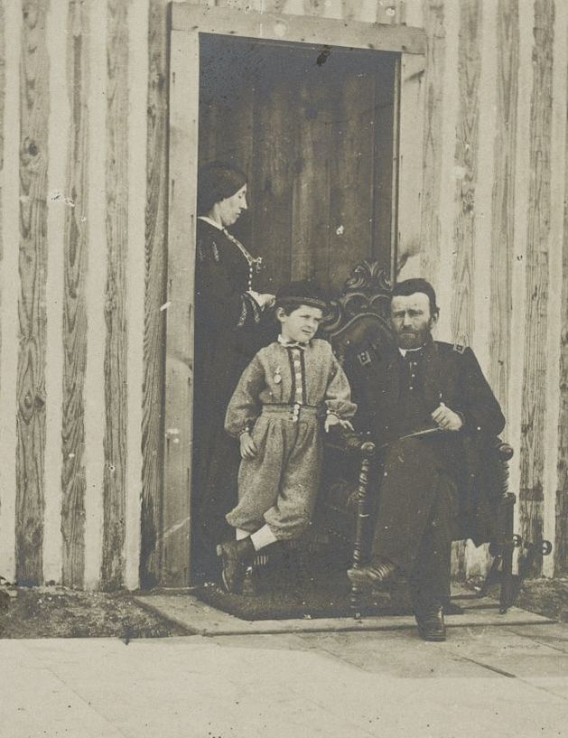
Detail from LC LC-DIG-ppmsca-33024 (digital file from original item, top left) LC-B8184-2545 (b&w film copy neg.
Picture
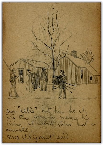
LC. Manuscript Division, Charles Wellington Reed papers.
Now "Ulis" let him do it.  It's the way he makes his living.  It won't take but a moment".  Julia Grant to a reluctant-to-be- photographed Ulysses S. Grant, as recorded by sketch artist/ enlisted man Charles Wellington Reed at City Point.  ​
Picture
Proudly powered by Weebly