The Petersburg Project
  • Home
    • About Us
  • Blog and Updates
  • The Crater
  • Petersburg in Pencil and Ink
    • Alfred R. Waud, Special Artist at Petersburg >
      • In Front of Petersburg
      • Waud Drawing of 5th Corps Fortifications
      • Rives Salient ("Fort Mahone")
      • Soldiers' Wells
      • The Mine Explosion
    • William Waud, Special Artist
    • Charles H. Chapin, Special Artist
    • Edwin Forbes, Special Artist at Petersburg
    • Joseph Becker, Special Artist at Petersburg
    • Edward Mullen, Special Artist at Petersburg
    • Andrew W. Warren, Special Artist
    • Winslow Homer, Special Artist
    • Enlisted Artists >
      • Charles Wellington Reed
      • Andrew McCallum
      • Francis Knowles
      • James William Pattison
      • Herbert Valentine
  • Petersburg Photographs --So Many!
    • Working with Photographs
    • Steeples of Petersburg
    • Petersburg Panorama 1865
    • City Point
    • City Point Wharf Explosion, Aug. 9, 1864
    • Fort Rice?? We don't think so!
    • Federal Picket Line, Jerusalem Plank Road
    • Timothy O'Sullivan, Photographer at Petersburg >
      • O'Sullivan and Vest Man
      • Fort Morton and Baxter Road Group
      • Fort Haskell Panorama
      • Fort Stedman Group
      • Gracie's Salient Group
      • Bombproofs behind Fort Haskell
      • Camp of the 50th N. Y. Engineers
    • John Reekie, Photographer for the Quartermaster Corps
    • Thomas C. Roche, Photographer at Petersburg
    • David Knox, Photographer at Petersburg
    • Andrew J. Russell, Photographer at Petersburg >
      • "Fort Mahone" CS Batteries 25 & 27
  • U. S. Military Railroad
    • Terminus of Military R. R. at City Point
    • City Point to Clark's Station
    • Pitkin's Station to Shooting Hill
    • Hancock's Junction/Jerusalem Plank Road
    • Parke's Station
    • Warren's Station
    • Patrick's Station
  • Maps and Topogs
    • Grand Medicine Pow-wow
    • Michler's Reports from Topographical Department
    • John E. Weyss, Cartographer
    • William H. Paine, Cartographer
    • Gilbert Thompson
  • Confederate Maps
    • Confederate Defenses 1862
    • Gilmer-Campbell Maps, 1864
    • Stevens Map July 1864
    • Fields of Fire
    • Coit's map of the Crater Battlefield
  • Federal Maps
    • June 18, 1864-Federal Engineers Map
    • June 21, 1864, Federal Engineers Map
    • June 22, 1864. Second Corps at Jerusalem Plank Road
    • June 30, 1864 -- XVIII Corps Map
    • Undated Federal Engineers Map--June-July, 1864
    • July 1864 Map of XVIII Corps Lines
    • 18th Corps, June 18, 1864
    • Native American Perspective of the Crater
    • August 28, 1864, Michler Map
    • IX Corps, Peebles and Pegrams Farms Oct. 1864
    • Army of the Potomac, Nov. 2, 1864
    • 1864, Coast Survey Map of Petersburg
    • Army of the Potomac, Routes of the Corps to Petersburg
    • Manuscript Survey, 1865
    • Michler-Weyss, Siege of Petersburg
    • Michler Map Series 1865-1867
    • 1871, Map of Recapture of Ft. Stedman
    • 1881, Boydton Plank Road
  • Confederate Forts and Batteries
    • Dimmock Line >
      • Priest Cap
      • French Rifle Pits
    • Fort Clifton
    • Confederate Leadworks
  • Federal Forts and Batteries
    • Battery X
    • Fort Alexander Hayes
    • Fort Avery
    • Fort Conahey
    • Fort Davis & Battery XXII
    • Fort Fisher
    • Fort Meikel --Photographic Views
    • Fort Morton
    • Fort Patrick Kelly
    • Fort Sedgwick, better known as Fort Hell,
    • Fort Wadsworth -- the Evolution
    • Fort Willcox or Battery XVI
    • Hare House Hill
  • Battlefield Features
    • Aiken House
    • Avery House
    • Bailey/Johnston Farm
    • Blandford Church
    • Broadway Landing, Appomattox River
    • The Crater
    • Cummings House
    • Dams and Inundations
    • Dunn House
    • Friend House >
      • View from Friend House toward Gibben complex and Petersburg
    • Globe Tavern / Weldon Railroad
    • Gregory House
    • Griffith Farm
    • Gurley House
    • Hare House
    • The "Horseshoe"
    • Jones House
    • Jordan House
    • Pegram's Farm
    • Peebles Farm, Pegrams Farm, Poplar Springs Church
    • Shand House
    • Taylor Farm >
      • The Ice House
      • Surviving Taylor Barn
    • U. S. Engineers at the Williams House
    • Williams House
  • Signal Towers and Trees
    • Some Operations of the Signal Corps at Petersburg
  • Archeology
    • Geology of the Crater
    • Fieldwork -- Petersburg
    • Civil War Sinks
    • Deserted Confederate Camp
    • Gracie's Countermine
    • LIDAR Forts and Batteries
  • Articles, Papers, Presentations
    • Shiman: A Note on Maps
    • The Siege Landscape: Through Fire and Ice at Petersburg
    • "The Rebel in the Road"
    • "A Strange Sort of Warfare Underground"
    • Lost Trenches of Petersburg: June 17
    • Between the Lines
    • Combat Trenching: An Introduction
  • Encyclopedia
    • Glossary
    • The Battlefields
    • Siege Warfare
    • Union Lines
    • Confederate Lines
    • Combat >
      • June 30, 1864, Attack
      • Combat Entrenching
      • Trench Warfare in Civil War History
      • Chamberlain at Petersburg, June 18, 1864
  • Kittens, Puppies & Ponies
  • Executions!
  • Civil War Combat Trenching
  • Pontoon Bridges
  • Depot Hospital at City Point
  • New: Shot tower

The "Horseshoe":  Advanced U.S. Line on Blandford Hill, later site of the Crater.

​"The line in front of Fort Morton, where our brigade had fought on the evening of the 18th of June, was pushed up nearer to the rebel line than at any other point, being at one period only 125 yards from that line; and this advanced part of our line was commonly called by our men “the horseshoe."  Directly in front of “the horseshoe” and opposite to Fort Morton, upon a swell of ground arising some thirty-five or forty feet above Taylor’s Creek, was a Confederate fort, mounting four pieces of artillery, occupied by Pegram’s battery, supported by two battalions of South Carolina infantry.  This fort or battery formed a salient in the Confederate line, known as “Elliott’s Salient,” pushed forward beyond the general trend of their line, and we who had occupied the “horseshoe” during the month of July, were well aware that a tunnel or mine had been run from the bank of Taylor’s Creek, inside our line, under this fort."
​
The Story of the Twentieth Michigan Infantry, Byron M. Cutcheon, 1904, pg. 138.
Picture
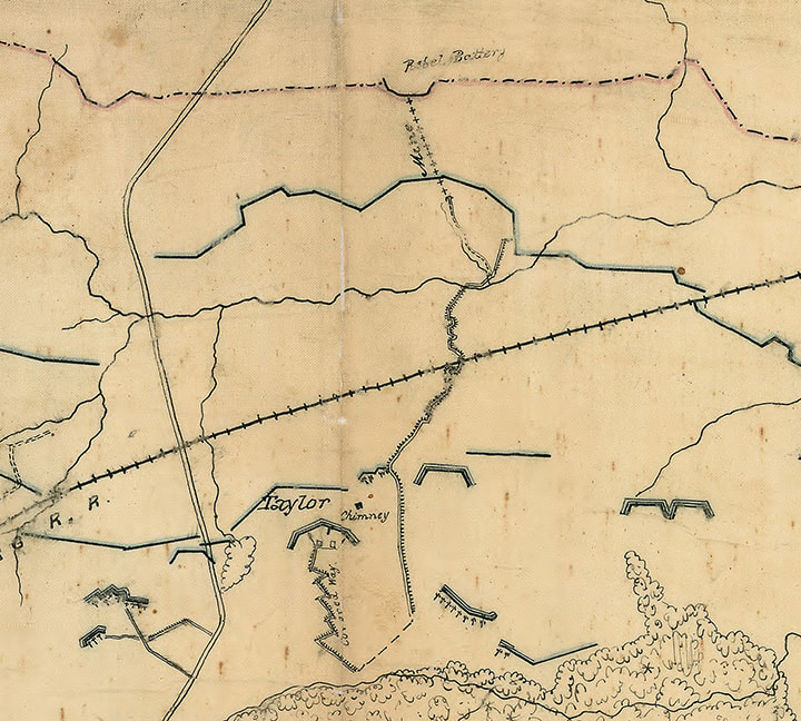
Detail from an early Federal map, showing the configuration of the "horseshoe" to the left of the Petersburg & Norfolk railroad cut. NARA RG 77.
Wednesday [June] 22nd [1864]
At 1 this morning we went out on the front line, relieving the occupants of the “horseshoe”, who in turn fell back to the rear, occupying our breastworks in the woods. The works are now strong enough to resist cannonballs, but the work goes on.  One half of our boys stand ready to repel attack, and keep up skirmish firing, while the other half keeps throwing out the sandy soil to add greater strength to our position.  We now have two well made lines, a front and rear, from ¼ to ½ a mile apart, which we are to occupy alternately. As daylight came, work was suspended, as it was impossible to expose our persons and not endanger our lives….
​
Diary of John Frederic Holahan, 45th Pennsylvania Volunteers.  Manuscript on file at Petersburg National Battlefield.
Picture
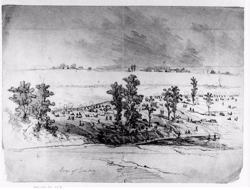
Recto: "Siege of Petersburg // 1 // 2 // 3 // 4." Verso: "View of the lines of the two contending armies before Petersburg from Fort Milroy [sic, actually Fort Morton] // 1 - second line of Rebel defense which the union troops failed to carry // 2 - Petersburg // 3 - Exploded mine and rebel line // 4 - Union line." Note: the railroad cut running across the foreground.

Picture
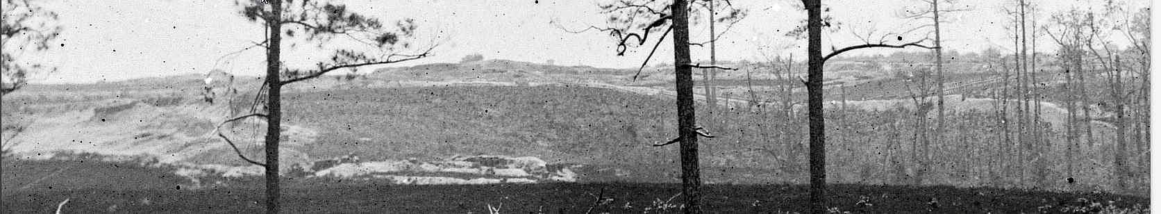
LC 01324 detail. View of the horseshoe from Fort Haskell. High point at center is the Crater and its surmounting trench.
Picture
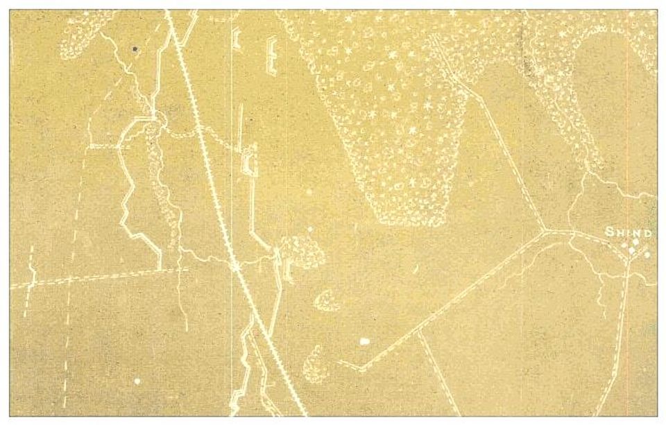
LC lva00194 detail. Another view of the "horseshoe" from a map dated August 28, 1864. This shows the covered way leading up to the mine entrance and the mine itself leading underneath the "Rebel Battery." Fort Morton is still an unenclosed battery at the site of the Taylor house ("chimney").
​Native American Perspective of the Crater
Picture
Proudly powered by Weebly
Picture