The Petersburg Project
  • Home
    • About Us
  • Blog and Updates
  • Postwar Visit to the Battlefields 1866
  • Civil War Combat Trenching
  • Views of the City of Petersburg
    • Petersburg Panorama 1865
    • Steeples of Petersburg
    • Petersburg Mill Photographs
  • The Mine Explosion and its Crater
  • Petersburg in Pencil and Ink
    • Alfred R. Waud, Special Artist at Petersburg >
      • Waud Drawing of 5th Corps Fortifications
    • William Waud, Special Artist
    • Charles H. Chapin, Special Artist
    • Joseph Becker, Special Artist at Petersburg
    • Edwin Forbes, Special Artist at Petersburg
    • Winslow Homer, Special Artist
    • Edward Mullen, Special Artist at Petersburg
    • Andrew W. Warren, Special Artist
    • Enlisted Artists >
      • Charles Wellington Reed
      • Andrew McCallum
      • Francis Knowles
      • James William Pattison
      • Herbert Valentine
      • Howard A. Camp
  • Petersburg Photographs --So Many!
    • Dimmock Battery 5 Photographs >
      • Working with Photographs
    • City Point
    • City Point Wharf Explosion, Aug. 9, 1864
    • Fort Rice?? We don't think so!
    • Federal Picket Line, Jerusalem Plank Road
    • Egbert Guy Fowx, Photographer at Petersburg
    • Timothy O'Sullivan, Photographer at Petersburg >
      • Harrison's Creek USCT Camps
      • Fort Morton and Baxter Road Group
      • Fort Haskell Panorama and Bomb Proofs
      • Fort Stedman Group
      • Gracie's Salient Group
      • Camp of the 50th N. Y. Engineers
    • David Knox, Photographer at Petersburg
    • William Redish Pywell, Photographer at Petersburg
    • John Reekie, Photographer at Petersburg
    • Thomas C. Roche, Photographer at Petersburg
    • Andrew J. Russell, Photographer at Petersburg >
      • "Fort Mahone" CS Batteries 25 & 27
  • U. S. Military Railroad
    • Terminus of Military R. R. at City Point
    • City Point to Clark's Station
    • Pitkin's Station to Shooting Hill
    • Hancock's Junction/Jerusalem Plank Road
    • Parke's Station
    • Warren's Station
    • Patrick's Station
  • Topographical Engineers -- Our Heroes
    • Grand Medicine Pow-wow
    • Michler's Reports from Topographical Department
    • John E. Weyss, Cartographer
    • William H. Paine, Cartographer
    • Gilbert Thompson
    • Albert Hanry Campbell, C.S.A. Cartographer
  • Confederate Maps
    • Confederate Defenses 1862
    • Gilmer-Campbell Maps, 1864
    • Stevens Map July 1864
    • Fields of Fire
    • Campbell Dinwiddie County 1864
    • Coit's map of the Crater Battlefield
  • Federal Maps
    • Army of the Potomac, Routes of the Corps to Petersburg
    • June 9 1864, Kautz Attack
    • June 18, 1864-Federal Engineers Maps
    • June 18, 1864, 18th Corps
    • June 19, 1864, Engineers Map
    • June 21, 1864, Federal Engineers Maps
    • June 22, 1864. Second Corps at Jerusalem Plank Road
    • June 29, 1864. Dept of VA and NC
    • June 30, 1864 -- XVIII Corps Map
    • June-July, Undated Federal Engineers Map-
    • July 29, 1864, Engineers Map, Annotated
    • July 1864 Map of XVIII Corps Lines
    • Crater, Native American Perspective of the Crater
    • August 1864, Michie Map - Bermuda 100
    • August 28, 1864, Michler Map
    • Aug.-Nov. 1864 Two Base Maps
    • September 13, 1864, Recon Map
    • Sept. 13-Oct.25 versions. Redoubts and Batteries
    • September 30, 1864, Warren Map
    • October 1864, Two IX Corps Maps
    • October 20, 1864. Benham's map of defenses of City Point
    • Nov. 2, 1864, Army of the Potomac
    • 1864, Coast Survey Map of Petersburg
    • Michler Map Series 1865-1867
    • 1864-1867, Michler-Weyss, Siege of Petersburg
    • 1865-1867, Manuscript Survey Maps
    • 1871, Map of Recapture of Ft. Stedman
    • 1881, Boydton Plank Road
  • Confederate Forts and Batteries
    • Dimmock Line >
      • Priest Cap
      • French Rifle Pits
    • Fort Clifton
    • "Fort Mahone" CS Batteries 25 & 27
    • Confederate 8-inch Columbiad
    • Leadworks
  • Federal Forts and Batteries
    • Union Battery Ten (X)
    • Fort Alexander Hayes
    • Fort Avery
    • Fort Conahey
    • Fort Davis & Battery XXII
    • Fort Fisher
    • Fort Meikel --Photographic Views
    • Fort Morton
    • Fort Patrick Kelly
    • Fort Sedgwick, better known as Fort Hell,
    • Fort Wadsworth -- the Evolution
    • Fort Willcox or Battery XVI
  • Battlefield Features
    • Aiken House
    • Armstrong's Mill
    • Avery House
    • Bailey/Johnston Farm
    • Blandford Church
    • Broadway Landing, Appomattox River
    • The Crater
    • Cummings House
    • Dams and Inundations
    • WW Davis Farm
    • Dunn House
    • Friend House >
      • View from Friend House toward Gibben complex and Petersburg
    • Gibbons Properties
    • Globe Tavern / Weldon Railroad
    • Gregory House
    • Griffith Farm
    • Gurley House
    • Hare House Hill
    • The "Horseshoe"
    • Jerusalem Plank Road
    • Jones House
    • Jordan House
    • Newmarket Racecourse
    • Pegram's Farm
    • Peebles Farm, Pegrams Farm, Poplar Springs Church
    • Shands House
    • Taylor Farm >
      • The Ice House
      • Surviving Taylor Barn
    • Williams House
  • Signal Towers and Trees
    • Some Operations of the Signal Corps at Petersburg
  • Archeology
    • Geology of the Crater
    • Fieldwork -- Petersburg
    • Civil War Sinks
    • Deserted Confederate Camp
    • Gracie's Countermine
    • LIDAR Forts and Batteries
  • Articles, Papers, Presentations
    • Shiman: A Note on Maps
    • The Siege Landscape: Through Fire and Ice at Petersburg
    • "The Rebel in the Road"
    • "A Strange Sort of Warfare Underground"
    • Lost Trenches of Petersburg: June 17
    • Between the Lines
    • Combat Trenching: An Introduction
    • Lowe -- Post-War Topographical Survey
    • Civil War Maps and Landscapes -- Observations
  • Kittens, Puppies & Ponies
  • Executions!
  • Notes on Leveled Earthworks
  • Depot Hospital at City Point
  • Pontoon Bridges
  • The Great Pontoon Bridge Across James River
  • Captain Robert Davis CSA
Picture

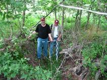
The Petersburg Project embraces a cross-disciplinary approach involving textual research, field surveys, archeological investigations, and detailed analyses of the contemporary maps and photographs. We are making use of some of the newest tools available, including LiDAR, high-resolution digital scans of old photographs, and geographical information systems (GIS); as well as some of the oldest, such as eyeballs and boot leather on the ground. Our methods are most similar to those of battlefield archaeology but we like to think we are "lurching ahead" in new directions. Sometimes, we may fall over. Oops. Our bad.

Our personal work will be freely available to all (with due credit). We believe a website is the best vehicle to share information, piece at a time. Here we explain our methods, lay out our evidence, and present our findings as well as random thoughts, ruminations, and hallucinations.  We intend the site to be a living document that will grow and evolve for years as we add material and make corrections.

Our desire is to advance knowledge and assist the activities, not just of historians who write, but also public historians, landowners, organizations, and government agencies who preserve and interpret the earthworks in their care. We believe that interest in the subject of military engineering and fortifications in particular is growing.

​We don't want to do this alone. We like trudging around the woods with like-minded folks, looking at historic piles of dirt, trying to get into the heads of the military engineers and the common soldiers of 1864-1865.

ABOUT US


Picture
Dr. Philip Shiman is a professional historian whose primary interest has been military engineering of all periods, but especially focusing on the evolution of field fortifications during the American Civil War. During the 1980s Dr. Shiman invested six summers as a seasonal interpreter at Petersburg National Battlefield, where he designed and oversaw the construction of a full-scale replica of the Union siege line that the park still maintains as a permanent exhibit at Tour Stop Six. (The park's display is informally referred to as "Fort Shiman.") In 1992 he cofounded the Civil War Fortification Study Group, a nonprofit organization dedicated to promoting the interpretation and preservation of Civil War earthworks. During his career he has lectured in public and professional military forums and participated in numerous engineering-related living history demonstrations. He has been described as the "Master of the Gabion." Although in his other life he studied the history of modern military technology for the US Department of Defense. Dr. Shiman holds degrees in history -- a B.A. from Yale and a Ph.D. from Duke University. He lives in Springfield, Virginia.


Picture
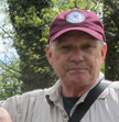
​David Lowe has been a National Park Service historian for the last 28 years and spent much of his career applying the technologies of geospatial analysis (GIS) and geographic positioning systems (GPS) to the study of historic battlefields. His work for the Civil War Sites Advisory Commission in the early 1990s led to methodologies used to survey battlefields today. The concepts he developed of "defining features," "study area," and "core area" have been used to determine the extent and condition of hundreds of battlefields from the War of 1812, the Revolution, and the American Civil War. In his work for the park service, he has supervised mapping of more than 130 miles of surviving fortifications. As co-founder of the Civil War Fortification Study Group, he has tramped over and documented many more miles of earthworks. Lowe has a BA in Anthropology from the Ohio State University and holds a masters degree in American history from George Mason University. He is editor of Meade's Army: the Private Notebooks of Lt. Col. Theodore Lyman (Kent State University Press, 2007). Lowe is currently retired and resides in Washington, D.C.


Picture
 Julia Steele grew up near Washington Crossing, PA, and developed an early interest in the Revolutionary War which expanded to the Civil War after family trips to Gettysburg.  At the start of her professional career she recorded and assessed WWII and Cold War sites in Alaska.  She joined the National Park Service Northeast Region Archeology Program in 1994 and has worked on Civil War era projects at Petersburg, Gettysburg, Fredericksburg, Spotsylvania and Cold Harbor.  She was part of a five year research project at Valley Forge, which led to reinterpretation of significant aspects of the encampment.  Since 2006, she has been Cultural Resource Manager at Petersburg National Battlefield, served as archaeologist for other Virginia parks and is now Chief of Resource Management at Petersburg. Steele has a B.A. in Anthropology from the University of Pennsylvania and a masters in Anthropology from Binghamton University. She has contributed publications, grey literature and presentations on military archaeology and other archaeology topics. She lives in Colonial Heights, Virginia. Julie retired in 2021 but remains active with the Petersburg Battlefield Foundation, the Petersburg Civil War Roundtable, and consults on archeology and history with the park.


Petersburg. IT'S A SIEGE !! And we're proud of it.

Picture
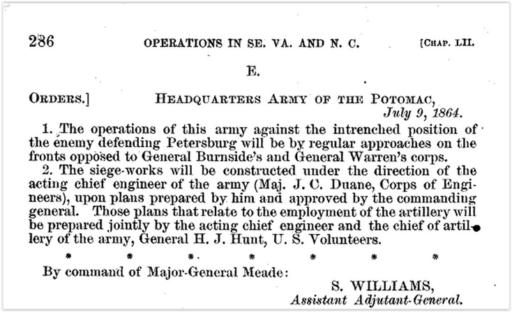
It's a siege! Official circular initiating siege operations. OR XL Part I.
Petersburg. Orders initiating siege operations. O.R. 40, 1: 286.

  • Proudly powered by Weebly


Picture
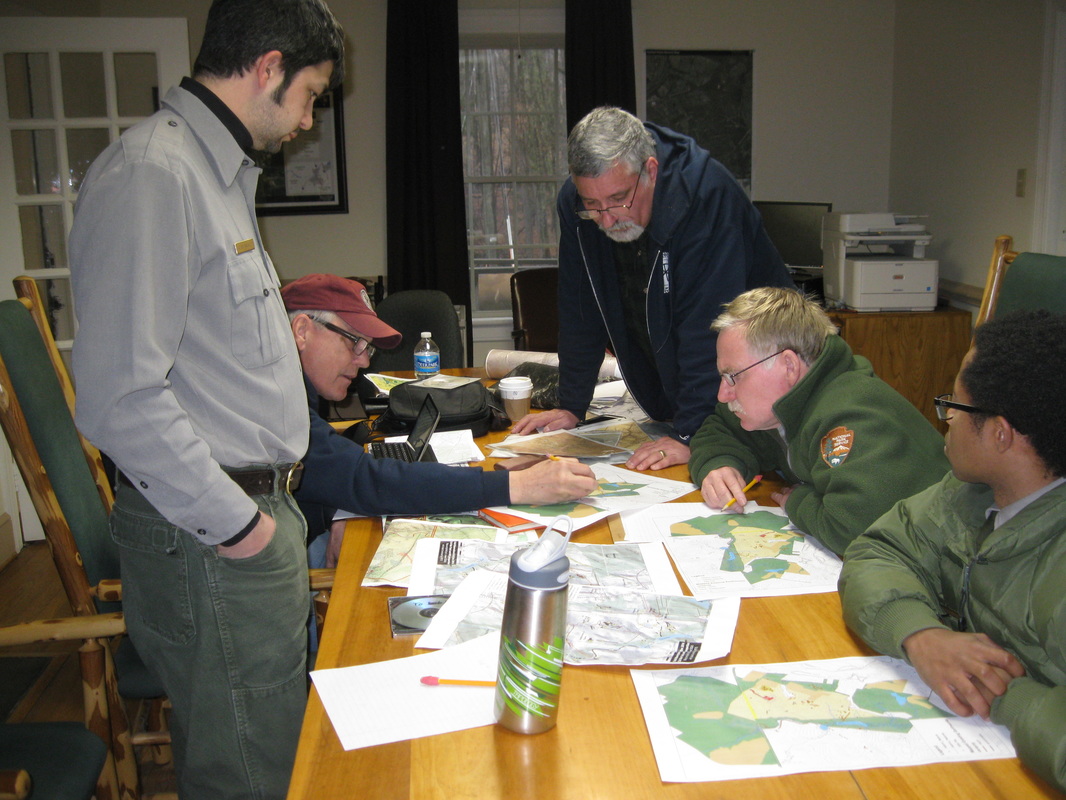
Comparing maps and notes about the fighting around Pegram's Farm, October 1864. L to R: Adam Baghetti, David Lowe, Phil Shiman, Dave Shockley, Emmanuel Dabney. 
Picture
Proudly powered by Weebly