
The Friend House
Friend house site: "The Nathaniel Friend house was known in the eighteenth and early nineteenth centuries as the estate of "White Hill," which was owned in the late eighteenth century by Robert Turnbull. The home was still owned by Nathaniel Friend and his family during the Civil War. The house survived the siege and remained standing into the early twentieth century, although the property and associated buildings sustained much damage. The house site is located in the woods west of the current maintenance area for the park. Several "old excavations" and an "old building excavation" may have related to the antebellum plantation, while "old concrete" foundations evidently are associated with later occupation of the property. One of these foundations is still visible. The continued occupation of the property into the twentieth century may have impacted the earlier colonial and pre-Civil War archaeological record." From: An Archaeological Overview and Assessment of the Main Unit, Petersburg National Battlefield, Virginia, National Park Service, 2001.
|
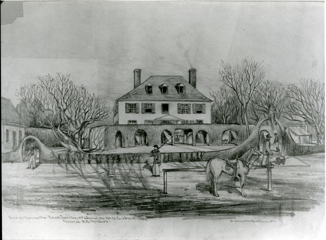
"Friend House Va. Headquarters 1st Division 9th A.C., Dec. 5th, 1864" Gen. O. B. Willcox" drawing by Andrew McCallum. Willcox Collection.
|
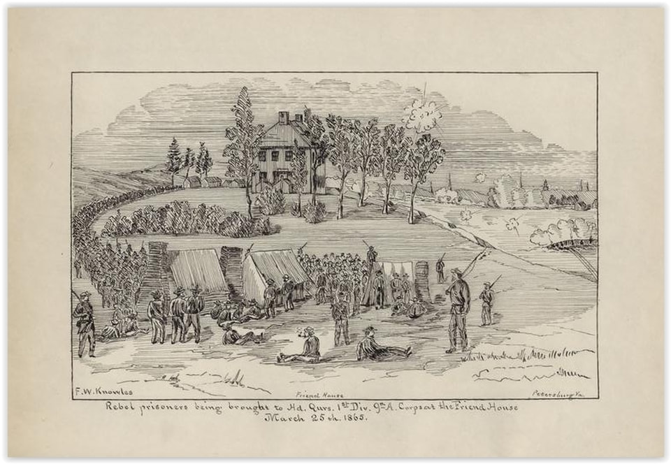
"Rebel prisoners being brought to Hd. Qtrs. 1st Div. 9th A. Corps at the Friend House, March 25th, 1865". Francis W. Knowles Papers, #164, East Carolina Manuscript Collection..
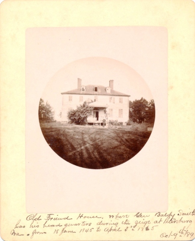
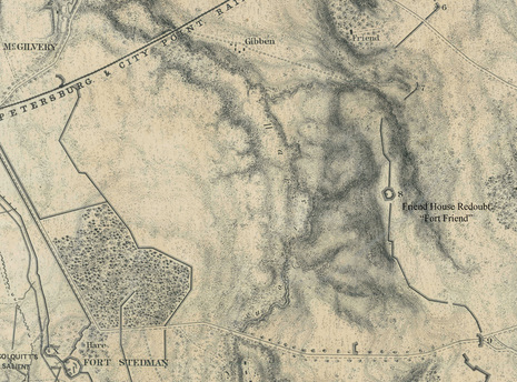
Photograph in the collection at Petersburg National Battlefield, photographer and date unknown, taken from near the Gibbens compound looking east.
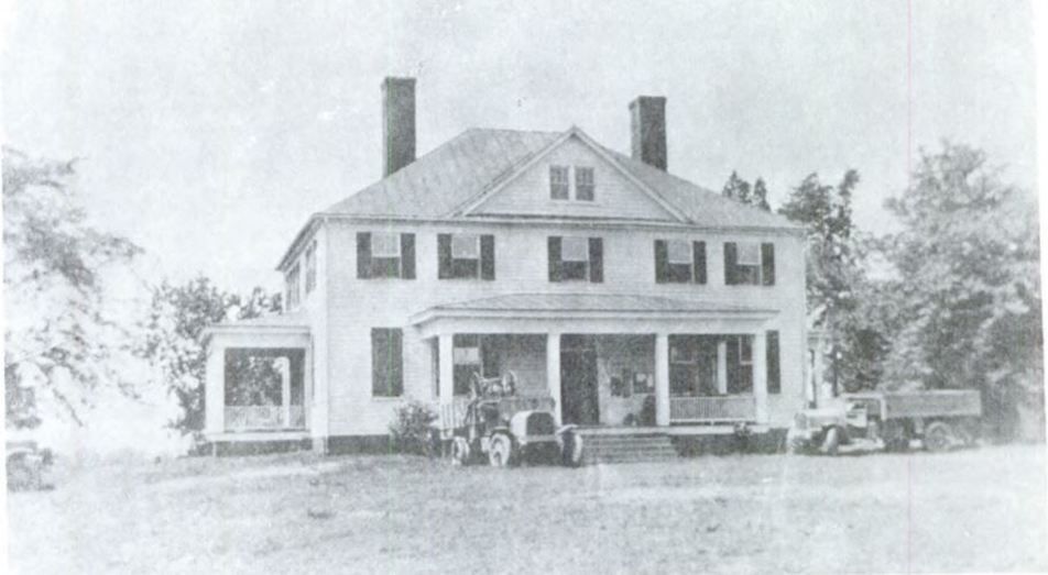
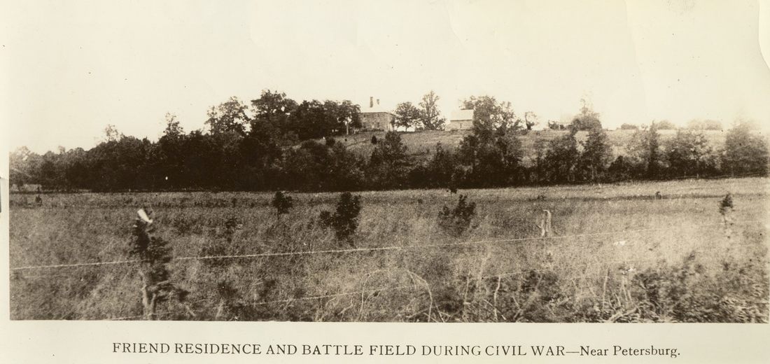
Friend House, c. 1918. Collection of Petersburg National Battlefield.
SEE THIS: View from Friend House toward Gibben complex and Petersburg
Friend House Redoubt
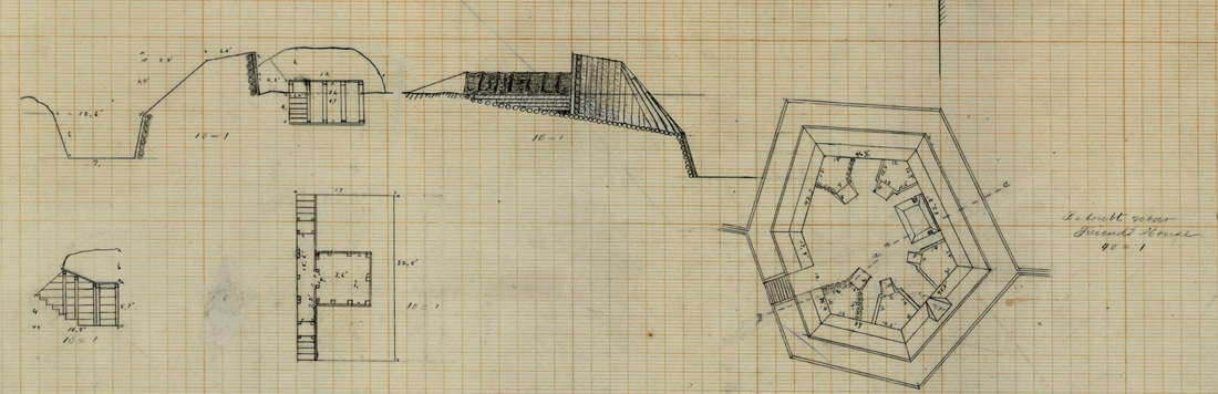
"Redoubt Near Friend's House," Federal engineers plan, NARA RG77 Drawer 150 - Sheet 65 1/2.
“HEADQUARTERS ARMY OF THE POTOMAC, ENGINEER DEPT., November 7, 1864. COLONEL: The following report for the week ending on the 5th instant, exhibiting the engineering operations of the Army of the Potomac during that period, is respectfully submitted for the information of the lieutenant-general commanding the Armies of the United States. … Lieutenant Benyard, assisted by Lieutenant Lydecker, superintended the construction of the redoubts near the Avery house and the Friend house, and the former also directed the countermining at Fort Stedman. The redoubts have both been completed and the listening galleries driven forty feet.” O.R. vol. 40, 1: 176 |
The Friend House Redoubt, originally Battery 8 of the Confederate Dimmock Line, was redesigned and refaced as a back up for the main Federal line. From its perch, high upon the ridge overlooking Harrison's Creek, "Fort Friend" delivered a telling fire when a surprise Confederate assault overran Fort Stedman half a mile to the west at dawn of March 25, 1865. The system of enclosed forts, crossing artillery fires, and supporting works worked exactly as it was meant to work. The breakthrough was minimized, then contained, and the enemy's advance delayed until mobile reserves could be organized to counterattack.
“Captain Jones, of the Eleventh Massachusetts Battery, occupying Fort Friend, with six 3-inch rifle pieces, promptly manned his guns upon the first alarm, and about half an hour afterward was enabled, by the dawning of day, to distinguish the before-mentioned body of the enemy moving from Fort Stedman toward Fort Haskell. He immediately opened fire upon them; at the same time lie discovered a line of skirmishers advancing toward the hill upon which his fort is situated, and as the hue of skirmishers arrived at the ravine in front of the fort, discharged canister into them, which had the effect of checking their advance until the regiment of Pennsylvania troops, encamped near the fort, formed, advanced, and drove back the line. From this commanding position Captain Jones continued to direct a most destructive fire into and around Fort Stedman upon any body of the enemy which made its appearance.” O.R. vol. 46, 1: 357. |
Friend House Accounts
Livermore, Days and Events, page 372.
"General Smith's headquarters were at the Friend house, which stood on a bold promontory which projected into the valley and was within a long musket-shot of the enemy's line; at least that seems to me a fair measurement, as a bullet struck in our tent one evening when we were at tea, and of course we were in easy range for the enemy's cannon. Our tents were arranged in three sides of a parallelogram behind the house, and it, one of the pretentious square mansions of Virginia, formed the fourth side of the square and hid our tents from view of the enemy. But the outlying tents, which covered our stores, servants, and guards, were in view, and the constant arrival and departure of generals, staff officers, and or derlies told plainly enough what was behind the house, but strange to say for a long time we were unmolested by artillery, and the only reason we ever heard was that the owner of the house was the commander of the battery which had the best range of us."
"General Smith's headquarters were at the Friend house, which stood on a bold promontory which projected into the valley and was within a long musket-shot of the enemy's line; at least that seems to me a fair measurement, as a bullet struck in our tent one evening when we were at tea, and of course we were in easy range for the enemy's cannon. Our tents were arranged in three sides of a parallelogram behind the house, and it, one of the pretentious square mansions of Virginia, formed the fourth side of the square and hid our tents from view of the enemy. But the outlying tents, which covered our stores, servants, and guards, were in view, and the constant arrival and departure of generals, staff officers, and or derlies told plainly enough what was behind the house, but strange to say for a long time we were unmolested by artillery, and the only reason we ever heard was that the owner of the house was the commander of the battery which had the best range of us."
William R. Driver, "Siege of Petersburg After the Capture of the Weldon Railroad," in Papers of the Military Historical Society of Massachusets, vol. 5 (1906), 312-313
“It seems almost unaccountable that greater damage was not done to some of the houses within range of the enemy's fire and without protection of works. In a residence of more than a month at the Friend house, which was in rear of Fort McGilvery and on the right of the line near the river, situated on a bluff, in range and full view of a part of the enemy's line on both sides of the river, and made prominent by a signal station in constant use on its roof, with a 13-inch mortar in position behind it, the house was not struck once, though the twice daily artillery fire sent missiles all round it. And at the Avery house, a residence of about the same length of time resulted in the same experience, although this house was less prominent. In October the enemy placed in barbette an 8-inch Columbiad directly opposite this house under the cover of darkness, but kept it there only three days, during which it was fired but once or twice. The first shell thrown from it fell directly in the door-yard in front of the house and by a piece of good fortune failed to explode.”
“It seems almost unaccountable that greater damage was not done to some of the houses within range of the enemy's fire and without protection of works. In a residence of more than a month at the Friend house, which was in rear of Fort McGilvery and on the right of the line near the river, situated on a bluff, in range and full view of a part of the enemy's line on both sides of the river, and made prominent by a signal station in constant use on its roof, with a 13-inch mortar in position behind it, the house was not struck once, though the twice daily artillery fire sent missiles all round it. And at the Avery house, a residence of about the same length of time resulted in the same experience, although this house was less prominent. In October the enemy placed in barbette an 8-inch Columbiad directly opposite this house under the cover of darkness, but kept it there only three days, during which it was fired but once or twice. The first shell thrown from it fell directly in the door-yard in front of the house and by a piece of good fortune failed to explode.”
Isaiah Price. A History of the Ninety-Seventh Regiment Pennsylvania Volunteer Infantry .P294-296.
"After the earthworks on the heights had been captured, the 97th P. V. moved to the right, and occupied the heights at Dr. Friend's house, an eminence overlooking the city of Petersburg and the intervening country; two lines of the enemy being in plain view, the next morning, at the foot of the slope. During the night, the reverse face of the hill was intrenched, which occupied the troops until morning. Advance parties were sent forward, during the early part of the night, to ascertain the position of the enemy. They were able to proceed for a considerable distance, encountering only straggling parties, a few of whom were captured. Later in the night, the rebel lines were re-established at a short distance in our front. Before morning, a very different enemy confronted and menaced the advance upon Petersburg. The van of Lee's veterans was now before us. By their arrival, the fall of Petersburg, so imminent and so possible the evening before, was now indefinitely postponed.
Early on the morning of the 16th, a line of skirmishers with strong support, dashed rapidly forward, from Gen. Smith's lines, near Friend's house, to intercept and capture a rebel force, occupy ing a position behind some buildings on the banks of Harrison's creek, three hundred yards distant. They were met by a severe fire from the enemy which caused the line to waver. Seeing the peril of the situation and the need of encouragement, the boys of the 97th P. V. arose in the trenches and sent forth hearty cheers. The line then dashed forward again and carried the position, capturing over two hundred prisoners. The batteries at Friend's house had, by a well-directed fire, routed this force from the adjacent trenches, to seek concealment behind the bank and the buildings (294-295).
[June 18, 1864] A heavy advance picket was thrown for ward to drive the rebel pickets from their position in front of Friend's house, on the old race course, near Petersburg, from which quarter an attack by the enemy was anticipated. Capt. W. S. Mendenhall was in command of the detail from the 3d brigade, consisting of Companies D and G of the 97th P. V., and other companies of the brigade, in all about three hundred men. They advanced and drove the enemy from their rifle pits in the cornfield, and occupied the entire valley. This force was subjected to a heavy fire during most of the day. The men found shelter in pits dug with their bayonets, taking advantage of every favorable point in the ground. Capt. Mendenhall's force was relieved, later in the evening, by a detail from the 6th Corps, when he was directed by an aid-de-camp to report at Friend's house for instructions."
S. Millett Thompson, The 13th New Hampshire Regiment, 424.
"July 1, [1864]. Fri. Hot, dusty. Regt. In front rifle-trenches on the river. The Band of the 2d Brig. 1st DIv. 18th Army Corps, and formerly of the 13th is now at Gen. Smith's 18th Army Corps Hdqrs. at the Charles
Friend mansion on Friend's Hill. The 2nd N. H. at these Hdqrs. President Lincoln has visited here, and made a long survey of the lines of the rebel army from this hill."
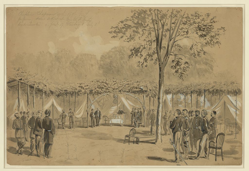
LC ppmsca 21697. William Waud.
Chaplain Chapman of the 169th N.Y. performing divine service at Gen. W.F. Smith's Head Quarters in front of Petersburg, July 3rd.
Inscribed below image with arrow indicators: Gen Burnham; Gen Neil; Gen Smith; Gen Martindale.
- Inscribed on verso: The Service was arranged by Dr Luckley, Medical Director of the 18th Army Corps.
- Published in: Harper's Weekly, July 23, 1864, 468.
Cellar of Friend House today.
