The Petersburg Project
  • Home
    • About Us
  • Blog and Updates
  • Civil War Combat Trenching
  • Views of the City of Petersburg
    • Petersburg Panorama 1865
    • Steeples of Petersburg
    • Petersburg Mill Photographs
  • The Mine Explosion and its Crater
  • Petersburg in Pencil and Ink
    • Alfred R. Waud, Special Artist at Petersburg >
      • Waud Drawing of 5th Corps Fortifications
    • William Waud, Special Artist
    • Charles H. Chapin, Special Artist
    • Joseph Becker, Special Artist at Petersburg
    • Edwin Forbes, Special Artist at Petersburg
    • Winslow Homer, Special Artist
    • Edward Mullen, Special Artist at Petersburg
    • Andrew W. Warren, Special Artist
    • Enlisted Artists >
      • Charles Wellington Reed
      • Andrew McCallum
      • Francis Knowles
      • James William Pattison
      • Herbert Valentine
      • Howard A. Camp
  • Petersburg Photographs --So Many!
    • Dimmock Battery 5 Photographs >
      • Working with Photographs
    • City Point
    • City Point Wharf Explosion, Aug. 9, 1864
    • Fort Rice?? We don't think so!
    • Federal Picket Line, Jerusalem Plank Road
    • Egbert Guy Fowx, Photographer at Petersburg
    • Timothy O'Sullivan, Photographer at Petersburg >
      • Harrison's Creek USCT Camps
      • Fort Morton and Baxter Road Group
      • Fort Haskell Panorama and Bomb Proofs
      • Fort Stedman Group
      • Gracie's Salient Group
      • Camp of the 50th N. Y. Engineers
    • David Knox, Photographer at Petersburg
    • William Redish Pywell, Photographer at Petersburg
    • John Reekie, Photographer at Petersburg
    • Thomas C. Roche, Photographer at Petersburg
    • Andrew J. Russell, Photographer at Petersburg >
      • "Fort Mahone" CS Batteries 25 & 27
  • U. S. Military Railroad
    • Terminus of Military R. R. at City Point
    • City Point to Clark's Station
    • Pitkin's Station to Shooting Hill
    • Hancock's Junction/Jerusalem Plank Road
    • Parke's Station
    • Warren's Station
    • Patrick's Station
  • Topographical Engineers -- Our Heroes
    • Grand Medicine Pow-wow
    • Michler's Reports from Topographical Department
    • John E. Weyss, Cartographer
    • William H. Paine, Cartographer
    • Gilbert Thompson
    • Albert Hanry Campbell, C.S.A. Cartographer
  • Confederate Maps
    • Confederate Defenses 1862
    • Gilmer-Campbell Maps, 1864
    • Stevens Map July 1864
    • Fields of Fire
    • Campbell Dinwiddie County 1864
    • Coit's map of the Crater Battlefield
  • Federal Maps
    • Army of the Potomac, Routes of the Corps to Petersburg
    • June 9 1864, Kautz Attack
    • June 18, 1864-Federal Engineers Maps
    • June 18, 1864, 18th Corps
    • June 19, 1864, Engineers Map
    • June 21, 1864, Federal Engineers Maps
    • June 22, 1864. Second Corps at Jerusalem Plank Road
    • June 29, 1864. Dept of VA and NC
    • June 30, 1864 -- XVIII Corps Map
    • June-July, Undated Federal Engineers Map-
    • July 29, 1864, Engineers Map, Annotated
    • July 1864 Map of XVIII Corps Lines
    • Crater, Native American Perspective of the Crater
    • August 1864, Michie Map - Bermuda 100
    • August 28, 1864, Michler Map
    • Aug.-Nov. 1864 Two Base Maps
    • September 13, 1864, Recon Map
    • Sept. 13-Oct.25 versions. Redoubts and Batteries
    • September 30, 1864, Warren Map
    • October 1864, Two IX Corps Maps
    • October 20, 1864. Benham's map of defenses of City Point
    • Nov. 2, 1864, Army of the Potomac
    • 1864, Coast Survey Map of Petersburg
    • Michler Map Series 1865-1867
    • 1864-1867, Michler-Weyss, Siege of Petersburg
    • 1865-1867, Manuscript Survey Maps
    • 1871, Map of Recapture of Ft. Stedman
    • 1881, Boydton Plank Road
  • Confederate Forts and Batteries
    • Dimmock Line >
      • Priest Cap
      • French Rifle Pits
    • Fort Clifton
    • "Fort Mahone" CS Batteries 25 & 27
    • Confederate 8-inch Columbiad
    • Leadworks
  • Federal Forts and Batteries
    • Union Battery Ten (X)
    • Fort Alexander Hayes
    • Fort Avery
    • Fort Conahey
    • Fort Davis & Battery XXII
    • Fort Fisher
    • Fort Meikel --Photographic Views
    • Fort Morton
    • Fort Patrick Kelly
    • Fort Sedgwick, better known as Fort Hell,
    • Fort Wadsworth -- the Evolution
    • Fort Willcox or Battery XVI
  • Battlefield Features
    • Aiken House
    • Armstrong's Mill
    • Avery House
    • Bailey/Johnston Farm
    • Blandford Church
    • Broadway Landing, Appomattox River
    • The Crater
    • Cummings House
    • Dams and Inundations
    • WW Davis Farm
    • Dunn House
    • Friend House >
      • View from Friend House toward Gibben complex and Petersburg
    • Gibbons Properties
    • Globe Tavern / Weldon Railroad
    • Gregory House
    • Griffith Farm
    • Gurley House
    • Hare House Hill
    • The "Horseshoe"
    • Jerusalem Plank Road
    • Jones House
    • Jordan House
    • Newmarket Racecourse
    • Pegram's Farm
    • Peebles Farm, Pegrams Farm, Poplar Springs Church
    • Shands House
    • Taylor Farm >
      • The Ice House
      • Surviving Taylor Barn
    • Williams House
  • Signal Towers and Trees
    • Some Operations of the Signal Corps at Petersburg
  • Archeology
    • Geology of the Crater
    • Fieldwork -- Petersburg
    • Civil War Sinks
    • Deserted Confederate Camp
    • Gracie's Countermine
    • LIDAR Forts and Batteries
  • Articles, Papers, Presentations
    • Shiman: A Note on Maps
    • The Siege Landscape: Through Fire and Ice at Petersburg
    • "The Rebel in the Road"
    • "A Strange Sort of Warfare Underground"
    • Lost Trenches of Petersburg: June 17
    • Between the Lines
    • Combat Trenching: An Introduction
    • Lowe -- Post-War Topographical Survey
    • Civil War Maps and Landscapes -- Observations
  • Kittens, Puppies & Ponies
  • Executions!
  • Notes on Leveled Earthworks
  • Depot Hospital at City Point
  • Pontoon Bridges
  • The Great Pontoon Bridge Across James River
  • Captain Robert Davis CSA

Harrison's Creek USCT Camps

These five images of camps and bomb proofs appear to us to have been taken behind the protective bluff along Harrison's Creek in early-to-mid-August,1864, near Park Tour Stop 4. Timothy O'Sullivan was a stringer for Gardner's studio at the time and was working with photographer David Knox, who appears in two of the images as a human copyright. These images were colorized with Photoshop to bring out contrasts and details {with no artistic pretensions). In Grant and Lee: The Virginia Campaigns 1864-1865 (282-285), William Frassanito discussed these images in some detail and came to a different, although provisional, conclusion. Frassanito suggested these images were taken at the Baxter Road crossing of Poor Creek, placing the location east of the Crater. This was based on his interpretation of negative numbers 801-810, the inclusion of Ferrero's image in this group, and the location of Ferrero's division in the Ninth Corps sector in early August. Frassanito did acknowledge "that other black troops, members of the Eighteenth Corps of Butler's Army of the James, were also stationed on the Petersburg front at the same time, albeit in another sector located to the north of the Ninth Corps positions." Frassanito admitted that it would be difficult to confirm whether the USCTs in these images "were Ferrero's men."

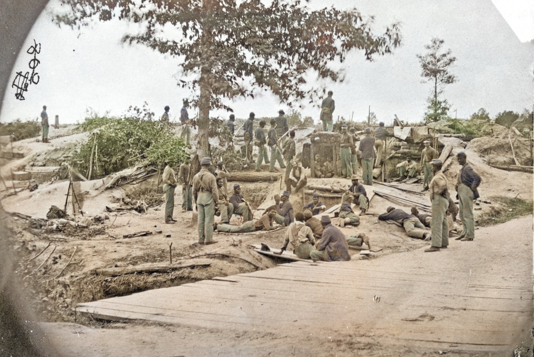
Our identification of the Harrison's Creek location is based on several factors. The terrain of the Baxter Road crossing of Poor Creek nowhere matches the location of these photos. There the east bank (rear) is high and the west bank (to the front) is low and swampy for 100 yards before rising in a very abrupt bluff. Importantly, in our assessment, nothing could travel along this segment of Baxter Road in early August 1864 as it was under fire from Elliott's Salient. The only way to reach the bridge safely would be to carry the heavy cameras (along with fragile, quickly expiring, prepared photographic plates) through a maze of covered ways that led to the front from the vicinity of Fort Morton. ​To peer over the bluff (as do some of the soldiers in these images) at this point would invite a sharpshooter's bullet to the forehead. Harrison's Creek, on the other hand, was 500 yards behind the front line at the collection of earthworks that would soon-to-be Fort Stedman. The Court House Road crossed the creek safely here. The length of the bridge shown in the images would span Harrison's Creek today. A farm road leading to the Gibbon house ran parallel to the creek and could have been used by O'Sullivan and crew to get views upstream and downstream. It is a safe bet that the photography wagon was parked nearby. This location was directly behind Duncan's sector.

According to The Union Army 1861-1865: Organization and Operations, vol. 1, pg.482: the 18th Corps occupied the right flank of the Petersburg lines after August 3rd. Duncan's Brigade consisting of 4th and 6th USCTs with 10th USCT attached, was ordered into the Petersburg lines on August 3rd and stayed until August 16. Then 4th and 6th USCTs were sent to Dutch Gap. Night of August 14-15, 18th Corps extended left to replace 5th Corps and held the line from the River to near the Crater. 

Reference in the O.R. vol. 42 pt 2, 38:

HDQRS. THIRD DIV., 18TH ARMY CORPS,
Near Petersburg, Va., August 3, 1864.
*          *          *          *          *          *          *          *          *          *
4. Colonel Duncan will march with and in command of the Fourth, Sixth, and Twenty-second Regiments across the Appomattox River, encamping his own regiment and Colonel Ames' near the present camp of the Tenth U.S. Colored Troops, and Colonel Kiddoo's move to the left and to the rear. Colonel Duncan will be charged with the defense of the line in case of an attack to the left of Battery 8, posting no picket, however, except as now posted by the colored troops now on that line. <ar88_38>

--That puts them in the neighborhood.

USCTs were deployed in the vicinity of Harrison's Creek during and after the first week of August 1864, holding the front line south of Battery 8 to near Fort Stedman. Some soldiers of the 10th USCT may be portrayed in these images.​ From sketchy reports, it appears that Ferrero's troops had been split up, and possibly moved west from the Baxter Road sector.

Picture
CDV of Samuel Augusts Duncan of 14th New Jersey. Infantry, appointed colonel of the 4th USCTs, commanding a brigade of USCTs in Hinks' Division.
Picture
CDV of Brig. Gen. Edward Winslow Hinks from Massachusetts was a career military officer who headed a division of USCTs in the Eighteenth Army Corps of the Army of the James.

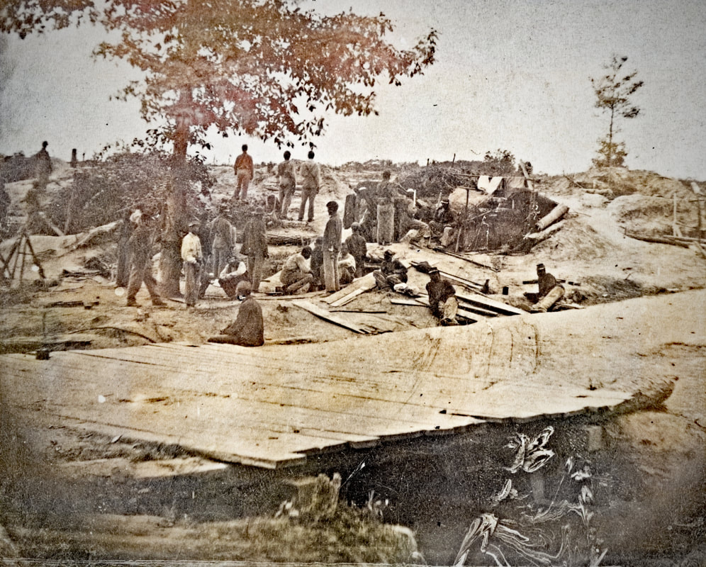
The Photographs are arranged in a possible sequence. When the photographers first arrived few soldiers are about, then things become more crowded and posed, as other soldiers arrived and realized they are being photographed. The camera is shifted to capture closer views of these soldiers. The first photo shows negative number 803, but an earlier number 169? is scratched out. Not all of the original negatives have survived.

Picture
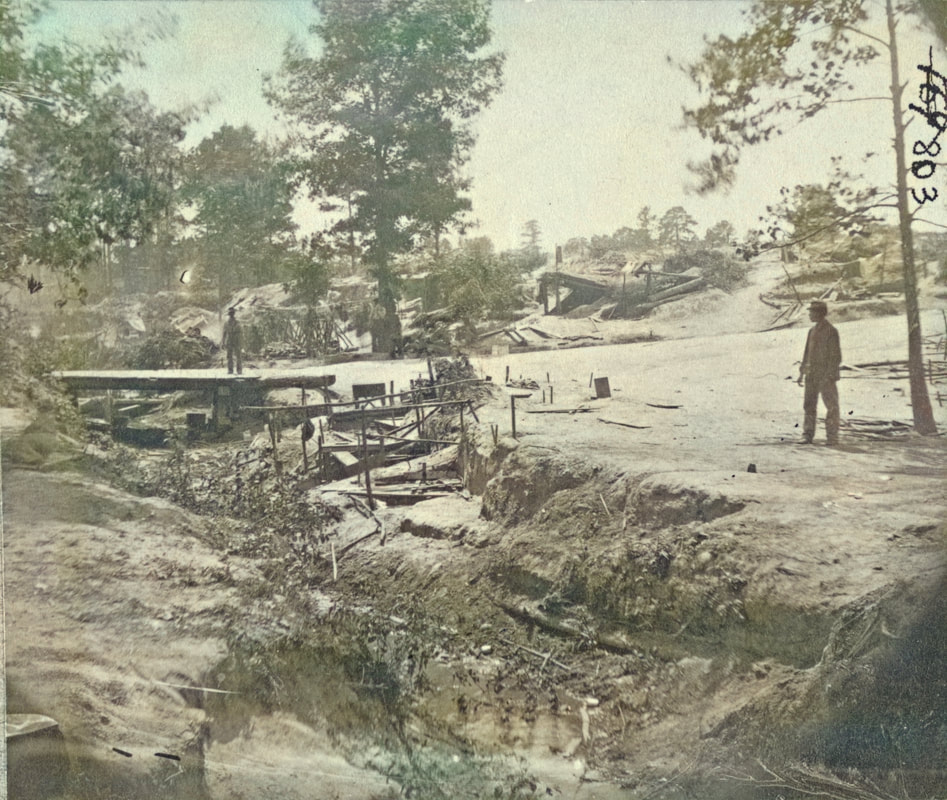
LC32403. [View of bombproof tents . occupied by U.S. colored troops in front of Petersburg, Va., August 7, 1864], Timothy O'Sullivan, photographer. Harrison's Creek is in the foreground. [Photos were colorized to bring out contrasting details.]
Picture
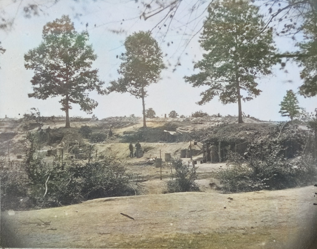
LC32406. [Bombproof kitchen and tents on front line in front of Petersburg, August 10, 1864], Timothy O'Sullivan, photographer. The creek is in the foreground beyond the road, traced by the line of brush.
Picture
LC01232-01233 combined image, colorized. Petersburg, Virginia. [Near view of bombproofs in the advance line], stereo view by Timothy O'Sullivan, dated August 7, 1864. Image was colorized in Photoshop to bring out details. Original image is linked. Scratched out negative number here is 172.
Picture
LC32404. [Part of Federal Line of Works showing bombproof tents occupied by U.S. Colored Troops in front of Petersburg, Va., Aug. 7, 1864], Timothy O'Sullivan, photographer.
Picture
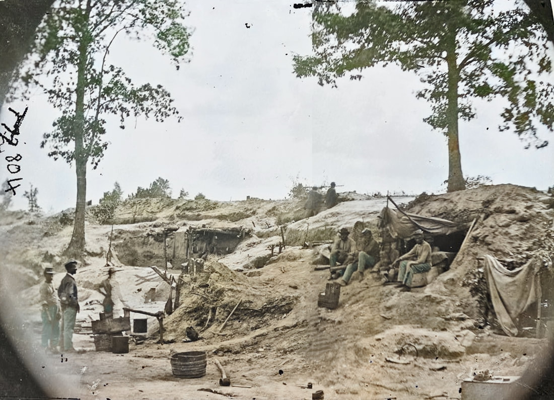
LC32443 left half of stereo image. [Part of Federal Line of Works showing bombproof tents occupied by U.S. Colored Troops in front of Petersburg, Va., Aug. 7, 1864]. photograph by Timothy O'Sullivan. Officer posed with six soldiers presenting bayonets to the enemy. David Knox posed at center of the group in white shirt and vest. Scratched out negative numbers here are 170 and 809.
Picture
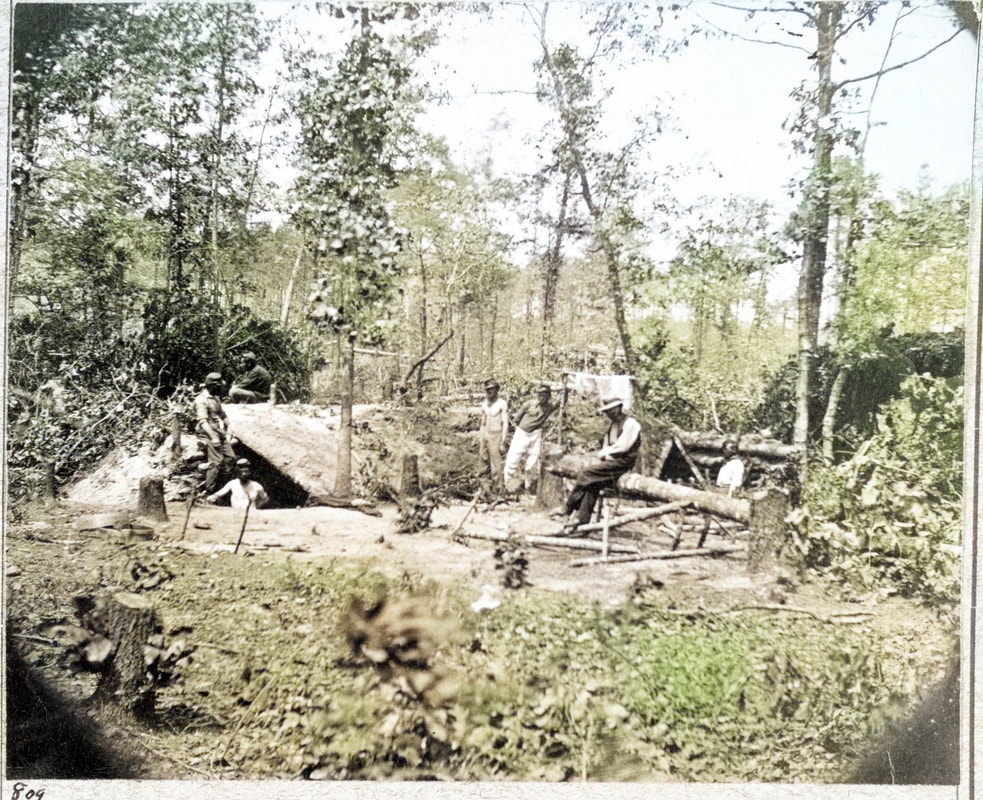
LC32407 print colorized. [A bombproof shelter for the soldiers during the siege of Petersburg, August 10, 1864], negative by Timothy O'Sullivan.Taken in a different location and dated three days after the above series. Rare to have exact dates attached to the photos. No. 809 in the lower left corner of the mount. Looks like Knox seated on the log in right mid-ground.
Picture
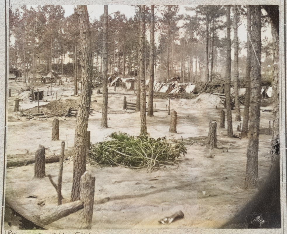
LC32408 print of right plate of stereo view. [Camp of Union soldiers on the line in front of Petersburg, Va., August 10, 1864], negative by Timothy O'Sullivan. No. 810 written n mount. Location unknown but pine woods are evocative of the area behind Fort Haskell.
Picture
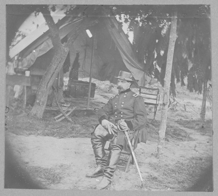
LC35246. [Gen. Edward Ferrero in front of Petersburg, Va., Aug. 1864], unattributed print of a half stereo plate. No negative number visible on this print, but this is likely the image referenced by Frassanito as 807. "Ferrero seated on a stool at his field headquarters."
Picture
Proudly powered by Weebly