The Petersburg Project
  • Home
    • About Us
  • Blog and Updates
  • Petersburg Panorama 1865
  • Steeples of Petersburg
  • The Mine Explosion and its Crater
  • Petersburg in Pencil and Ink
    • Alfred R. Waud, Special Artist at Petersburg >
      • Waud Drawing of 5th Corps Fortifications
    • William Waud, Special Artist
    • Charles H. Chapin, Special Artist
    • Joseph Becker, Special Artist at Petersburg
    • Edwin Forbes, Special Artist at Petersburg
    • Winslow Homer, Special Artist
    • Edward Mullen, Special Artist at Petersburg
    • Andrew W. Warren, Special Artist
    • Enlisted Artists >
      • Charles Wellington Reed
      • Andrew McCallum
      • Francis Knowles
      • James William Pattison
      • Herbert Valentine
      • Howard A. Camp
  • Petersburg Photographs --So Many!
    • Working with Photographs
    • City Point
    • City Point Wharf Explosion, Aug. 9, 1864
    • Fort Rice?? We don't think so!
    • Federal Picket Line, Jerusalem Plank Road
    • Egbert Guy Fowx, Photographer at Petersburg
    • Timothy O'Sullivan, Photographer at Petersburg >
      • Fort Morton and Baxter Road Group
      • Fort Haskell Panorama
      • Fort Stedman Group
      • Gracie's Salient Group
      • Bombproofs behind Fort Haskell
      • Camp of the 50th N. Y. Engineers
    • David Knox, Photographer at Petersburg
    • William Redish Pywell, Photographer at Petersburg
    • John Reekie, Photographer at Petersburg
    • Thomas C. Roche, Photographer at Petersburg
    • Andrew J. Russell, Photographer at Petersburg >
      • "Fort Mahone" CS Batteries 25 & 27
  • U. S. Military Railroad
    • Terminus of Military R. R. at City Point
    • City Point to Clark's Station
    • Pitkin's Station to Shooting Hill
    • Hancock's Junction/Jerusalem Plank Road
    • Parke's Station
    • Warren's Station
    • Patrick's Station
  • Maps and Topogs
    • Grand Medicine Pow-wow
    • Michler's Reports from Topographical Department
    • John E. Weyss, Cartographer
    • William H. Paine, Cartographer
    • Gilbert Thompson
  • Confederate Maps
    • Confederate Defenses 1862
    • Gilmer-Campbell Maps, 1864
    • Stevens Map July 1864
    • Fields of Fire
    • Campbell Dinwiddie County 1864
    • Coit's map of the Crater Battlefield
  • Federal Maps
    • Army of the Potomac, Routes of the Corps to Petersburg
    • June 18, 1864-Federal Engineers Map
    • June 18, 1864, 18th Corps
    • June 21, 1864, Federal Engineers Map
    • June 22, 1864. Second Corps at Jerusalem Plank Road
    • June 29, 1864. Bermuda Hundred
    • June 30, 1864 -- XVIII Corps Map
    • June-July, Undated Federal Engineers Map-
    • July 1864 Map of XVIII Corps Lines
    • Crater, Native American Perspective of the Crater
    • August 28, 1864, Michler Map
    • September 13, 1864, Recon Map
    • September 30, 1864, Warren Map
    • October 1864, Two IX Corps Maps
    • Nov. 2, 1864, Army of the Potomac
    • 1864, Coast Survey Map of Petersburg
    • NEW 1865-1867, Manuscript Survey Maps
    • 1864-1867, Michler-Weyss, Siege of Petersburg
    • 1865-1867, Michler Map Series
    • 1871, Map of Recapture of Ft. Stedman
    • 1881, Boydton Plank Road
  • Confederate Forts and Batteries
    • Dimmock Line >
      • Priest Cap
      • French Rifle Pits
    • Fort Clifton
    • "Fort Mahone" CS Batteries 25 & 27
    • Confederate 8-inch Columbiad
    • Leadworks
  • Federal Forts and Batteries
    • Battery X
    • Fort Alexander Hayes
    • Fort Avery
    • Fort Conahey
    • Fort Davis & Battery XXII
    • Fort Fisher
    • Fort Meikel --Photographic Views
    • Fort Morton
    • Fort Patrick Kelly
    • Fort Sedgwick, better known as Fort Hell,
    • Fort Wadsworth -- the Evolution
    • Fort Willcox or Battery XVI
  • Battlefield Features
    • Aiken House
    • Armstrong's Mill
    • Avery House
    • Bailey/Johnston Farm
    • Blandford Church
    • Broadway Landing, Appomattox River
    • The Crater
    • Cummings House
    • Dams and Inundations
    • WW Davis Farm
    • Dunn House
    • Friend House >
      • View from Friend House toward Gibben complex and Petersburg
    • Gibbons Properties
    • Globe Tavern / Weldon Railroad
    • Gregory House
    • Griffith Farm
    • Gurley House
    • Hare House
    • Hare House Hill
    • The "Horseshoe"
    • Jerusalem Plank Road
    • Jones House
    • Jordan House
    • Newmarket Racecourse
    • Pegram's Farm
    • Peebles Farm, Pegrams Farm, Poplar Springs Church
    • Shands House
    • Taylor Farm >
      • The Ice House
      • Surviving Taylor Barn
    • Williams House
  • Signal Towers and Trees
    • Some Operations of the Signal Corps at Petersburg
  • Archeology
    • Geology of the Crater
    • Fieldwork -- Petersburg
    • Civil War Sinks
    • Deserted Confederate Camp
    • Gracie's Countermine
    • LIDAR Forts and Batteries
  • Articles, Papers, Presentations
    • Shiman: A Note on Maps
    • The Siege Landscape: Through Fire and Ice at Petersburg
    • "The Rebel in the Road"
    • "A Strange Sort of Warfare Underground"
    • Lost Trenches of Petersburg: June 17
    • Between the Lines
    • Combat Trenching: An Introduction
    • Lowe -- Post-War Topographical Survey
    • Civil War Maps and Landscapes -- Observations
  • Kittens, Puppies & Ponies
  • Executions!
  • Notes on Leveled Earthworks
  • Civil War Combat Trenching
  • Depot Hospital at City Point
  • Dimmock Battery 5 Photographs
  • Pontoon Bridges
  • The Great Pontoon Bridge Across James River
  • Appomattox Mill Photographs
  • Blank Page

Headquarters, Army of the Potomac, during the Petersburg Campaign.

Douthat's House, Weyanoke Plantation, June 15, 1864
The Petersburg Offensive began in earnest with the construction of a grand pontoon bridge across James River over which much of the Army of the Potomac crossed.  On Wednesday,June 15, MEADE and his entourage reached the north bank of the river and established Headquarters near Douthart's House, the seat of Weyanoke Plantation. According to Lyman (Meade's Army, 204-205), "The General rode to Douthart's--a brick house large and grand, standing at the point of a well-tilled peninsula which is enclosed by a bend of the river. The General in a sharp humor, though things seemed moving well enough."
Picture
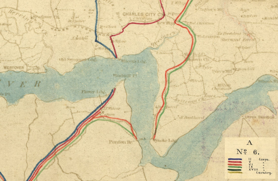
LC cw050100 detail from "[Map of the lines of march of the Army of the Potomac from Culpeper to Petersburg, Virginia," Army of the Potomac, Engineer Department, showing area where the Great Pontoon was laid at "Wynoke Ldg." Second and part of Fifth Army Corps converged on Wilcox's Landing and crossed the river on steamers to Windmill Point. Sixth and Ninth Corps and the army trains crossed the pontoons. The bridge was dismantled entirely on June 18.

Picture
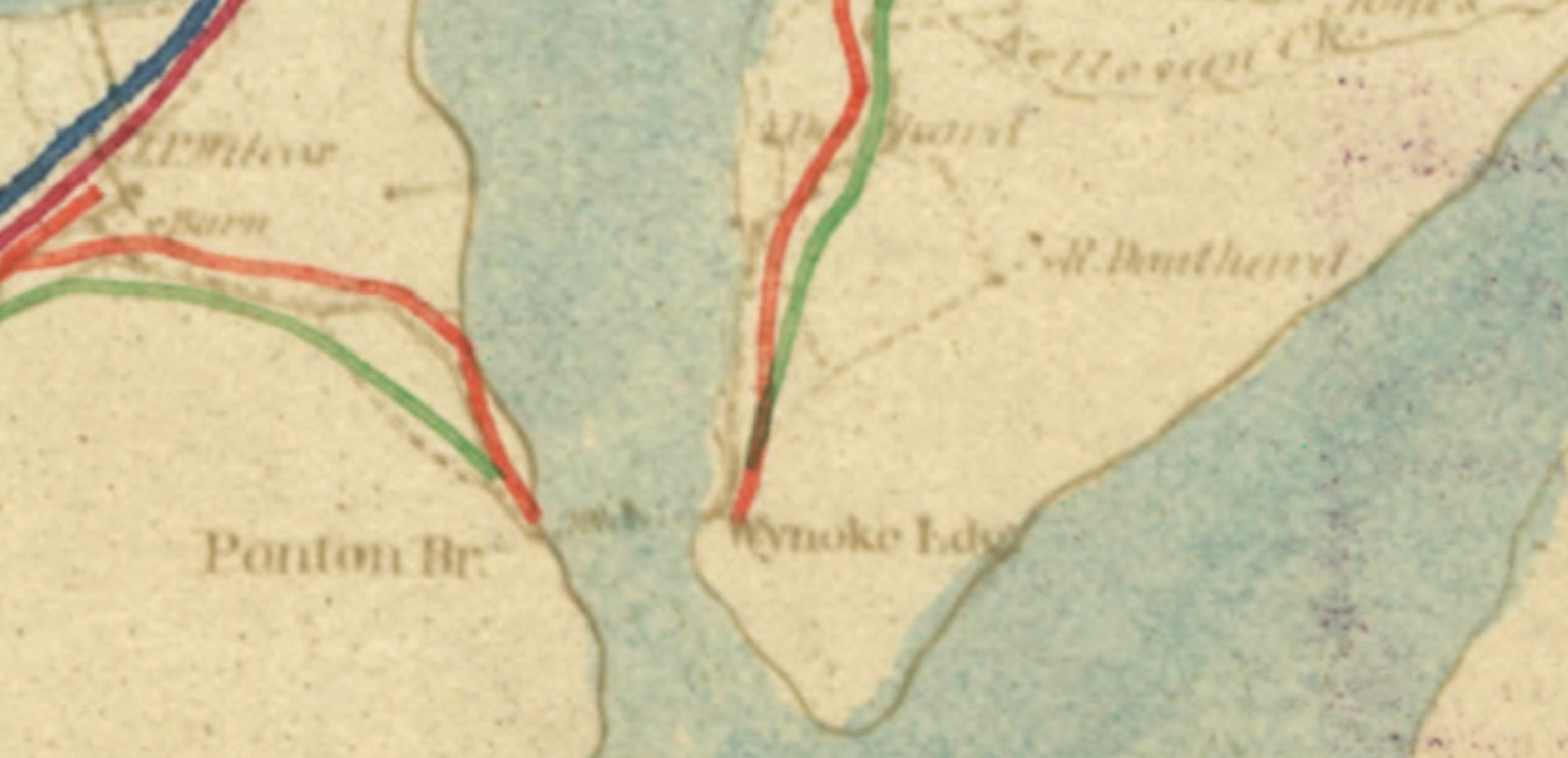
Detail from the above map, showing the site of the Pontoon Bridge at Wyanoke Landing. Above and to the right, a house is labeled "R. Douthard." This was the home of Robert Douthat, on the north bank of James River, where General Meade made his headquarters during the night of June 15th. From here he observed the completion of the bridge.
Picture
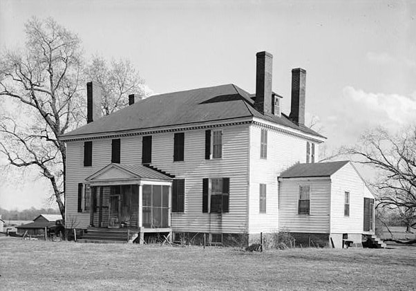
Weyanoke Plantation Main House. Photo from HABS/HAER documentation. At the time of the Civil War the property was owned by Robert Douthat (spelled Douthard or Douthart on some maps).
The bridge extended from Weyanoke Plantation, Charles City County, on the north bank to Flowerdew Hundred Plantation, Prince George County, on the southside. Extensive archeological examination has been conducted at Flowerdew Plantation over the years.The original house was demolished.
Near the Bailey House, June 16
During the day of June 16th, MEADE crossed the pontoon bridge and rode to the front where there had been heavy fighting by Smith's Corps, who captured a half-mile of the formidable Dimmock Line that defended Petersburg. Hancock's Second Corps had moved into position and was pressing the attack Lyman was sent out to find a spot for headquarters (Meade's Army, 207). "Sent to establish our Headq'rs--a difficult matter for things are as dry as bone dust. Found Bailey's house all smashed inside and used as a hospital, about 50 or 40 wounded there, from the skirmish line. Put our Headq'rs in the field below the house."
Picture
Detail of Map 20, Army of the Potomac Engineers, showing Bailey house on the City Point Road to the upper right. NARA RG77 G211-20
Picture
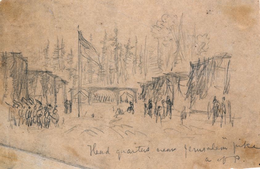
LC . "Headquarters near Jerusalem Plank Road, A of P," sketch by Alfred Waud.
Picture
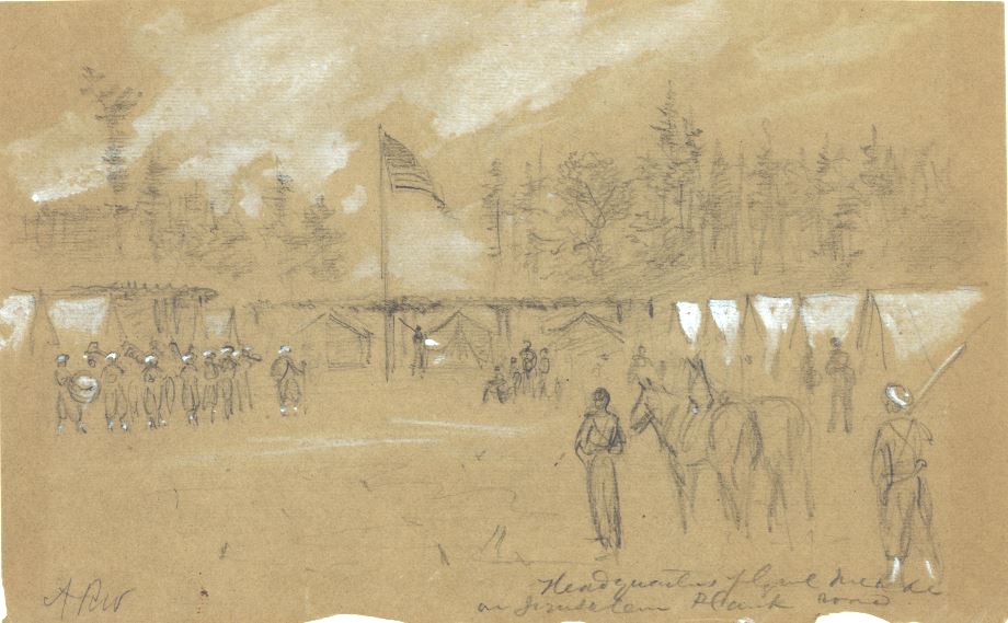
LC 21547, A. R. Waud. Headquarters Genl Meade at Jerusalem Plank Road.
Proudly powered by Weebly
Picture