The Petersburg Project
  • Home
    • About Us
  • Blog and Updates
  • Petersburg Panorama 1865
  • Steeples of Petersburg
  • The Mine Explosion and its Crater
  • Petersburg in Pencil and Ink
    • Alfred R. Waud, Special Artist at Petersburg >
      • Waud Drawing of 5th Corps Fortifications
    • William Waud, Special Artist
    • Charles H. Chapin, Special Artist
    • Joseph Becker, Special Artist at Petersburg
    • Edwin Forbes, Special Artist at Petersburg
    • Winslow Homer, Special Artist
    • Edward Mullen, Special Artist at Petersburg
    • Andrew W. Warren, Special Artist
    • Enlisted Artists >
      • Charles Wellington Reed
      • Andrew McCallum
      • Francis Knowles
      • James William Pattison
      • Herbert Valentine
      • Howard A. Camp
  • Petersburg Photographs --So Many!
    • Working with Photographs
    • City Point
    • City Point Wharf Explosion, Aug. 9, 1864
    • Fort Rice?? We don't think so!
    • Federal Picket Line, Jerusalem Plank Road
    • Egbert Guy Fowx, Photographer at Petersburg
    • Timothy O'Sullivan, Photographer at Petersburg >
      • Fort Morton and Baxter Road Group
      • Fort Haskell Panorama
      • Fort Stedman Group
      • Gracie's Salient Group
      • Bombproofs behind Fort Haskell
      • Camp of the 50th N. Y. Engineers
    • David Knox, Photographer at Petersburg
    • William Redish Powell, Photographer at Petersburg
    • John Reekie, Photographer at Petersburg
    • Thomas C. Roche, Photographer at Petersburg
    • Andrew J. Russell, Photographer at Petersburg >
      • "Fort Mahone" CS Batteries 25 & 27
  • U. S. Military Railroad
    • Terminus of Military R. R. at City Point
    • City Point to Clark's Station
    • Pitkin's Station to Shooting Hill
    • Hancock's Junction/Jerusalem Plank Road
    • Parke's Station
    • Warren's Station
    • Patrick's Station
  • Maps and Topogs
    • Grand Medicine Pow-wow
    • Michler's Reports from Topographical Department
    • John E. Weyss, Cartographer
    • William H. Paine, Cartographer
    • Gilbert Thompson
  • Confederate Maps
    • Confederate Defenses 1862
    • Gilmer-Campbell Maps, 1864
    • Stevens Map July 1864
    • Fields of Fire
    • Coit's map of the Crater Battlefield
  • Federal Maps
    • Army of the Potomac, Routes of the Corps to Petersburg
    • June 18, 1864-Federal Engineers Map
    • June 18, 1864, 18th Corps
    • June 21, 1864, Federal Engineers Map
    • June 22, 1864. Second Corps at Jerusalem Plank Road
    • June 30, 1864 -- XVIII Corps Map
    • June-July, Undated Federal Engineers Map-
    • July 1864 Map of XVIII Corps Lines
    • Crater, Native American Perspective of the Crater
    • August 28, 1864, Michler Map
    • September 30, 1864, Warren Map
    • October 1864, Two IX Corps Maps
    • Nov. 2, 1864, Army of the Potomac
    • 1864, Coast Survey Map of Petersburg
    • NEW 1865-1867, Manuscript Survey Maps
    • 1864-1867, Michler-Weyss, Siege of Petersburg
    • 1865-1867, Michler Map Series
    • 1871, Map of Recapture of Ft. Stedman
    • 1881, Boydton Plank Road
  • Confederate Forts and Batteries
    • Dimmock Line >
      • Priest Cap
      • French Rifle Pits
    • Fort Clifton
    • "Fort Mahone" CS Batteries 25 & 27
    • Confederate 8-inch Columbiad
    • Leadworks
  • Federal Forts and Batteries
    • Battery X
    • Fort Alexander Hayes
    • Fort Avery
    • Fort Conahey
    • Fort Davis & Battery XXII
    • Fort Fisher
    • Fort Meikel --Photographic Views
    • Fort Morton
    • Fort Patrick Kelly
    • Fort Sedgwick, better known as Fort Hell,
    • Fort Wadsworth -- the Evolution
    • Fort Willcox or Battery XVI
  • Battlefield Features
    • Aiken House
    • Armstrong's Mill
    • Avery House
    • Bailey/Johnston Farm
    • Blandford Church
    • Broadway Landing, Appomattox River
    • The Crater
    • Cummings House
    • Dams and Inundations
    • WW Davis Farm
    • Dunn House
    • Friend House >
      • View from Friend House toward Gibben complex and Petersburg
    • Gibbons Properties
    • Globe Tavern / Weldon Railroad
    • Gregory House
    • Griffith Farm
    • Gurley House
    • Hare House
    • Hare House Hill
    • The "Horseshoe"
    • Jones House
    • Jordan House
    • Newmarket Racecourse
    • Pegram's Farm
    • Peebles Farm, Pegrams Farm, Poplar Springs Church
    • Shands House
    • Taylor Farm >
      • The Ice House
      • Surviving Taylor Barn
    • Williams House
  • Signal Towers and Trees
    • Some Operations of the Signal Corps at Petersburg
  • Archeology
    • Geology of the Crater
    • Fieldwork -- Petersburg
    • Civil War Sinks
    • Deserted Confederate Camp
    • Gracie's Countermine
    • LIDAR Forts and Batteries
  • Articles, Papers, Presentations
    • Shiman: A Note on Maps
    • The Siege Landscape: Through Fire and Ice at Petersburg
    • "The Rebel in the Road"
    • "A Strange Sort of Warfare Underground"
    • Lost Trenches of Petersburg: June 17
    • Between the Lines
    • Combat Trenching: An Introduction
    • Lowe -- Post-War Topographical Survey
    • Civil War Maps and Landscapes -- Observations
  • Kittens, Puppies & Ponies
  • Executions!
  • Notes on Leveled Earthworks
  • Civil War Combat Trenching
  • Depot Hospital at City Point
  • Dimmock Battery 5 Photographs
  • Pontoon Bridges
  • The Great Pontoon Bridge Across James River
  • Appomattox Mill Photographs

Between the Lines-Reading and Otherwise...

2/1/2018

1 Comment

 
We've added a version of a paper we delivered at the Society for Historical Archeology Conference in New Orleans on January 4.  Archeology isn't just about digging.  Much of it has to do with modeling the activity of humans on the landscape at various times and for various purposes. The paper addresses various levels and scales of observation between the lines of combatants- from the heights of signal towers and trees, to the depths of covered ways and picket posts in locations where the observers needed cover.

There’s more we could have added- French terms are particularly descriptive- boyaux, a military term for communications trenches, can literally be translated as bowels or guts.  A vidette, related to latin words about seeing and watching, is a mounted sentry in advance of the outposts of the army.

Also- sometimes we read or reread a regimental account that provides great descriptions of some of the features we've already posted.  In this case, James A. Emmerton, AA Record of the Twenty-third Regiment Mass. Vol. Infantry in the War of the Rebellion 1861-1865, provides good descriptions of the Confederate mine explosion of August 5, 1864, and has been added to our discussion of that topic.

He also has a vivid description of the August 15, 1865 flood, which has been added to
 Dams and Inundations. 
 "A Strange Sort of Warfare Underground"cord of the Twenty-third Regiment Mass. Vol. Infantry in the War of the Rebellion 1861-1865
1 Comment

Significant work in progress on the City Point photographs

11/17/2017

2 Comments

 
These are images of the Federal armies mastering the siege of Petersburg. Many more photos downloaded and linked. Four-photo panorama (likely by Capt. Russell) identified and placed on the map. Much more work to be done .... City Point
2 Comments

Winslow Homer and  Francis  C.  Barlow were cousins...!

10/28/2017

0 Comments

 
New information has been added to the Winslow Homer page.  Prisoners From The Front is  an extraordinary tribute to a cousin.
0 Comments

Newly Identified Photograph of Gen. Charles Griffin and Staff at Petersburg

10/27/2017

0 Comments

 
​A photograph in the Massachusetts Digital Collections Online was labeled "Frederick Augustus Schermerhorn: Headquarters of the 1st division, 5th cavalry at the Cummings House, Petersburg, Virginia" This appeared garbled and it was. 5th Corps, was intended. As a bonus, we have an annotated map from the National Archives that shows 1st Division, 5th Corps deployed at the Cummings House, November 2, 1864, which helps date the photograph. It is assumed that that is Mrs. Griffin seated.
Picture
0 Comments

City Point Expanding

10/26/2017

2 Comments

 
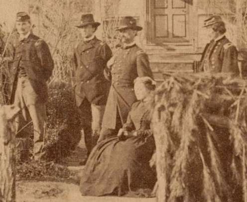
The City Point page now includes photographic thumbnails with links to The Medford Historical Society Civil War Photograph Collection as well as thumbnails from the Album of Civil War Photographs belonging to Alice Mason at the Boston Athenaeum (link to the general collection). There is some overlap in subjects. Capt. Andrew J. Russell is identified in one photograph from Medford. Broadway Landing photos were moved to their own page.
2 Comments

C. S. A. Leadworks and mapping mistakes

10/25/2017

0 Comments

 
Some of the lead expended by the Confederate forces at Petersburg was likely smelted at the leadworks constructed in 1862 on the southwest edge of town.This important facility was originally outside the city's defenses, but at some point new earthworks were built to protect it Strangely, a Confederate map of the Petersburg region compiled in summer 1864 misplaces the leadworks.
New: Confederate Leadworks
0 Comments

Colonel John A. Baker, Frances Barlow, Theodore Lyman, Winslow Homer, horses....

9/27/2017

0 Comments

 
Picture
The "once splendid" Colonel John Algernon Baker, 3rd North Carolina Cavalry, picture downloaded from Find-A-Grave.
No obvious place to post this, so it will stay in blog format....  Bryce Suderow pointed out this reference in Theodore Lyman's notebooks (how did we miss this?), for June 21, 1864:

“Rode out to meet Barlow coming back.  A little beyond the Browder house descried him coming along at the head of his column, arrayed in a checked shirt and lolling about on his horse, more suo! “Hullo! See here!” shouted he “I’ve caught a Cambridge man!”- sure enough, there was a stout, handsome man, mounted on a fine white horse, and daintily dressed, with the stars of a Colonel on his collar and a fanciful sort of helmet of grey felt.  It was a certain Baker, in the law school at the time of Daves &c.  His effect was spoiled by Barlow’s quaint device of mounting a most scaly looking Adjutant, en croupe, behind him!  The wounded were carried to the Williams house” (pp 218-219).

And the next day, June 22, 1864:

“At Gen. Patrick’s found the once splendid Col. Baker, dusty & exhausted under a tree.  Barlow had relieved him of his horse”….(221).

Meade's Army: The Private Notebooks of Lt. Col. Theodore Lyman, edited by David W. Lowe, Kent State University Press, 2007.

Col. Baker was amongst Confederate cavalry captured by Barlow's Division of the U.S. II Corps on June 21, 1864, during the first day of what became known as the Battle of Jerusalem Plank Road.  Apparently he was recognized as a fellow Harvard man by Barlow and Lyman.
 
Baker's fine white horse seems to have been the horse Barlow bought from a Confederate colonel.  The horse may have been one of those sketched at Petersburg by Winslow Homer. The sketch was later used in the famous painting Prisoners at the Front, which shows Barlow and three Confederate prisoners.  The "handsome" colonel, however, looks nothing like any of the three Confederates.  See https://www.findagrave.com/cgi-bin/fg.cgi?page=gr&GRid=42651889 for more about Baker, including his six marriages.

Winslow Homer, Special Artist See this page for more about the painting and the horse.


0 Comments

September 10th, 2017

9/10/2017

0 Comments

 
Theodore Lyman, thanks to David Lowe, comes to the rescue and helps us identify a Charles Chapin drawing of dignitaries in an unnamed fort bastion as being Fort Wadsworth. Eventually we'll start a page for Fort Wadsworth, but- for the time being- this interesting sketch can be seen here:
​Charles H. Chapin, Special Artist
0 Comments

U. S.  Engineers at the Williams House.

9/5/2017

0 Comments

 
The combination of a photograph,detailed drawing,map, and diary provides an in depth look at construction activities as the federal line expanded in September,1864.

Engineers at the Williams House
0 Comments

The Expansion of Fort Fisher

9/1/2017

0 Comments

 
Fort Fisher began life as a small, enclosed fort in early fall 1864, when the Federals pushed west from the Weldon Railroad  with the objective of the Boydton Plank Road and the South Side Railroad.  U.S. forces were checked short of their goal in the Battle of Peebles Farm as the Confederates defended their supply routes and extended their lines for protection.  Fort Fisher grew into a large bastioned fort that anchored a refusal in the U.S. line.

On this site we are very interested in changes in the line to reflect changing military circumstances.
0 Comments
<<Previous
Forward>>

    The Petersburg Project

    "It was, after all, a Civil War."

    Archives

    November 2020
    November 2019
    October 2019
    August 2019
    May 2018
    April 2018
    February 2018
    November 2017
    October 2017
    September 2017
    July 2017
    June 2017
    May 2017
    April 2017

    Categories

    All

    RSS Feed

Proudly powered by Weebly
Picture