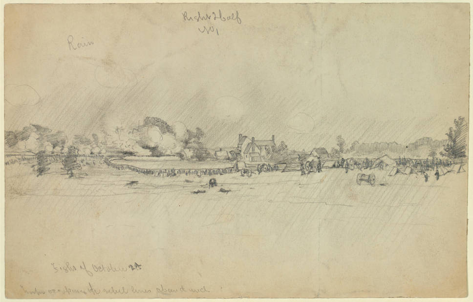
The Petersburg Project
  • Home
    • About Us
  • Blog and Updates
  • Petersburg Panorama 1865
  • Steeples of Petersburg
  • The Mine Explosion and its Crater
  • Petersburg in Pencil and Ink
    • Alfred R. Waud, Special Artist at Petersburg >
      • Waud Drawing of 5th Corps Fortifications
    • William Waud, Special Artist
    • Charles H. Chapin, Special Artist
    • Joseph Becker, Special Artist at Petersburg
    • Edwin Forbes, Special Artist at Petersburg
    • Winslow Homer, Special Artist
    • Edward Mullen, Special Artist at Petersburg
    • Andrew W. Warren, Special Artist
    • Enlisted Artists >
      • Charles Wellington Reed
      • Andrew McCallum
      • Francis Knowles
      • James William Pattison
      • Herbert Valentine
      • Howard A. Camp
  • Petersburg Photographs --So Many!
    • Working with Photographs
    • City Point
    • City Point Wharf Explosion, Aug. 9, 1864
    • Fort Rice?? We don't think so!
    • Federal Picket Line, Jerusalem Plank Road
    • Egbert Guy Fowx, Photographer at Petersburg
    • Timothy O'Sullivan, Photographer at Petersburg >
      • Fort Morton and Baxter Road Group
      • Fort Haskell Panorama
      • Fort Stedman Group
      • Gracie's Salient Group
      • Bombproofs behind Fort Haskell
      • Camp of the 50th N. Y. Engineers
    • David Knox, Photographer at Petersburg
    • William Redish Powell, Photographer at Petersburg
    • John Reekie, Photographer at Petersburg
    • Thomas C. Roche, Photographer at Petersburg
    • Andrew J. Russell, Photographer at Petersburg >
      • "Fort Mahone" CS Batteries 25 & 27
  • U. S. Military Railroad
    • Terminus of Military R. R. at City Point
    • City Point to Clark's Station
    • Pitkin's Station to Shooting Hill
    • Hancock's Junction/Jerusalem Plank Road
    • Parke's Station
    • Warren's Station
    • Patrick's Station
  • Maps and Topogs
    • Grand Medicine Pow-wow
    • Michler's Reports from Topographical Department
    • John E. Weyss, Cartographer
    • William H. Paine, Cartographer
    • Gilbert Thompson
  • Confederate Maps
    • Confederate Defenses 1862
    • Gilmer-Campbell Maps, 1864
    • Stevens Map July 1864
    • Fields of Fire
    • Coit's map of the Crater Battlefield
  • Federal Maps
    • Army of the Potomac, Routes of the Corps to Petersburg
    • June 18, 1864-Federal Engineers Map
    • June 18, 1864, 18th Corps
    • June 21, 1864, Federal Engineers Map
    • June 22, 1864. Second Corps at Jerusalem Plank Road
    • June 30, 1864 -- XVIII Corps Map
    • June-July, Undated Federal Engineers Map-
    • July 1864 Map of XVIII Corps Lines
    • Crater, Native American Perspective of the Crater
    • August 28, 1864, Michler Map
    • September 30, 1864, Warren Map
    • October 1864, Two IX Corps Maps
    • Nov. 2, 1864, Army of the Potomac
    • 1864, Coast Survey Map of Petersburg
    • NEW 1865-1867, Manuscript Survey Maps
    • 1864-1867, Michler-Weyss, Siege of Petersburg
    • 1865-1867, Michler Map Series
    • 1871, Map of Recapture of Ft. Stedman
    • 1881, Boydton Plank Road
  • Confederate Forts and Batteries
    • Dimmock Line >
      • Priest Cap
      • French Rifle Pits
    • Fort Clifton
    • "Fort Mahone" CS Batteries 25 & 27
    • Confederate 8-inch Columbiad
    • Leadworks
  • Federal Forts and Batteries
    • Battery X
    • Fort Alexander Hayes
    • Fort Avery
    • Fort Conahey
    • Fort Davis & Battery XXII
    • Fort Fisher
    • Fort Meikel --Photographic Views
    • Fort Morton
    • Fort Patrick Kelly
    • Fort Sedgwick, better known as Fort Hell,
    • Fort Wadsworth -- the Evolution
    • Fort Willcox or Battery XVI
  • Battlefield Features
    • Aiken House
    • Armstrong's Mill
    • Avery House
    • Bailey/Johnston Farm
    • Blandford Church
    • Broadway Landing, Appomattox River
    • The Crater
    • Cummings House
    • Dams and Inundations
    • WW Davis Farm
    • Dunn House
    • Friend House >
      • View from Friend House toward Gibben complex and Petersburg
    • Gibbons Properties
    • Globe Tavern / Weldon Railroad
    • Gregory House
    • Griffith Farm
    • Gurley House
    • Hare House
    • Hare House Hill
    • The "Horseshoe"
    • Jones House
    • Jordan House
    • Newmarket Racecourse
    • Pegram's Farm
    • Peebles Farm, Pegrams Farm, Poplar Springs Church
    • Shands House
    • Taylor Farm >
      • The Ice House
      • Surviving Taylor Barn
    • Williams House
  • Signal Towers and Trees
    • Some Operations of the Signal Corps at Petersburg
  • Archeology
    • Geology of the Crater
    • Fieldwork -- Petersburg
    • Civil War Sinks
    • Deserted Confederate Camp
    • Gracie's Countermine
    • LIDAR Forts and Batteries
  • Articles, Papers, Presentations
    • Shiman: A Note on Maps
    • The Siege Landscape: Through Fire and Ice at Petersburg
    • "The Rebel in the Road"
    • "A Strange Sort of Warfare Underground"
    • Lost Trenches of Petersburg: June 17
    • Between the Lines
    • Combat Trenching: An Introduction
    • Lowe -- Post-War Topographical Survey
    • Civil War Maps and Landscapes -- Observations
  • Kittens, Puppies & Ponies
  • Executions!
  • Notes on Leveled Earthworks
  • Civil War Combat Trenching
  • Depot Hospital at City Point
  • Dimmock Battery 5 Photographs
  • Pontoon Bridges
  • The Great Pontoon Bridge Across James River
  • Appomattox Mill Photographs

Another View of Federal Battery X

7/17/2017

0 Comments

 
Detail from an often misidentified photographic print from the National Archives. This is a view of Fort Stedman and Battery X from the front. Photographer was likely Timothy O'Sullivan because his was the only crew known to be operating on and around Hare House Hill in April 1865.
Picture
0 Comments

Small things are accruing that make the larger things more useful

6/26/2017

0 Comments

 
  • Two new stations on the USMRR have been illustrated and better mapping added.
  • Wow. You can really see Fort Alexander Hayes from Fort Sedgwick, a mile and a half distant!
  • A page was started on the Signal Corps operations around P'burg, soon to be fleshed out with maps and view sheds.....
  • The earthworks around Ft. Wadsworth underwent some amazing transformations during the siege, expanding then shrinking then settling into an "ordinary" battery, as illustrated by the Queen.
  • Another Gurley House drawing unearthed ....
  • The Griffith Farm was for sale in 1926! Also known as the Crater Farm. I think we can all be thankful that the guv'ment bought it.
0 Comments

Additions

6/19/2017

0 Comments

 
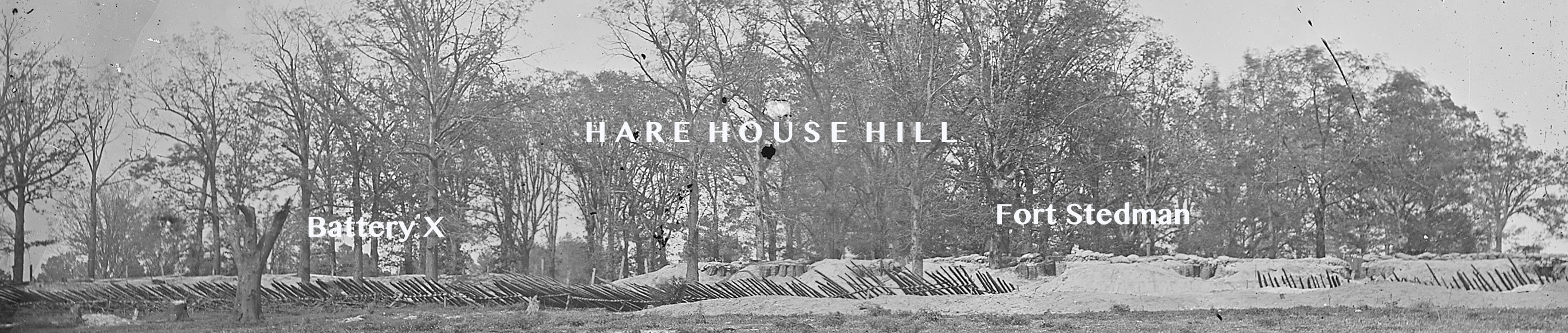
New material has been added to the Edwin Forbes page, annotating his drawing of the18th Corps advance on Petersburg on June 18th and comparing it to a Federal map titled "Sketch of Road  From Ponton Bridge at Point of Rocks to Petersburg Showing Line of Works Captured by the18th Army Corps".

A detailed obituary has been added to the page on enlisted artist Andrew McCallum.  He had a distinguished post war career.

Andrew McCallum
Edwin Forbes, Special Artist at Petersburg
 
0 Comments

FORT HELL (SEDGWICK)

6/4/2017

1 Comment

 
Fort Hell, like Fort Stedman, (and as its unofficial name suggests) was constructed under severe conditions.    It blocked the Jerusalem Plank Road (modern Crater Road), a  major highway in to Petersburg.  We will, no doubt, have more to add to this topic in the future- it   is already linked to many other pages.
1 Comment

Dams and Inundations

6/2/2017

0 Comments

 
The various entries on dams and inundations have been consolidated. This is where you will find discussions of Gracie's Dam, Harrison's Creek Dam, Rohoic Creek Dam, and the Hatcher's Run Dam, thus far.
0 Comments

The amazing appearing and disappearing Battery XXVII, plus  another signal tree....  Take a look.

5/25/2017

0 Comments

 
The lines on each side were frequently re-figured.  Here is one example.

​Plus, thanks to Edward Alexander, we've posted a new signal tree picture.
0 Comments

Fort Archer captured by Griffin's Division Union Fifth Corps, Sept. 30, 1864

5/22/2017

1 Comment

 
Picture
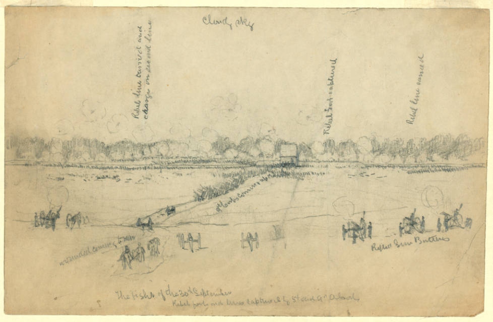
Above is a second drawing of the Peebles Farm/Pegram's Farm Operations, 30 Sept. -2 Oct. by the same unidentified artist. Drawn for Leslie's Illustrated Newspaper, both images are in the collection of the New-York Historical Society. The six-sided redoubt was afterwards reversed by Federal soldiers and renamed Fort Wheaton after Capt. J. H. Wheaton, 1st Michigan Infantry, killed during the fighting.
1 Comment

Pegram's Farm

5/13/2017

1 Comment

 
Picture
DL began a stub of an entry on Pegram's Farm inspired by a newly recognized drawing and a woodcut of the house and its later ruins. There was significant fighting on this property (owned by the Civil War Trust) on several occasions, particularly on October 2, 1864, when overly confident Federals advancing too far were repulsed by a series of counterattacks. Not a great moment for the Yankees but they ended up retaking and holding the ground. Fort Welch was erected on the site. 
1 Comment

Photographic Views of Fort Meikel

5/12/2017

0 Comments

 
Picture
Fort Meikel died an untimely death with the coming of Interstate 95 and the torturous exchanges that resulted in strip-mining the location of the fort. We can still see the fort in a few correctly identified photographs. Dr. Shiman led the way on this effort a few years back and we are just getting around to get these images posted and identified. More to come.
0 Comments

Harper's Weekly Special Artist, Charles H. Chapin added under Pencil and Ink

5/9/2017

0 Comments

 
Not much to say about him yet, but he contributes interesting views of Peebles Farm and Armstrong's Mill. And he is the only artist to have captured the location of the Pegram House outside the Union lines at Fort Welch.
0 Comments
<<Previous
Forward>>

    The Petersburg Project

    "It was, after all, a Civil War."

    Archives

    November 2020
    November 2019
    October 2019
    August 2019
    May 2018
    April 2018
    February 2018
    November 2017
    October 2017
    September 2017
    July 2017
    June 2017
    May 2017
    April 2017

    Categories

    All

    RSS Feed

Proudly powered by Weebly
Picture